Liverpool in Merseyside, England, United Kingdom — Northwestern Europe (the British Isles)
Castle Street
Laid out c1235

Photographed by Ian Lefkowitz, September 13, 2026
1. Castle Street Marker
Led to Liverpool Castle
Demolished 1726
The site now occupied by Derby Square & Victoria Monument
Topics. This historical marker is listed in these topic lists: Forts and Castles • Roads & Vehicles. A significant historical year for this entry is 1207.
Location. 53° 24.332′ N, 2° 59.406′ W. Marker is in Liverpool, England, in Merseyside. It is at the intersection of Castle Street and Lord Street, on the right when traveling north on Castle Street. Touch for map. Marker is at or near this postal address: 55 Castle St, Liverpool, England L2 9UB, United Kingdom. Touch for directions.

Regionally, this marker is in North West England. Globally, it is on the Atlantic Ocean, in the North Atlantic Region, in Europe, in Atlantic Europe, on one of the British Isles, in the Western World, and in the Anglosphere. Historically, it finds itself in what was once the Roman Empire.
Other nearby markers. At least 8 other markers are within walking distance of this marker: Castle Hey Chapel (a few steps from this marker); Victoria (within shouting distance of this marker); Derby Square
this page online
Also see . . . Castle Street, Liverpool (Wikipedia).
The street was one of the original seven streets that made up the medieval borough founded by King John in 1207, together with Water Street, Old Hall Street, Chapel Street, High Street, Tithebarn Street and Dale Street.(Submitted on October 11, 2026, by Ian Lefkowitz of New York, New York.)

Photographed by Ian Lefkowitz, September 13, 2026
2. Castle Street Marker
The plaque is located at Castle Street near Derby Square.

Photographed by Ian Lefkowitz, September 13, 2026
3. Derby Square
The former site of Liverpool Castle, now home to the Victoria Monument.
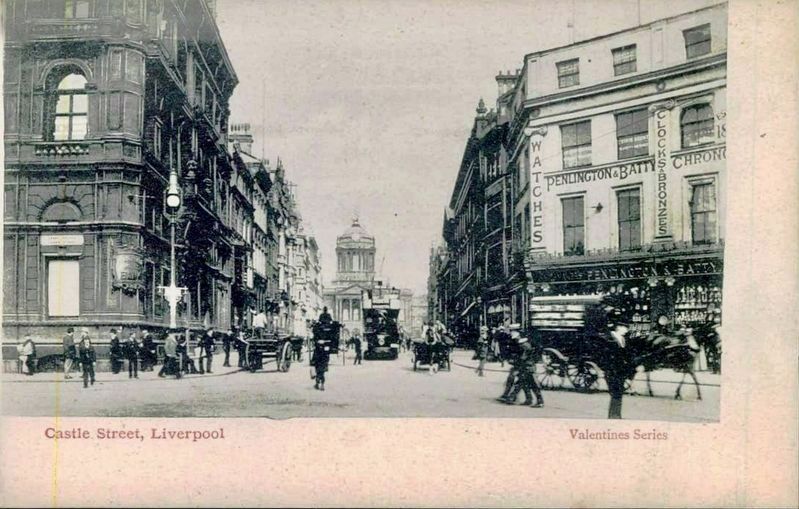
Photographed by John Valentine & Sons, circa 1905
4. Castle Street, Liverpool - looking north
The Town Hall is visible here at the end of Castle Street; the marker is roughly where the word “Watches” appears on the right, and the Victoria Monument would be located behind the viewer.
Credits. This page was last revised on October 13, 2026. It was originally submitted on October 11, 2026, by Ian Lefkowitz of New York, New York. This page has been viewed 9 times since then. Photos: 1, 2, 3. submitted on October 11, 2026, by Ian Lefkowitz of New York, New York. 4. submitted on October 13, 2026. • Andrew Ruppenstein was the editor who published this page.
