Stamford in Lincolnshire, England, United Kingdom — Northwestern Europe (the British Isles)
The Sundial at All Saints' Church
Photographed by Ray Gurganus, May 5, 2026
1. The Sundial at All Saints' Church Marker
How To Tell The Time Of Day Using This Sundial
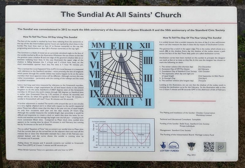
The face of the sundial is marked by hour lines radiating from the semicircle at the top of the dial. Intermediate quarter hours are marked by short lines in the border. The hour lines start at 5am (V in Roman numerals) at the top left, progressing anticlockwise to 4pm (IIII in Roman numerals) at the top right.
The Gnomon is a blade of metal set at a precisely calculated angle to the face of the sundial, marked as G on the illustration Whenever the sun shines on the dial the gnomon casts a shadow S and one edge of the gnomon's shadow falls on or between radiating hour lines. In the case illustrated, the upper edge of the shadow is falling between the 1 o'clock and 2 o'clock hour lines, on the third intermediate quarter hour line. The time is 1 hour 45 minutes pm.
This is termed the Local Apparent Time (LAT). It is Local because it is measured with reference to the Stamford meridian-more precisely the line of
this page online
Sailors had long used time measured by reference to the Greenwich meridian. In 1880 it became a legal requirement for all land based clocks in the United Kingdom to do the same. Stamford is 0.4837 degrees west of the Greenwich meridian. In 24 hours the earth rotates through 360 degrees to Stamford time is earlier than Greenwich Time by 1.93 minutes (1 minute 56 seconds) and always will be. So when the sundal in Stamford reads 1 hour 45 minutes, a sundial in Greenwich will read 1 hour 46 minutes and 56 seconds.
A further adjustment is needed. The earth's orbit around the sun is not circular it is very slightly elliptical and it is tilted with respect to the earth's equatorial plane. These two effects mean that the days in the year are not of equal length on only four occasions each year are the days exactly 24 hours long. Although the sundial measures the variable-length
Photographed by Ray Gurganus, May 5, 2026
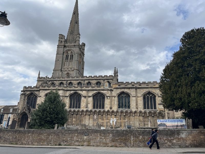
2. The Sundial on the wall of All Saints Church
The so-called "Equation of Time" lets us convert our sundial time to Mean time. Find the current date on the curved line on the adjacent chart and read off the minutes fast or slow. Our illustrative example has a date of 6th February (explained below) and the curve shows the sundial is running slow by 14 minutes and 4 seconds.
Adding those 14 minutes and 4 seconds converts our sundial to Greenwich Mean Time (GMT) of 2 hours 1 minute and 00 seconds pm.
When British Summer Time is in operation, add one hour to GMT.
How To Tell The Day Of The Year Using This Sundial
It is widely known that a sundial measures the time of day. It is less well-known chat it can also measure the date. It does this by means of Declination Curves.
The gnomon has a notch in the upper edge. This is the nodus which shows as a notch (N) in the shadow Every day the shadow of the nodus traces a path across the face of the dial. These daily paths are called declination curves.
Declination curves have been marked on this sundial. In principle the designer can mark as few or as many as they e In this case the designer has chosen to mark the following six dates:
1. The winter solstice (the shortest day), 21st December
2. Accession Day of HM The Queen, 6th February
3. Foundation Day of Stamford Civic Society, 12th October
4. The equinoxes, when day and night are of equal length, 23rd September & 20th March
5. St George's Day, 23rd April
6. The summer solstice (the longest day), 21st June
Looking at the illustration, we can see that the shadow of the nodus notch is tracking the declination curve for 6th February. So the illustration tells us that it is 2 hours 1 minute and 00 seconds GMT in the afternoon of 6th of February.
Topics. This historical marker is listed in this topic list: Science & Medicine.
Location. 52° 39.139′ N, 0° 28.852′ W. Marker is in Stamford, England, in Lincolnshire. It is on All Saints' Place, on the right when traveling west. Touch for map. Marker is at or near this postal address: 10 All Saints' Place, Stamford, England PE9 2AQ, United Kingdom. Touch for directions.

Regionally, this marker is in the Midlands. Globally, it is on the Atlantic Ocean, in the North Atlantic Region, in Europe, in Atlantic Europe, on one of the British Isles, in the Western World, and in the Anglosphere. Historically, it finds itself in what was once the Roman Empire.
Other nearby markers. At least 5 other markers are within 19 kilometers of this marker, measured as the crow flies: Stamford's Stone Heritage (about 150 meters away, measured in a direct line); The Hospital of Thomas Truesdale (about 180 meters away); St Michael's Churchyard and its surroundings (about 240 meters away); Stamford Theatre (approx. 0.3 kilometers away); Oundle Bridge (approx. 18.4 kilometers away).
Also see . . . Stamford, All-Saints Sundial (Society for Lincolnshire History and Archaeology). Picture of the sundial (Submitted on October 12, 2026.)
Credits. This page was last revised on October 12, 2026. It was originally submitted on October 12, 2026, by Ray Gurganus of Washington, District of Columbia. This page has been viewed 4 times since then. Photos: 1, 2. submitted on October 12, 2026, by Ray Gurganus of Washington, District of Columbia. • Andrew Ruppenstein was the editor who published this page.
