Milford Mine Memorial Park near Wolford in Crow Wing County, Minnesota — The American Midwest (Upper Plains)
Milford Mine Historic District
Photographed by McGhiever, June 27, 2025
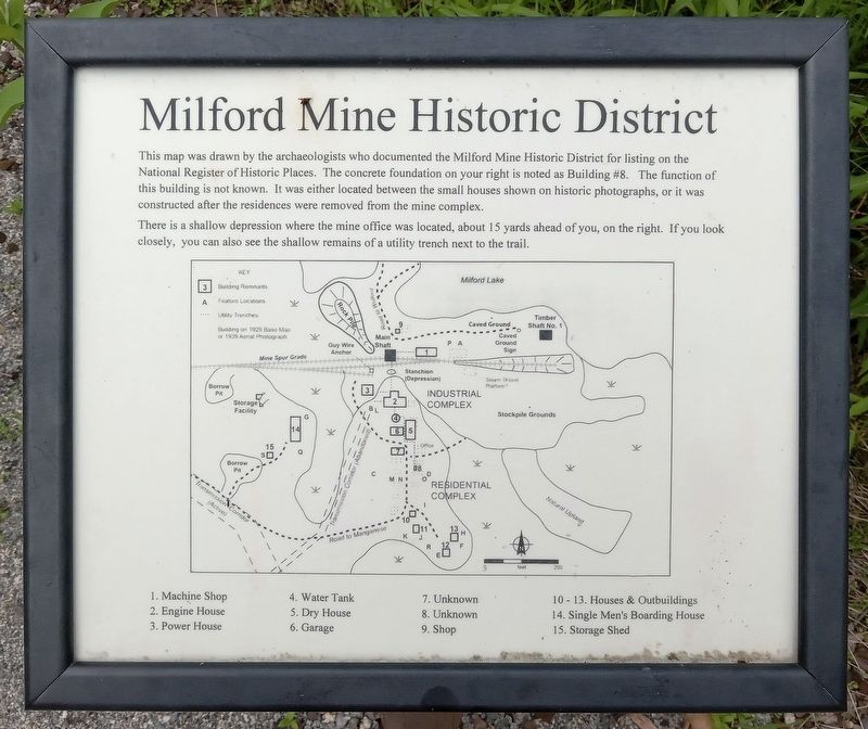
1. Milford Mine Historic District Marker
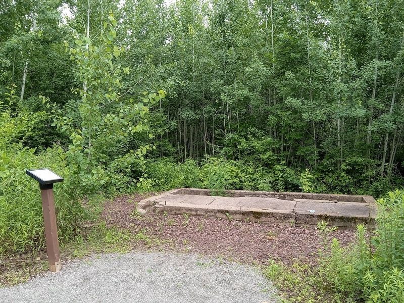
This map was drawn by the archaeologists who documented the Milford Mine Historic District for listing on the National Register of Historic Places. The concrete foundation on your right is noted as Building #8. The function of this building is not known. It was either located between the small houses shown on historic photographs, or it was constructed after the residences were removed from the mine complex.
There is a shallow depression where the mine office was located, about 15 yards ahead of you, on the right. If you look closely, you can also see the shallow remains of a utility trench next to the trail.
1. Machine Shop
2. Engine House
3. Power House
4. Water Tank
5. Dry House
6. Garage
7. Unknown
8. Unknown
9. Shop
10-13. Houses & Outbuildings
14. Single Men's Boarding House
15. Storage Shed
Topics. This historical marker is listed in these topic lists: Anthropology & Archaeology • Industry & Commerce.
Location. 46° 32.035′ N, 93° 58.33′ W. Marker is near Wolford, Minnesota, in Crow Wing County. It is in Milford Mine Memorial Park. It can be
this page online

Regionally, this marker is in the Northland. It is also in the American Midwest, in the Corn Belt, and in the Great River Road Region. Globally, it is in North America, the Great North Woods, the Western Hemisphere, the Western World, and the Anglosphere. Historically, it finds itself in what was once Rupert’s Land, the territory of the Mississippian Culture, and the Northwest Territory.
Other nearby markers. At least 8 other markers are within walking distance of this marker: Looking North (within shouting distance of this marker); Dry House (within shouting distance of this marker); Water Tank (within shouting distance of this marker); Engine House (within shouting distance of this marker); Milford Miners (about 400 feet away, measured in a direct line); Example of Timberwork Along the Main Shaft (about 400 feet away); The Mine Shaft (about 400 feet away); Mine Shaft Entrance (about 400 feet away). Touch for a list and map of all markers in Wolford.
Photographed by McGhiever, June 27, 2025
2. Milford Mine Historic District Marker and the Building #8 foundation
Credits. This page was last revised on October 13, 2026. It was originally submitted on October 13, 2026, by McGhiever of Minneapolis, Minnesota. This page has been viewed 2 times since then. Photos: 1, 2. submitted on October 13, 2026, by McGhiever of Minneapolis, Minnesota.
