Ludlow in Shropshire, England, United Kingdom — Northwestern Europe (the British Isles)
Ludlow Town Walls
Photographed by Ray Gurganus, May 17, 2026
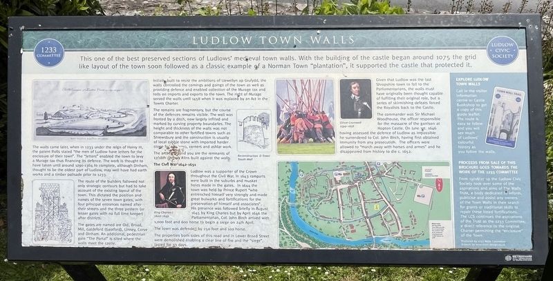
1. Ludlow Town Walls Marker
The walls came later, when in 1233 under the reign of Henry III, the patent Rolls stated "the men of Ludlow have letters for the enclosure of their town". The "letters" enabled the town to levy a Murage tax thus financing its defence. The work is thought to have taken until around 1290-1304 to complete, although Dinham, thought to be the oldest part of Ludlow, may well have had earth works and a timber palisade prior to 1233.
The route of the builders followed not only strategic contours but had to take account of the existing layout of the town. This dictated the position and names of the seven town gates, with four principal entrances named after their streets and the three postem (or lesser gates with no full time keeper) after districts.
The gates are named are Old, Broad, Mill, Galdeford (Gaolford), Linney, Corve and Dinham. An additional, pedestrian
this page online
Initially built to resist the ambitions of Llewellyn ap Grufydd, the walls controlled the comings and goings of the town as well as providing defence and enabled collection of the Murage tax and tolls on Imports and exports to the town. The right of Murage served the walls until 1458 when it was replaced by an Act in the Towns Charter.
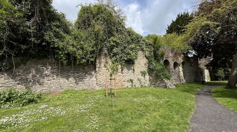
The remains are fragmentary, but the course of the defences remains visible. The wall was fronted by a ditch, now largely infilled and marked by curving property boundaries. The height and thickness of the walls was not comparable to other fortified towns such as Shrewsbury and the construction is usually of local rubble stone with imported harder stone for [illegible], corners and ashlar work.
The arches behind you are the remnants of 17/18th century kilns built against the walls.
The Civil War 1642-1651
Ludlow was a supporter of the Crown throughout the Civil War, In 1643 ramparts were built in the suburbs and musket holes made in the gates. In 1644 the town was held by Prince Rupert "who entrenched himself very strongly and made
Photographed by Ray Gurganus, May 17, 2026
2. Remains of the Ludlow Town Walls
The town was defended by 250 foot and 100 horse.
The properties both sides of this road and in Lower Broad Street were demolished enabling a clear line of fire and the "siege", lasted for 33 days.
Given that Ludlow was the last Shropshire town to fall to the Parliamentarians, the walls must have originally been thought capable of fulfilling their original role, but a series of skirmishing defeats forced the Royalists back to the Castle.
The commander was Sir Michael Woodhouse, the officer responsible for the massacre of the garrison at Hopton Castle. On June 1st 1646 having assessed the defence of Ludlow as impossible he surrendered to Col. John Birch, having first obtained immunity from any prosecution. The officers were allowed to "march away with horses and armes" and he disappeared from history to die c.1652.
Topics. This historical marker is listed in these topic lists: Forts and Castles • Wars, Non-US. A significant historical year for this entry is 1233.
Location. 52° 21.95′ N, 2° 42.983′ W. Marker is in Ludlow, England, in Shropshire. It is on Saint John's Road, on the left when traveling east. Touch for map. Marker is at or near this postal address: 7 St John's Road, Ludlow, England SY8 1PG, United Kingdom. Touch for directions.

Regionally, this marker is in the Midlands. It is also on the British Marches. Globally, it is on the Atlantic Ocean, in the North Atlantic Region, in Europe, in Atlantic Europe, on one of the British Isles, in the Western World, and in the Anglosphere. Historically, it finds itself in what was once the Roman Empire.
Other nearby markers. At least 8 other markers are within walking distance of this marker: Mary Edwards (about 90 meters away, measured in a direct line); Lower Broad Street (about 120 meters away); The Broad Gate (about 120 meters away); No 49 Broad Street (about 180 meters away); Hospital of the Holy Trinity, the Virgin Mary and St John the Baptist (about 210 meters away); No 13 Broad Street (about 210 meters away); Nos 56-58 Broad Street (about 210 meters away); The Angel (about 240 meters away). Touch for a list and map of all markers in Ludlow.
Credits. This page was last revised on October 13, 2026. It was originally submitted on October 13, 2026, by Ray Gurganus of Washington, District of Columbia. This page has been viewed 7 times since then. Photos: 1, 2. submitted on October 13, 2026, by Ray Gurganus of Washington, District of Columbia. • Andrew Ruppenstein was the editor who published this page.
