March in Cambridgeshire, England, United Kingdom — Northwestern Europe (the British Isles)
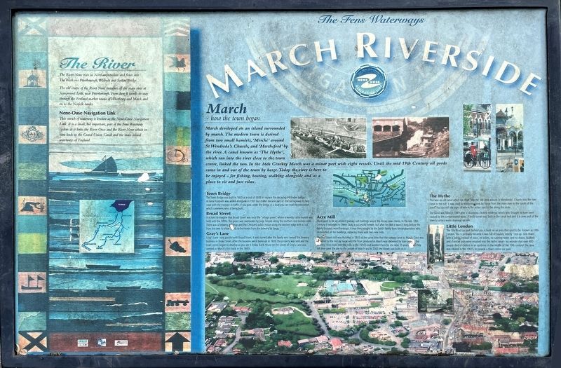
March Riverside
Photographed by Ray Gurganus
1. March Riverside Marker
March - how the town began
March developed on an island surrounded by marsh. The modern town is derived from two small hamlets, 'Merche' around St Wendreda's Church, and 'Mercheford' by the river. A canal known as 'The Hythe', which ran into the river close to the town centre, linked the two. In the 16th Century March was a minor port with eight vessels. Until the mid 19th Century all goods came in and out of the town by barge. Today the river is here to be enjoyed - for fishing, boating, walking alongside and as a place to sit and just relax.
Town Bridge
The Town Bridge was built in 1850 at a cost of £600 to replace the decaying old timber bridge. A metal footpath was added alongside in 1931 but it later became part of the carriageway to help cope with the increase in traffic. If you pass under the bridge in a boat you can read the inscription which commemorates it being built.
Broad Street
It is hard to imagine that Broad Street was once the "village green" where a weekly cattle market was held until the 1890s. The green was overlooked by large houses along the northern and eastern sides. There was a brewery,
this page online
Gray's Lane
Gray's Lane runs parallel with Broad Street, it was named after the family who owned the brewery business in Broad Street. After the business went bankrupt in 1839, the property was sold and the town centre began to develop as you see it today. Bank House on the corner of Gray's Lane was opened as March's first bank in the 1840s.
Acre Mill
There used to be an ancient granary and maltings where the library now stands. In the late 18th Century it belonged to Owen Gray, a successful brewer, but after he died it wasn't long before the family business went bankrupt. It was then bought by the Smith family from Nottinghamshire who demolished all the buildings, replacing them with two new mills.
The first steam mill was installed in 1847 at the same time that the railway came to March. Corn was delivered to the mill by barge and the flour produced in March was delivered by train all over the country. Hovis took over the mills in the 1950's and worked them for the next 25 years.

Photographed by Ray Gurganus, May 7, 2026
2. Looking down the river near the marker, with the library in the distance on the left
The Hythe
This was an old canal which ran from 'Merche' the area around St Wendreda's Church into the river close to the mill. It was used to transport goods by barge from the main river to the south of the town. You can still see signs of where the jetties used to be along the route.
The canal was filled in 1849 after a disastrous cholera epidemic which was thought to have been caused by the contaminated water. A brick tunnel was built in the canal bed and it is now part of the town's surface water drainage system.
Little London
The City Road car park behind you is built on an area that used to be known as Little London. This is probably because it was full of houses, mostly 'one up one down', with a ladder instead of stairs, no toilets, no running water and no drains. Rubbish and chamber pots were emptied into the Hythe canal no wonder that over 400 people died of cholera in an epidemic in the middle of the 19th century! The area was cleared in the 1960's to provide a town centre car park.
The River
The River Nene rises in Northamptonshire and flows into The Wash via Peterborough, Wisbech and Sutton Bridge. The old course of the River Nene branches off the main river at Stanground Lock, near Peterborough. From here it wends its way through the Fenland market towns of Whittlesey and March and on to the Norfolk border.
Nene-Ouse Navigation Link
This stretch of waterway is known as the Nene-Ouse Navigation Link. It is a small, but important, part of the Fens Waterway system as it links the River Ouse and the River Nene which in turn leads to the Grand Union Canal and the main inland waterways of England.
Topics. This historical marker is listed in these topic lists: Bridges & Viaducts • Waterways & Vessels.
Location. 52° 32.99′ N, 0° 5.243′ E. Marker is in March, England, in Cambridgeshire. Touch for map. Marker is in this post office area: March, England PE15 9JA, United Kingdom. Touch for directions.

Regionally, this marker is in East Anglia. Globally, it is on the Atlantic Ocean, in the North Atlantic Region, in Europe, in Atlantic Europe, on one of the British Isles, in the Western World, and in the Anglosphere. Historically, it finds itself in what was once the Roman Empire.
Other nearby markers. At least 5 other markers are within 21 kilometers of this marker, measured as the crow flies: March War Memorial (within shouting distance of this marker); The Stone Cross (approx. 0.9 kilometers away); March Railway Station (approx. 1.2 kilometers away); Ely Cemetery (approx. 20.6 kilometers away); a different marker also named Ely Cemetery (approx. 20.7 kilometers away).
Credits. This page was last revised on October 17, 2026. It was originally submitted on October 15, 2026, by Ray Gurganus of Washington, District of Columbia. This page has been viewed 5 times since then. Photos: 1, 2. submitted on October 15, 2026, by Ray Gurganus of Washington, District of Columbia. • Andrew Ruppenstein was the editor who published this page.
Editor’s want-list for this marker. photo of the marker within its surroundings • Can you help?
