Old Wiess and French Place, Montana — The American West (Mountains)
Gates of the Mountains
Photographed by Barry Swackhamer, June 24, 2026
1. Gates of the Mountains Marker
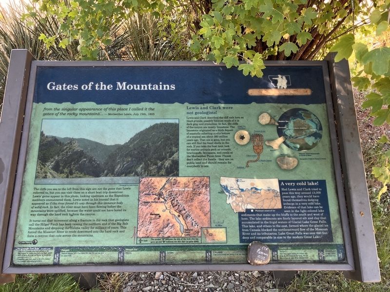
The cliffs you see to the left from this sign are not the gatesLewis referred to, but you can visit them on a short boat trip downriver. Lewis' gates appear in this photo, looking upstream as the Expedition members encountered them. Lewis noted in his journal that it appeared as if the river forced it's way through this immence body of solid rock. In fact, the river must have been flowing before there mountains were uplifted, because the water could not have bored its way through the hard rock to form a canyon.
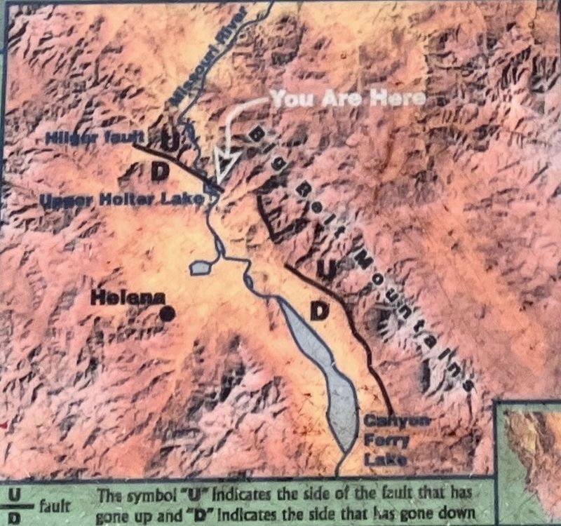
It turns out that movement along a fracture in the rock that geologists call the Hilger Fault has been raising the northern end of the Big Belt Mountains and dropping the Helena valley for millions of years. This forced the Missouri River to erode downward into the hard rock and form a canyon that cuts across there mountains.
Lewis and Clark were not geologists!
Lewis and Clark described the cliff rock here as black granite, possibly because much of it is dark gray and
this page online
A very cold lake!
Had Lewis and Clark tried to pass this way around 13,000 years ago, they would have found themselves dodging icebergs in a very cold lake. Evidence of that lake can be seen in the light-colored lake sediment that make up the bluffs to the south and west of here. The lake sediments are finely layered silt and clay that accumulated in the frigid waters of Glacial Laker Great Falls. This lake, and others to the east, formed when the glacial ice from Canada blocked the northeastward flow of the Missouri River and its tributaries. Lake Great Falls was over 600 feet deep and comparable to the size of the modern Great Lakes!
Photographed by Barry Swackhamer, June 24, 2026
2. Gates of the Mountains Marker, detail
The symbol "U" indicates the side of the fault that has gone up and "D" indicates the side that has gone down.
[across the bottom:]
Geologic Time (not to scale)
Divisions of geologic time were defined in the 19th Century by major changes in the fossil record. Most of the boundaries are marked by worldwide (?) events. Numerical dates were adopted in the 20th century using modern rock-dating techniques.
542 million years ago
Paleozoic Era
Limestone deposited when a sea covered the area. This rock now forms the canyon walls.
250 million years ago
Mesozoic Era
Triassic
208 million years ago
Jurassic
144 million years ago
Cretaceous
Compound folding and jaunting of the rock layers.
66 million years ago
Cenozoic Era
Tertiary
Hilger fault begins uplifting the northern end of there Big Belt Mountains causing the Missouri River to form the "gates of the rocky mountains."
2 million years ago
Quaternary
Ice forms Glacial Lake Great Falls
Erected by University of Montana Western.
Topics. This historical marker is listed in these topic lists: Exploration • Natural Features. A significant historical date for this entry is July 19, 1805.
Location. 46° 49.91′ N, 111° 57.116′ W. Marker
Photographed by Barry Swackhamer, June 24, 2026
3. Gates of the Mountains Marker

Regionally, this marker is in the American Mountain West and in the Lewis & Clark Corridor. Globally, it is in North America, the Western Hemisphere, the Western World, and the Anglosphere. Historically, it finds itself in what was once Rupert’s Land and also the Louisiana Purchase.
Other nearby markers. At least 8 other markers are within 13 miles of this marker, measured as the crow flies: Innovative Pioneer, Lasting Legacies (approx. 2.3 miles away); Welcome to Gates of the Mountains (approx. 2.3 miles away); Explorers, Prospectors & Ranchers (approx. 2.3 miles away); Shrewd Businessman, Caring Neighbor (approx. 2.3 miles away); Gates of the Mountain (approx. 3.6 miles away); A Perfect Defile (approx. 11.2 miles away); The Montana Central Railroad (approx. 11.2 miles away); York Gold Discovery Point (approx. 12.1 miles away).
Credits. This page was last revised on October 17, 2026. It was originally submitted on October 17, 2026, by Barry Swackhamer of Brentwood, California. This page has been viewed 7 times since then. Photos: 1, 2, 3. submitted on October 17, 2026, by Barry Swackhamer of Brentwood, California.
