
Lothian in Anne Arundel County, Maryland — The American Northeast (Mid-Atlantic)
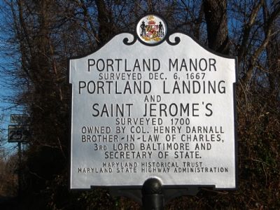
Portland Manor
Surveyed Dec. 6, 1667
| — | Portland Landing and Saint Jerome's | — |
Photographed by F. Robby, December 31, 2003
1. Portland Manor Marker
and
Saint Jerome's
Surveyed 1700
Owned by Col. Henry Darnall
brother-in-law of Charles,
3rd Lord Baltimore and
Secretary of State.
Erected by Maryland Historical Trust, Maryland State Highway Administration.
Topics and series. This historical marker is listed in these topic lists: Colonial Era • Settlements & Settlers. In addition, it is included in the Maryland Historical Trust series list. A significant historical date for this entry is December 6, 1922.
Location. 38° 47.553′ N, 76° 40.106′ W. Marker is in Lothian, Maryland, in Anne Arundel County. It is at the intersection of Greenock Road (Maryland Route 259) and Southern Maryland Boulevard ( Route 4), on the right when traveling north on Greenock Road. Touch for map. Marker is at or near this postal address: 5891 Southern Maryland Boulevard, Lothian MD 20711, United States of America. Touch for directions.

Regionally, this marker is in Central Maryland. It is also in the American Mid-Atlantic and on the Eastern Seaboard. Globally, it is in the North Atlantic Region, North America, the Western Hemisphere, the Western World, and the Anglosphere.
this page online
Other nearby markers. At least 8 other markers are within 3 miles of this marker, measured as the crow flies: Benjamin Welch Owens, CSA (approx. 2 miles away); Pvt. Benjamin Welch Owens (approx. 2 miles away); Uncovering Human Settlement Along the Patuxent River (approx. 2.1 miles away); Mount Calvert Historical and Archaeological Park (approx. 2½ miles away); Billingsley's Point (approx. 2½ miles away); Mount Calvert Federal Period Plantation House (approx. 2½ miles away); Explosive Scene (approx. 2.6 miles away); The War of 1812 and the Chesapeake Flotilla (approx. 2.6 miles away). Touch for a list and map of all markers in Lothian.
Another marker is no longer nearby. Billingsley's Point (was approx. 2½ miles away but has been reported to have been replaced with another marker now near it).
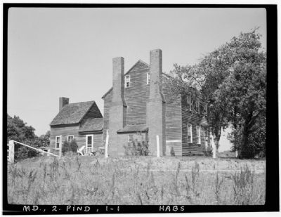
Delos H. Smith - Historic American Buildings Survey
2. Portland Manor

Photographed by Rico Ramirez, July 17, 2024
3. Portland Manor Marker
Credits. This page was last revised on July 23, 2024. It was originally submitted on October 25, 2007, by F. Robby of Baltimore, Maryland. This page has been viewed 2,994 times since then and 130 times this year. Photos: 1. submitted on October 25, 2007, by F. Robby of Baltimore, Maryland. 2. submitted on March 3, 2008, by Christopher Busta-Peck of Shaker Heights, Ohio. 3. submitted on July 17, 2024, by Rico Ramirez of Prince Frederick, Maryland. • J. J. Prats was the editor who published this page.
