Bures in Essex, England, United Kingdom — Northwestern Europe (the British Isles)
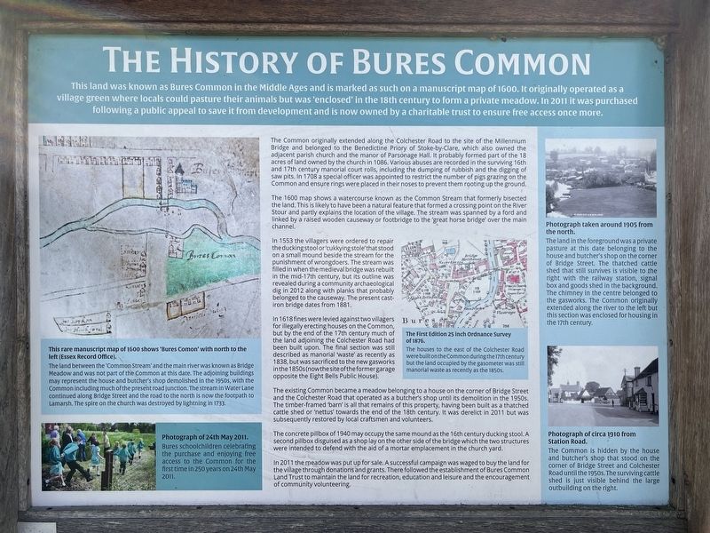
The History of Bures Common
Photographed by Ray Gurganus, April 18, 2026
1. The History of Bures Common Marker
The Common originally extended along the Colchester Road to the site of the Millennium Bridge and belonged to the Benedictine Priory of Stoke-by-Clare, which also owned the adjacent parish church and the manor of Parsonage Hall. It probably formed part of the 18 acres of land owned by the church in 1086. Various abuses are recorded in the surviving 16th and 17th century manorial court rolls, including the dumping of rubbish and the digging of saw pits. In 1708 a special officer was appointed to restrict the number of pigs grazing on the Common and ensure rings were placed in their noses to prevent them rooting up the ground.
The 1600 map shows a watercourse known as the Common Stream that formerly bisected the land.
this page online
In 1553 the villagers were ordered to repair the ducking stool or 'cukkying stole' that stood on a small mound beside the stream for the punishment of wrongdoers. The stream was filled in when the medieval bridge was rebuilt in the mid-17th century, but its outline was revealed during a community archaeological dig in 2012 along with planks that probably belonged to the causeway. The present cast- iron bridge dates from 1881.
In 1618 fines were levied against two villagers for illegally erecting houses on the Common, but by the end of the 17th century much of the land adjoining the Colchester Road had been built upon. The final section was still described as manorial waste' as recently as 1838, but was sacrificed to the new gasworks in the 1850s (now the site of the former garage opposite the Eight Bells Public House).
The existing Common became a meadow belonging to a house on the corner of Bridge Street and the Colchester Road that operated as a butcher's shop until its demolition in the 1950s. The timber-framed barn is all that remains of this property, having been built as a thatched cattle shed or 'nettus' towards the end of the 18th century. It was derelict in 2011 but was subsequently restored by local craftsmen and volunteers.
The concrete pillbox of 1940 may occupy the same mound as the 16th century ducking stool. A second pillbox disguised as a shop lay on the other side of the bridge which the two structures were intended to defend with the aid of a mortar emplacement in the churchyard.
In 2011 the meadow was put up for sale. A successful campaign was waged to buy the land for the village through donations and grants. There followed the establishment of Bures Common Land Trust to maintain the land for recreation, education and leisure and the encouragement of community volunteering.
Captions
This rare manuscript map of 1600 shows "Bures Comon' with north to the left (Essex Record Office).
The land between the 'Common Stream' and the main river was known as Bridge Meadow and was not part of the Common at this date. The adjoining buildings may represent the house and butcher's shop demolished in the 1950s, with the Common including much of the present road junction. The stream in Water Lane continued along Bridge Street and the road to the north is now the footpath to Lamarsh. The spire on the church was destroyed by lightning in 1733.
Photograph of 24th May 2011.
Bures schoolchildren celebrating the purchase and enjoying free access to the Common for the first time in 250 years on 24th May 2011.
The First Edition 25 inch Ordnance Survey of 1876.
The houses to the east of the Colchester Road were built on the Common during the 17th century but the land occupied by the gasometer was still manorial waste as recently as the 1850s.
Photograph taken around 1905 from the north.
The land in the foreground was a private pasture at this date belonging to the house and butcher's shop on the corner of Bridge Street. The thatched cattle shed that still survives is visible to the right with the railway station, signal box and goods shed in the background. The chimney in the centre belonged to the gasworks. The Common originally extended along the river to the left but this section was enclosed for housing in the 17th century.
Photograph of circa 1910 from Station Road.
The Common is hidden by the house and butcher's shop that stood on the corner of Bridge Street and Colchester Road until the 1950s. The surviving cattle shed is just visible behind the large outbuilding on the right.
Topics. This historical marker is listed in this topic list: Parks & Recreational Areas.
Location. 51° 58.304′ N, 0° 46.347′ E. Marker is in Bures, England, in Essex. It is at the intersection of Colchester Road and Bridge Street, on the right when traveling north on Colchester Road. Touch for map. Marker is at or near this postal address: 52 Colchester Road, Bures, England CO8 5AE, United Kingdom. Touch for directions.

Regionally, this marker is in the Greater South East. Globally, it is on the Atlantic Ocean, in the North Atlantic Region, in Europe, in Atlantic Europe, on one of the British Isles, in the Western World, and in the Anglosphere. Historically, it finds itself in what was once the Roman Empire.
Other nearby markers. At least 8 other markers are within 8 kilometers of this marker, measured as the crow flies: The Stour Valley Path at Bures (within shouting distance of this marker); Thomas Gainsborough (about 210 meters away, measured in a direct line); Bury St Edmunds Yard Signal Box (about 240 meters away); The History of Bures (about 240 meters away); The History of Chappel and Wakes Colne (approx. 5.2 kilometers away); A Short History of Beautiful Sudbury (approx. 7.6 kilometers away); Sudbury Station (approx. 7.6 kilometers away); The Lady Elizabeth (approx. 8 kilometers away). Touch for a list and map of all markers in Bures.
Credits. This page was last revised on November 1, 2026. It was originally submitted on October 19, 2026, by Ray Gurganus of Washington, District of Columbia. This page has been viewed 8 times since then. Photo 1. submitted on October 19, 2026, by Ray Gurganus of Washington, District of Columbia. • Andrew Ruppenstein was the editor who published this page.
Editor’s want-list for this marker. photo of the marker within íts surroundings • Can you help?
