Searsport in Waldo County, Maine — The American Northeast (New England)
Welcome to Sears Island
Photographed by Steve Stoessel, September 26, 2026
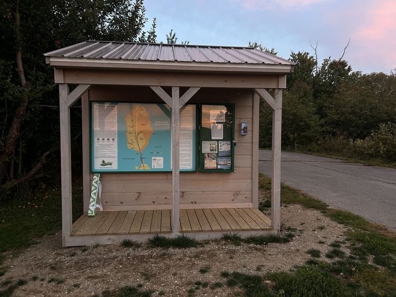
1. Welcome to Sears Island Marker
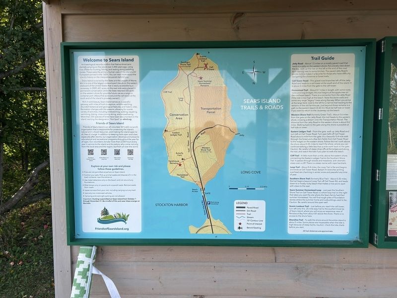
Welcome to Sears Island
Archaeological records confirm that Native Americans started camping on the island over 3,400 years ago, using it as a base for hunting, fishing, and resting along paddling routes. These were the primary human uses of the island until Europeans arrived in the 1600s. You can read more about the island's history on the interpretive panels behind you.
Sears Island is owned by the State and the people of Maine, and it is one of the largest undeveloped islands on the eastern seaboard of the United States that is easily accessible by a causeway. In 2009, 601 acres on the east side were placed in permanent conservation while the State retained 335 acres on the western shore for possible future use as a cargo or container port. (About five acres around the cell tower at the south end of the island is privately owned.)
Rich in wild beauty, Sears Island serves as a peaceful getaway, with miles of trails to explore, wildlife watching, abundant botanical and geological features, and historic sites. Recreation changes with the seasons, allowing for a wide variety of activities, including birdwatching, walking,
this page online
Friends of Sears Island
Friends of Sears Island is an all-volunteer 501(c)(3) nonprofit organization that is responsible for protecting the island's natural and cultural resources, and making the island open to all, free of charge. In addition to keeping trails open and clear, especially after storms, our organization develops and presents educational and recreational programs throughout the year for all ages. Our volunteers donate more than 2,500 hours every year in service to the island and its visitors, who come not only from the local area and the region, but from all over the world.
Explore at your own risk and please follow these guidelines.
• Fires are not permitted anywhere on Sears Island.
• Control your pets. Pick up animal waste and dispose of it in the trash container near the entrance.
• Use metal detectors only on the beach and not around any foundations.
• Ride horses only on paved and unpaved roads. Remove waste from roads.
•
Photographed by Steve Stoessel, September 25, 2026
2. Welcome to Sears Island Marker
• Use only non-motorized vehicles.
• Camping and overnight parking are not allowed.
Important: Hunting is permitted on Sears Island from October 1 through December 31. Be mindful of this and wear blaze orange on the trails.
Trail Guide
Jetty Road - About 1.5 miles on a mostly paved road that leads to a jetty on the western shore. For a lovely view down the bay, walk up the rise on the left at the end of the road to a clearing next to some birches. The paved Jetty Road's gentle incline makes it a favorite for those who have difficulty navigating the shoreline or forest trails.
Cell Tower Road - This gravel road branches left off the Jetty Road and leads to a cell tower at the south end of the island. It is about 2 miles from the gate to the cell tower.
Homestead Trail - About 0.7 miles in length, with some roots rocks and bog bridges, this trail begins at the apple tree on the northeast beach. There is a connector from the Jetty Road if the tide is too high at the beach. Note the stone walls and some very large "legacy" trees along the way. When you arrive at the large field, look to the left for a narrow trail leading to the remains of the old farmhouse. Just beyond those remains is a path to the eastern beach (0.32 mi). Must be half tide or lower if you want to return to the causeway via the beach.
Western Shore Trail (formerly Green Trail) - About 0.6 miles from the gate on the Jetty Road, this trail heads to the western shore, crossing a stream onto the Transportation Parcel. The distance from the Jetty Road to the western shore is about 0.6 miles. Walking back to the gate along the shore is possible at half tide or lower.
Eastern Ledges Trail - From the gate, walk up Jetty Road and turn left on Cell Tower Road. Turn east (left) off Cell Tower Road about a mile from the gate. It's a beautiful 0.4 mile walk through the forest and a few fern fields from Cell Tower Road to the ledges on the eastern shore. Follow the trail north above the shore about 0.35 miles to reach the shore, where you can continue walking a little less than a mile north back to the gate Caution: Be careful of steep drop-offs at the ledges and along the trail, and watch the tide if you plan to walk the beach.
Cliff Trail - A little more than a mile, above the eastern shore, connecting the Eastern Ledges Trail to the Southern Shore Trail. It passes through woods and meadows, with dramatic views over a cliff. There is a steep ravine with rope handrails.
Loop Trail - About 0.4 miles, the Loop Trail is flat and begins and ends at Cell Tower Road. Balsam fir branches arching overhead are charming in winter snow and peaceful any time of year.
Southern Shore Trail (formerly Blue Trail) - About 0.35 miles, the trail begins beyond Loop Trail off Cell Tower Rd. and leads down to a mostly rocky beach that makes a nice picnic spot with views to the east.
Sears Summer Homestead Loop - Just past the Southern Shore Trail on Cell Tower Road is a short loop trail on the right that takes you past the site where the Sears family had their summer homestead. You will find rough piles of foundation stones where the summer home and outbuildings used to be. Caution: Be careful around the open well.
Scenic Lookout Trail - Just before you reach the cell tower, turn left onto this .25-mile easy trail to the southernmost tip of Sears Island, where you will enjoy an expansive view of Penobscot Bay from about 50' above the shore. There is no access to the shore here.
Shoreline Trail - To walk the shore around the entire island is about 5 miles. Some places are impassable when the tide is high because of steep banks. Caution: check the tide charts before you start.
All trail distances are approximate.
Erected by Friends of Sears Island.
Topics. This historical marker is listed in this topic list: Parks & Recreational Areas. A significant historical date for this entry is October 1, 2009.
Location. 44° 27.374′ N, 68° 52.914′ W. Marker is in Searsport, Maine, in Waldo County. It is on Sears Island Road 1.2 miles south of U.S. 1, on the left when traveling south. Touch for map. Marker is at or near this postal address: Sears Island Rd, Searsport ME 04974, United States of America. Touch for directions.

Regionally, this marker is in Midcoast Maine and on Penobscot Bay. It is also in the American Northeast, in New England, and on the Eastern Seaboard. Globally, it is in the North Atlantic Region, North America, the Western Hemisphere, the Western World, and the Anglosphere.
Other nearby markers. At least 8 other markers are within 2 miles of this marker, measured as the crow flies: Sears Island (here, next to this marker); Brigadier’s Island (here, next to this marker); Wassumkeag (a few steps from this marker); Honoring Robert and Marietta Ramsdell (a few steps from this marker); Marlboro Packard (approx. 1.4 miles away); The Home of a Hero / La maison d'un héros (approx. 1.6 miles away); The Growth of Ship Building: Isaac Carver / Le développement des chantiers navals : Isaac Carver (approx. 2 miles away); Carver Memorial Library / La Bibliothèque Carver (approx. 2 miles away). Touch for a list and map of all markers in Searsport.
Credits. This page was last revised on October 20, 2026. It was originally submitted on October 20, 2026, by Steve Stoessel of Niskayuna, New York. This page has been viewed 5 times since then. Photos: 1, 2. submitted on October 20, 2026, by Steve Stoessel of Niskayuna, New York.
