Cromer in Norfolk, England, United Kingdom — Northwestern Europe (the British Isles)
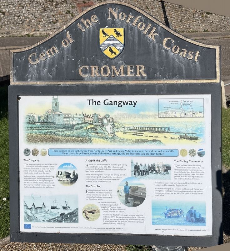
The Gangway
| — | Gem of the Norfolk Coast | — |
Photographed by Ray Gurganus, April 25, 2026
1. The Gangway Marker
The Gangway
The present Gangway and the lifeboat house which now houses the inshore lifeboat were laid out in 1902. In early years mules pulled carts of coal unloaded from the vessels on the beach up to the town.
Mules and horses continued to be used in later years to pull the bathing machines up for the winter, or if a high spring tide was due. To help the horses, the stones of the Gangway were laid with the upper edge slightly raised to catch the horse's hooves.
A Gap in the Cliffs
A stream ran down to the beach near this spot, carving a small valley in the cliffs. This valley provided access to the beach, and the fishing community kept its boats on the sands below.
Before the coming of the railways, this passage provided access to heavy goods brought to the town by sea such as coal, with local produce such as grain 'exported' in the opposite direction.
The Crab Pot
Fishing from boats launched
this page online
The flavoursome Cromer crabs became particularly popular in Victorian times, and today the boats concentrate entirely on crabs and lobsters.
Traditionally they had been caught by using hoop nets, and in the 1870s the crab pot was introduced. This could be left at sea overnight and greatly improved the catches. A rather bigger pot, the 'ped' pot, remains the principal means of catching crabs today.
The Fishing Community
From medieval times the fishing families of Cromer formed the core of the community. The town records trace the family lines down through the years, and in the late 1800s there were perhaps 50 boats working off both the east and west beaches of Cromer.
Two or three men would work these double-ended boats, each boat powered by oars and a dipping lugsail.
As Cromer developed, the Crescent and Brunswick Terrace were among those buildings which took advantage of the view of the summer sunrise over the sea and of the bustle of activity on the beach below.
Topics. This historical marker is listed in these topic lists: Industry & Commerce • Waterways & Vessels.
Location. 52° 55.852′ N, 1° 18.211′ E. Marker is in Cromer, England, in Norfolk. It can be reached from Brunswick Terrace, on the right when traveling north. Touch for map. Marker is at or near this postal address: 6 Brunswick Terrace, Cromer, England NR27 9GW, United Kingdom. Touch for directions.

Regionally, this marker is in East Anglia. Globally, it is on the Atlantic Ocean, in the North Atlantic Region, in Europe, in Atlantic Europe, on one of the British Isles, in the Western World, and in the Anglosphere. Historically, it finds itself in what was once the Roman Empire.
Other nearby markers. At least 6 other markers are within 14 kilometers of this marker, measured as the crow flies: Steamer, 1934 (about 120 meters away, measured in a direct line); Prospect and Promenade (approx. 0.2 kilometers away); Cromer Pier (approx. 0.3 kilometers away); Bronze Ballet, 1940 (approx. 0.3 kilometers away); The Pastons in North Walsham (approx. 13.4 kilometers away); The town with two stations (approx. 13.7 kilometers away).
Credits. This page was last revised on October 21, 2026. It was originally submitted on October 20, 2026, by Ray Gurganus of Washington, District of Columbia. This page has been viewed 6 times since then. Photo 1. submitted on October 20, 2026, by Ray Gurganus of Washington, District of Columbia. • Andrew Ruppenstein was the editor who published this page.
Editor’s want-list for this marker. photo of the marker within its surroundings • Can you help?
