Thetford in Norfolk, England, United Kingdom — Northwestern Europe (the British Isles)
Angles Way
Thetford
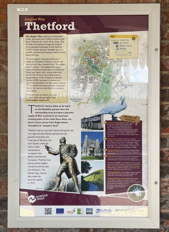
Photographed by Ray Gurganus, April 24, 2026
1. Angles Way Marker
The final section between Knettishall Heath and Thetford follows a section of the Icknield Way, claimed to be "the oldest road in Britain", and passes through a typical Breckland landscape of coniferous forest and heath with unique plant and animal life. Much of the arable area is designated as a Site of Special Scientific Interest (SSSI) because it is home to a significant population of rare stone curlews. The forested area also provides important habitat for scarce birds like the woodlark and nightjar.
Thetford's history dates as far back as the Neolithic period when the surrounding area provided a plentiful supply of flint. Located at an important crossing point of the Little Ouse River, the town's name comes from Anglo-Saxon Theodford or "people's ford".
Thetford was an important centre during the late Iron Age
this page online
Points of Interest
1. Thetford Grammar School, which originally dates back to Saxon times, was refounded in 1566 and remains active today. Thomas Paine, a Thetford-born writer and political activist who was involved in both the American War of Independence and the French Revolution, is the school's most famous student. A gilded statue of Thomas Paine stands outside the King's House in the town centre.
2. Thetford Priory, a former 12th century Cluniac monastery, was destroyed at the time of the Dissolution of the Monasteries but its ruins at Abbeygate remain an impressive site. The priory was founded in 1103 by Roger Bigod, the 1st Earl of Norfolk, who went on to build castles in Bungay and Framlingham in Suffolk.
3. The Ancient House is an attractive medieval building in White Hart Street that now serves as a Museum of Thetford Life.
4. Castle Park just southeast of the centre has extensive earthworks that represent the motte of a Norman castle although no trace of the former building remains.
The long-running BBC TV series Dad's Army was partly filmed in and around Thetford. A bronze statue of actor Arthur Lowe in the guise of leading character Captain Mainwaring can be found sitting on a park bench near the River Little Ouse in the town centre.
At Knettishall Heath, one of Suffolk's largest expanses of Breckland heath, three long-distance paths meet - Angles Way, Icknield Way and Peddars Way.
Barnham Cross Common, typical Breckland heath on the edge of Thetford, is home for several rare species of plant like spanish catchfly and tower mustard. Many species of butterfly can also be seen there, along with 60 species of breeding birds that include the hawfinch.
Topics. This historical marker is listed in these topic lists: Arts, Letters, Music • Religion & Religious Structures • Roads & Vehicles.
Location. 52° 25.153′ N, 0° 44.727′ E. Marker is in Thetford, England, in Norfolk. It can be reached from Station Road. Touch for map. Marker is at or near this postal address: 3 Station Road, Thetford, England IP24 1AS, United Kingdom. Touch for directions.

Regionally, this marker is in East Anglia. Globally, it is on the Atlantic Ocean, in the North Atlantic Region, in Europe, in Atlantic Europe, on one of the British Isles, in the Western World, and in the Anglosphere. Historically, it finds itself in what was once the Roman Empire.
Other nearby markers. At least 8 other markers are within walking distance of this marker: Thetford Priory - The Church and Nave (approx. 0.4 kilometers away); The Abbey before the Dissolution (approx. 0.4 kilometers away); Thetford Priory (approx. 0.4 kilometers away); The Refectory (approx. 0.4 kilometers away); The Prior's Lodging (approx. 0.4 kilometers away); St. Peter's Church (approx. half a kilometer away); Famous Scripts - Fact and Fiction (approx. 0.6 kilometers away); Ancient Capital of East Anglia (approx. 0.6 kilometers away). Touch for a list and map of all markers in Thetford.
Credits. This page was last revised on October 23, 2026. It was originally submitted on October 21, 2026, by Ray Gurganus of Washington, District of Columbia. This page has been viewed 7 times since then. Photo 1. submitted on October 21, 2026, by Ray Gurganus of Washington, District of Columbia. • Andrew Ruppenstein was the editor who published this page.
Editor’s want-list for this marker. photo of the marker within its surroundings • Can you help?
