Liverpool in Merseyside, England, United Kingdom — Northwestern Europe (the British Isles)
Wall Street
| — | The Heritage Trail at Liverpool ONE | — |
Photographed by Ian Lefkowitz, September 13, 2026
1. Wall Street Marker
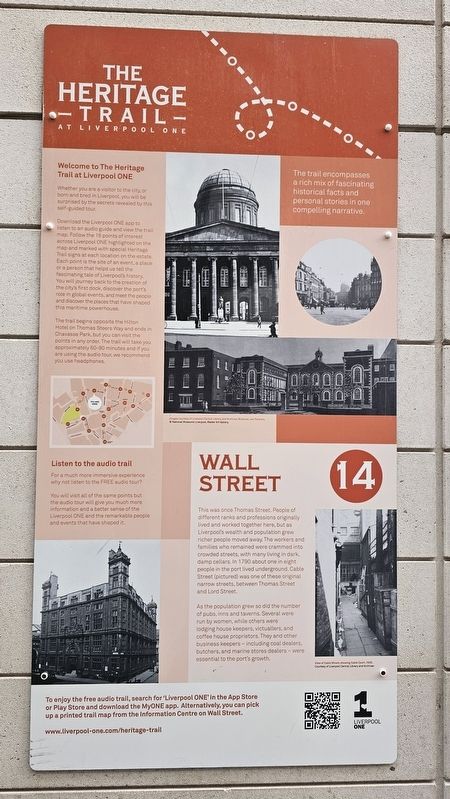
As the population grew so did the number of pubs, inns and taverns. Several were run by women, while others were lodging house keepers, victuallers, and coffee house proprietors. They and other business keepers — including coal dealers, butchers, and marine stores dealers — were essential to the port’s growth.
(Captions)
Images courtesy of Liverpool Central Library and Archives, Bluecoat, Joe Flannery.
© National Museums Liverpool, Walker Art Gallery.
View of Cable Street, showing Cable Court, 1929. Courtesy of Liverpool Central Library and Archives.
Welcome to The Heritage Trail at Liverpool ONE
Whether you are a visitor to the city, or born and bred in Liverpool, you will be surprised by the secrets revealed by this self-guided tour.
Download the Liverpool ONE app to listen to an audio guide and view the trail map. Follow the 16 points of interest across Liverpool ONE highlighted on the map and marked with special Heritage Trail signs at each location on the estate. Each point is the site of an event, a place or a person that helps us tell the fascinating tale of Liverpool’s history. You will journey back to the creation of the city’s first dock, discover the port’s role in global events, and meet the people and discover the places that have shaped this maritime powerhouse.
The trail begins opposite the Hilton Hotel on Thomas Steers Way and ends in Chavasse
this page online
The trail encompasses a rich mix of fascinating historical facts and personal stories in one compelling narrative.
Erected by Liverpool ONE. (Marker Number 14.)
Topics. This historical marker is listed in these topic lists: Industry & Commerce • Roads & Vehicles. A significant historical year for this entry is 1790.
Location. 53° 24.28′ N, 2° 59.233′ W. Marker is in Liverpool, England, in Merseyside. It can be reached from the intersection of South John Street and Wall Street, on the left when traveling south. Touch for map. Marker is at or near this postal address: 19 S John Street, Liverpool, England L1 8JQ, United Kingdom. Touch for directions.

Regionally, this marker is in North West England. Globally, it is on the Atlantic Ocean, in the North Atlantic Region, in Europe, in Atlantic Europe, on one of the British Isles, in the Western World, and in the Anglosphere. Historically, it finds itself in what was once the Roman Empire.
Other nearby markers. At
Photographed by Ian Lefkowitz, September 13, 2026
2. Wall Street Marker
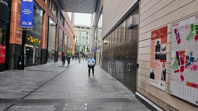
The marker is appropriately affixed to the wall of Wall Street in the outdoor shopping centre.
Also see . . . The Heritage Trail (Liverpool ONE). (Submitted on October 23, 2026, by Ian Lefkowitz of New York, New York.)
Credits. This page was last revised on October 24, 2026. It was originally submitted on October 23, 2026, by Ian Lefkowitz of New York, New York. This page has been viewed 7 times since then. Photos: 1, 2. submitted on October 23, 2026, by Ian Lefkowitz of New York, New York. • Andrew Ruppenstein was the editor who published this page.
