Golden Square Mile in Montréal, Québec — Central Canada (French-Canadian)
La station de pompage McTavish
⎯⎯⎯
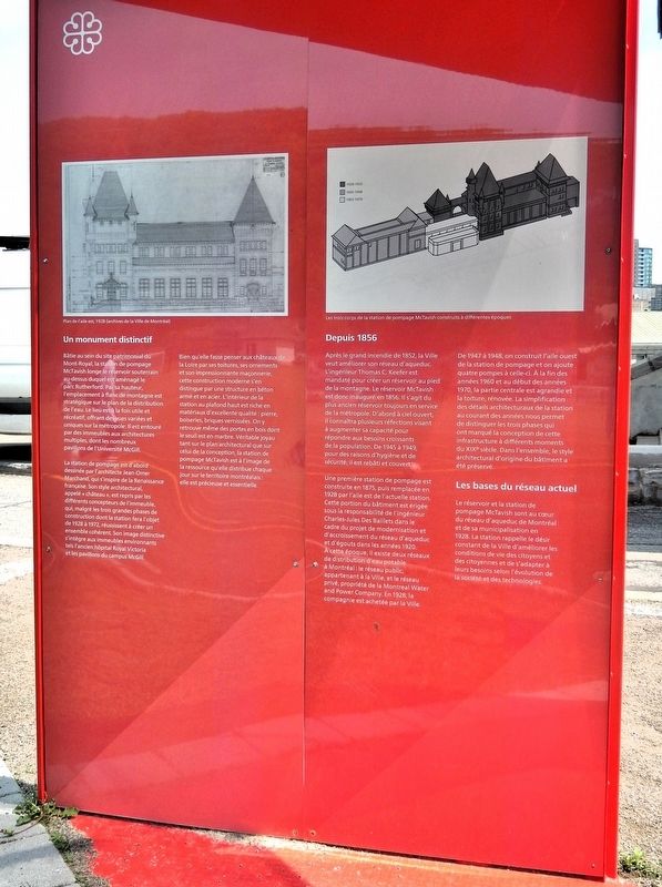
The McTavish Pumping Station
Photographed by Cosmos Mariner, May 22, 2024
1. La station de pompage McTavish / The McTavish Pumping Station Marker

Bâtie au sein du site patrimonial du Mont-Royal, la station de pompage McTavish longe le réservoir souterrain au-dessus duquel est aménagé le parc Rutherford. Par sa hauteur, l'emplacement à flanc de montagne est stratégique sur le plan de la distribution de l'eau. Le lieu est à la fois utile et récréatif, offrant des vues variées et uniques sur la métropole. Il est entouré par des immeubles aux architectures multiples, dont les nombreux pavillons de l'Université McGill.
La station de pompage est d'abord dessinée par l'architecte Jean-Orner Marchand, qui s'inspire de la Renaissance française. Son style architectural, appelé « château », est repris par les différents concepteurs de l'immeuble, qui, malgré les trois grandes phases de construction dont la station fera l'objet de 1928 à 1972, réussissent à créer un ensemble cohérent. Son image distinctive s'intègre aux immeubles environnants tels l'ancien hôpital Royal Victoria et les pavillons du campus McGill.
Bien qu'elle fasse penser aux châteaux de la Loire par ses toitures, ses ornements et son impressionnante maçonnerie, cette construction
this page online
Depuis 1856
Après le grand incendie de 1852, la Ville veut améliorer son réseau d'aqueduc. L'ingénieur Thomas C. Keefer est mandaté pour créer un réservoir au pied la montagne. Le réservoir McTavish est donc inauguré en 1856. Il s'agit du plus ancien réservoir toujours en service métropole. D'abord à ciel ouvert, il connaîtra plusieurs réfections visant à augmenter sa capacité pour répondre aux besoins croissants de la population. De 1945 à 1949, pour des raisons d'hygiène et de sécurité, il est rebâti et couvert.
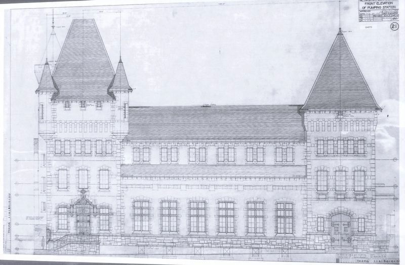
Une première station de pompage est construite en 1875, puis remplacée en 1928 par l'aile est de l'actuelle station. Cette portion du
Archives de la Ville de Montréal
2. Marker detail: Plan de l’aile est, 1928 /
East wing plan, 1928
East wing plan, 1928
De 1947 à 1948, on construit l'aile ouest de la station de pompage et on ajoute quatre pompes à celle-ci. À la fin des années 1960 et au début des années 1970, la partie centrale est agrandie et la toiture, rénovée. La simplification des détails architecturaux de la station au courant des années nous permet de distinguer les trois phases qui ont marqué la conception de cette infrastructure à différents moments du XIXe siècle. Dans l'ensemble, le style architectural d'origine du bâtiment a été préservé.
Les bases du réseau actuel
Le réservoir et la station de pompage McTavish sont au cœur du réseau d'aqueduc de Montréal et de sa municipalisation en 1928. La station rappelle le désir constant de la Ville
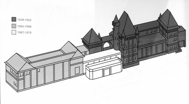
3. Marker detail: Les trois corps de la station de pompage McTavish
Les trois corps de la station de pompage McTavish construits à différentes époques • • • The three buildings of the McTavish pumping station built at different times.
Built within the Mont-Royal heritage site, the McTavish pumping station runs along the underground reservoir over which Rutherford Park is laid out. Due to its height, the mountainside location is strategic for water distribution. The place is both functional and recreational, offering varied and unique views of the city. It's surrounded by buildings with diverse architecture, including the many pavilions of McGill University.
The pumping station was first designed by the architect Jean-Orner Marchand, who drew inspiration from the French Renaissance. His architectural style, called the “château” style, was adopted by the various designers of the building, who, despite the three major construction phases the station underwent from 1928 to 1972, managed to create a cohesive whole. Its distinctive appearance blends in with the surrounding buildings like the old Royal Victoria Hospital and the McGill campus pavilions.
Although it brings to mind
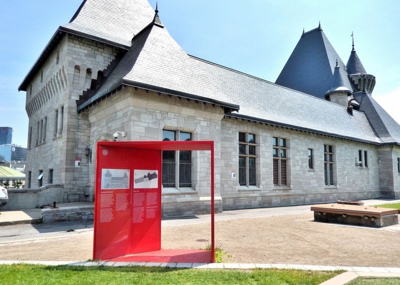
Photographed by Cosmos Mariner, May 22, 2024
4. La station de pompage McTavish / The McTavish Pumping Station Marker
The northwest corner of the McTavish Pumping Station is in the background.
Since 1856
After the great fire of 1852, the city wanted to improve its water network. Engineer Thomas C. Keefer was hired to build a reservoir at the foot of the mountain. The McTavish Reservoir was thus inaugurated in 1856. It is the oldest reservoir still in service in the metropolis. Originally open-air, it underwent several renovations aimed at increasing its capacity to meet the growing needs of the population. From 1945 to 1949, for reasons of hygiene and safety, it was rebuilt and covered.
The first pumping station was built in 1875, then replaced in 1928 by the east wing of the current station. This part of the building was constructed under the supervision
Photographed by Cosmos Mariner, May 22, 2024
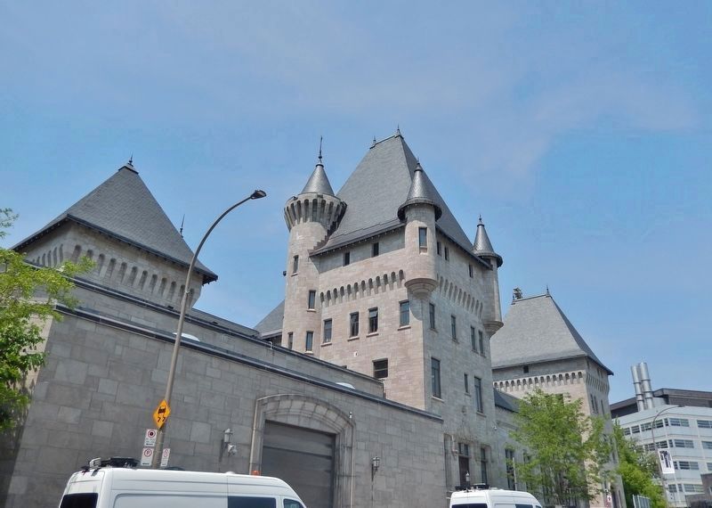
5. La station de pompage McTavish / The McTavish Pumping Station
View of the towers from Avenue du Docteur-Penfield (east/lower side of the reservoir and pumping station).
From 1947 to 1948, the west wing of the pumping station was built and four pumps were added. At the end of the 1960s and the beginning of the 1970s, the central part was expanded and the roof renovated. The simplification of the station’s architectural details over the years allows us to distinguish the three phases that marked the design of this infrastructure at different points in the 20th century. Overall, the building's original architectural style has been preserved.
The Foundations of the Current Network
The McTavish reservoir and pumping station are at the heart of Montreal's waterworks network and its municipalization in 1928. The station reflects the city's ongoing desire to improve citizens’ living conditions and adapt to their needs as society and technology evolve.
Topics.
Photographed by Cosmos Mariner, May 22, 2024
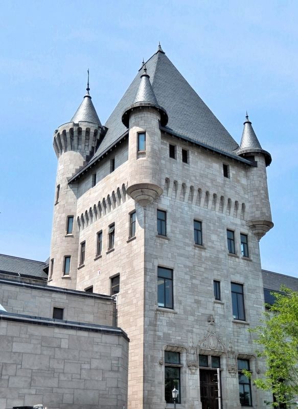
6. La station de pompage McTavish / The McTavish Pumping Station
Center tower detail (southeast corner).
Location. 45° 30.363′ N, 73° 34.744′ W. Marker is in Montréal, Québec. It is in Golden Square Mile. It can be reached from Avenue du Docteur-Penfield 0.2 kilometers north of Rue McTavish, on the left when traveling north. The marker is near the northwest corner of the McTavish Reservoir & Pumping Station. Touch for map. Marker is at or near this postal address: 855 Avenue du Docteur-Penfield, Montréal QC H3A 1Y2, Canada. Touch for directions.

Regionally, this marker is in Central Canada. Globally, it is in North America, the Western Hemisphere, and the Western World. Historically, it finds itself in what was once a British colony, the Viceroyalty of New France, the Haudenosaunee (Iroquois) Confederacy, and Rupert’s Land.
Other nearby markers. At least 8 other markers are within walking distance of this marker: So We Will Not Forget: / Puissions-nous ne jamais oublier : (about 150 meters away, measured in a direct line); The International Labour Organization (ILO) / L'Organisation internationale du Travail (OIT)
Photographed by Cosmos Mariner, May 22, 2024
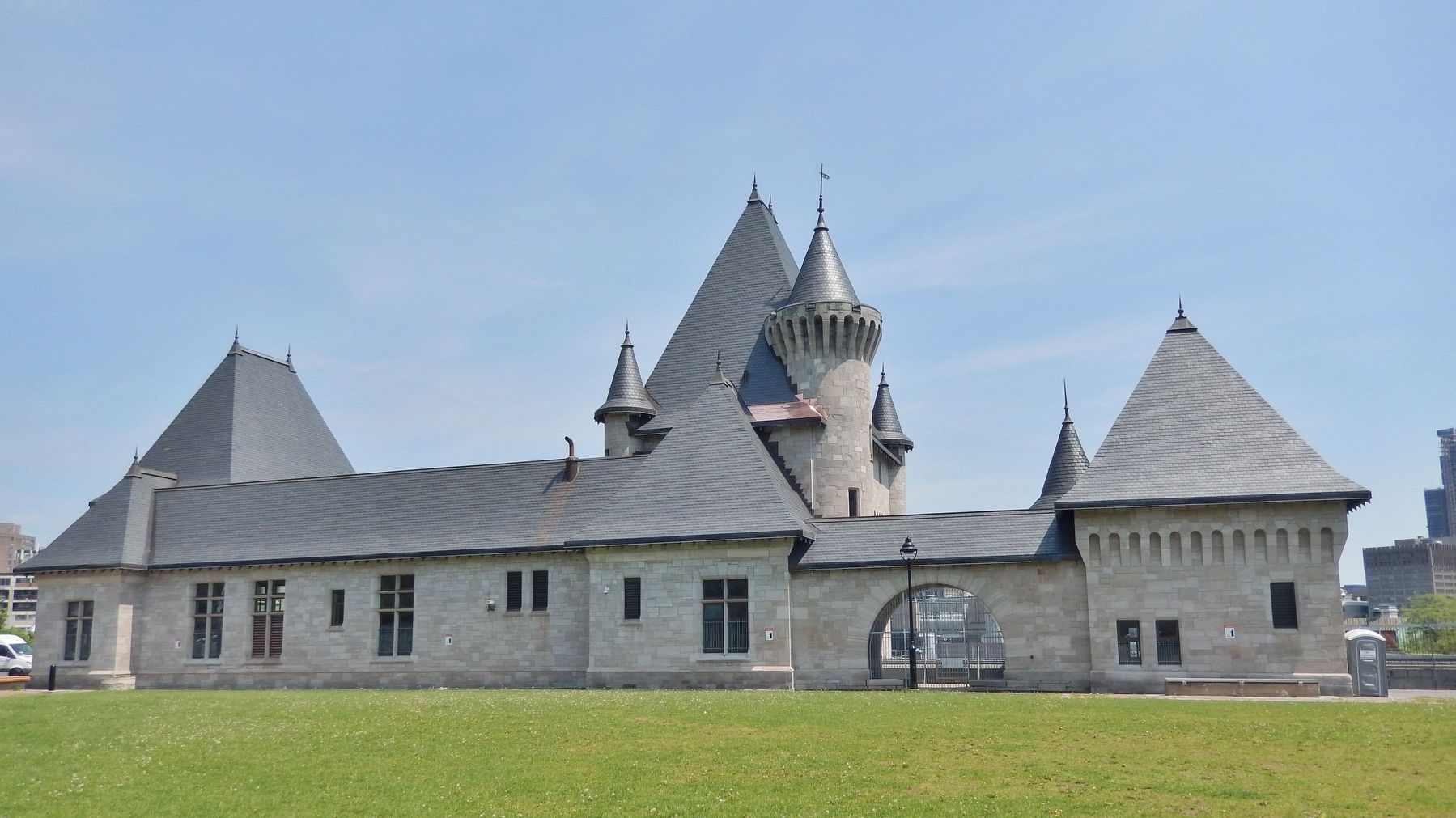
7. La station de pompage McTavish / The McTavish Pumping Station
Looking east across Rutherford Park to the west side of the buildings. The reservoir is underneath this park.
Also see . . . McTavish, water beneath the park and behind the stone (mtlarchives.com).
Excerpt: A castle-like pumping station and a covered reservoir show how Mount Royal’s slope became part of Montreal’s drinking-water system. At Parc Rutherford, the McTavish reservoir lies beneath the green space. The pumping station stands beside that hidden store of water on Mount Royal’s slope, linking a public park to an operating part of the city’s water supply.(Submitted on November 1, 2026, by Cosmos Mariner of Cape Canaveral, Florida.)
An open-air reservoir was built south of Avenue des Pins between 1854 and 1856 as Montreal developed its aqueduct. Its position on the mountain served a practical purpose: height allowed gravity to help redistribute water through the network. The slope was therefore doing municipal work as well as shaping the view above the city. The first McTavish pumping station followed in 1875. Reservoir and pumps performed related but different jobs, storing water and moving it through the system. As Montreal’s needs grew, the city modernized its distribution infrastructure. Municipalization in the 1920s brought existing networks together and helped set the context for replacing the old pumping station. McTavish formed part of a larger reorganization of how water reached the city.
The station stands at 815–855 Avenue du Docteur-Penfield. From the street, its stone volumes sit against the mountain, while the park occupies the surface above the neighbouring reservoir. The visible building and the underground water store explain one another: an elaborate civic exterior, a public outdoor space and a supply of water that continues to work for Montreal.
Credits. This page was last revised on November 1, 2026. It was originally submitted on October 31, 2026, by Cosmos Mariner of Cape Canaveral, Florida. This page has been viewed 4 times since then. Photos: 1, 2, 3, 4, 5, 6, 7. submitted on November 1, 2026, by Cosmos Mariner of Cape Canaveral, Florida.
