Ponca in Dixon County, Nebraska — The American Midwest (Upper Plains)
A Touch of the East
Photographed by Barry Swackhamer, July 17, 2025
1. A Touch of the East Marker
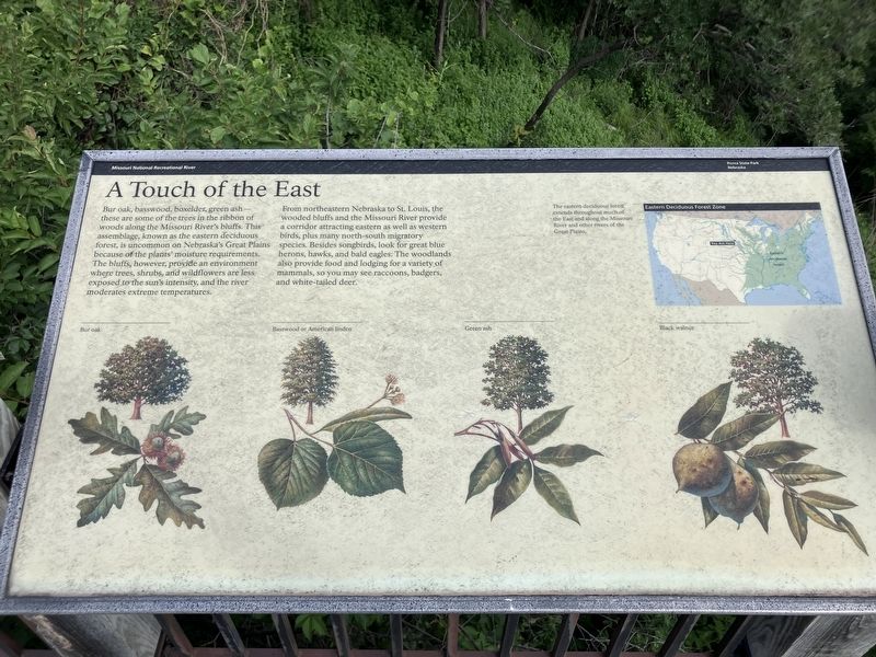
Captions: (upper right map) The eastern deciduous forest extends throughout much of the East and along the Missouri River and other rivers of the Great Plains.; Eastern Deciduous Forest Zone; (tree, left to right) Bur Oakj, Basswood or American linden; Green ash, Black walnut
From northeastern Nebraska to St. Louis, the wooded bluffs and the Missouri River provide a corridor attracting eastern as well as western birds, plus many north-south migratory species. Besides song birds, look for great blue herons, hawks and bald eagles. The woodlands also provide food and lodging for a variety of mammals, so you may see raccoons, badgers, and white-tailed deer.
Erected by Ponca State Park.
Topics. This historical marker is listed in this topic list: Natural Features.
Location. 42° 35.997′ N, 96° 42.649′ W. Marker is in Ponca, Nebraska, in Dixon County. It can be reached from State Highway 26E Spur near Highland Road.
this page online

Regionally, this marker is in Eastern Nebraska. It is also in the American Midwest, in the Corn Belt, and on the prairies. Globally, it is in North America, the Western Hemisphere, the Western World, and the Anglosphere. Historically, it finds itself in what was once the Louisiana Purchase.
Other nearby markers. At least 8 other markers are within 3 miles of this marker, measured as the crow flies: Up the Missouri (here, next to this marker); Gass's Election (here, next to this marker); The Great Missouri River (here, next to this marker); The Lewis & Clark Expedition (within shouting distance of this marker); Ponca State Park (approx. 0.2 miles away); The Ponca Villages (approx. 0.6 miles away); Texas City, Dakota Territory (approx. 1.2 miles away in South Dakota); Ponca (approx. 2.6 miles away). Touch for a list and map of all markers in Ponca.
Photographed by Barry Swackhamer, July 17, 2025
2. A Touch of the East Marker
Credits. This page was last revised on November 1, 2026. It was originally submitted on November 1, 2026, by Barry Swackhamer of Brentwood, California. This page has been viewed 10 times since then. Photos: 1, 2. submitted on November 1, 2026, by Barry Swackhamer of Brentwood, California.
