Dover in Kent, England, United Kingdom — Northwestern Europe (the British Isles)
New Bridge
| — | Historic Dover | — |
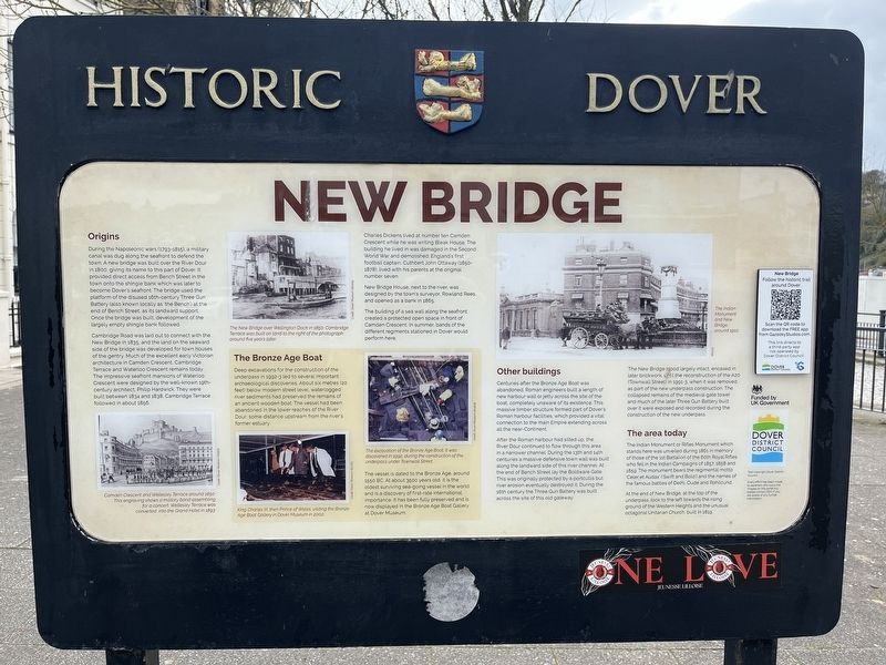
Photographed by Ray Gurganus, April 2, 2026
1. New Bridge Marker
During the Napoleonic wars (1793-1815), a military canal was dug along the seafront to defend the town. A new bridge was built over the River Dour in 1800, giving its name to this part of Dover. It provided direct access from Bench Street in the town onto the shingle bank which was later to become Dover's seafront. The bridge used the platform of the disused 16th-century Three Gun Battery (also known locally as 'the Bench') at the end of Bench Street, as its landward support. Once the bridge was built, development of the largely empty shingle bank followed.
Cambridge Road was laid out to connect with the New Bridge in 1835, and the land on the seaward side of the bridge was developed for town houses of the gentry. Much of the excellent early Victorian architecture in Camden Crescent, Cambridge Terrace and Waterloo Crescent remains today. The impressive seafront mansions of Waterloo Crescent were designed by the well-known 19th-century architect, Philip Hardwick. They were built between 1834 and 1838; Cambridge Terrace followed in about 1856.
Charles Dickens lived at number ten Camden Crescent while he was
this page online
New Bridge House, next to the river, was designed by the town's surveyor, Rowland Rees, and opened as a bank in 1865.
The building of a sea wall along the seafront created a protected open space in front of Camden Crescent. In summer, bands of the different regiments stationed in Dover would perform here.
The Bronze Age Boat
Deep excavations for the construction of the underpass in 1992-3 led to several important archaeological discoveries. About six metres (20 feet) below modern street level, waterlogged river sediments had preserved the remains of an ancient wooden boat. The vessel had been abandoned in the lower reaches of the River Dour, some distance upstream from the river's former estuary.
The vessel is dated to the Bronze Age, around 1550 BC. At about 3500 years old, it is the oldest surviving sea-going vessel in the world and is a discovery of first-rate international importance. It has been fully preserved and is now displayed in the Bronze Age Boat Gallery at Dover Museum.
Other buildings
Centuries after the Bronze Age Boat was abandoned, Roman engineers built a length of new harbour wall or jetty across the site of the boat, completely unaware of its existence. This massive timber structure formed part of Dover's Roman harbour facilities, which provided a vital connection to the main Empire extending across all the near-Continent.
After the Roman harbour had silted up, the River Dour continued to flow through this area in a narrower channel. During the 13th and 14th centuries a massive defensive town wall was built along the landward side of this river channel. At the end of Bench Street lay the Boldware Gate. This was originally protected by a portcullis but river erosion eventually destroyed it. During the 16th century the Three Gun Battery was built across the site of this old gateway.
The New Bridge stood largely intact, encased in later brickwork, until the reconstruction of the A20 (Townwall Street) in 1991-3, when it was removed as part of the new underpass construction. The collapsed remains of the medieval gate tower and much of the later Three Gun Battery built over it were exposed and recorded during the construction of the new underpass.
The area today
The Indian Monument or Rifles Monument which stands here was unveiled during 1861 in memory of those of the 1st Battalion of the 60th Royal Rifles who fell in the Indian Campaigns of 1857, 1858 and 1859. The monument bears the regimental motto 'Celer et Audax' ('Swift and Bold') and the names of the famous battles of Delhi, Oude and Rohilcund.
At the end of New Bridge, at the top of the underpass, look to the left towards the rising ground of the Western Heights and the unusual octagonal Unitarian Church, built in 1819.
Erected by Dover District Council.
Topics. This historical marker is listed in these topic lists: Bridges & Viaducts • Waterways & Vessels. A significant historical year for this entry is 1800.
Location. 51° 7.369′ N, 1° 18.881′ E. Marker is in Dover, England, in Kent. It is on Waterloo Crescent. Touch for map. Marker is at or near this postal address: 4-5 Waterloo Crescent, Dover, England CT16 1PA, United Kingdom. Touch for directions.

Regionally, this marker is in the Greater South East. Globally, it is on the Atlantic Ocean, in the North Atlantic Region, in Europe, in Atlantic Europe, on one of the British Isles, in the Western World, and in the Anglosphere. Historically, it finds itself in what was once the Roman Empire.
Other nearby markers. At least 8 other markers are within walking distance of this marker: Waterloo Crescent and the War Memorials (about 90 meters away, measured in a direct line); Dunkirk, 1940 (about 150 meters away); Charles Stewart Rolls (about 180 meters away); Old Market Hall (about 240 meters away); The Royal Norwegian Navy (approx. 0.2 kilometers away); Market Square (approx. 0.2 kilometers away); Instruments of Punishment (approx. 0.2 kilometers away); Operation Fuller (approx. 0.3 kilometers away). Touch for a list and map of all markers in Dover.
Credits. This page was last revised on November 3, 2026. It was originally submitted on November 1, 2026, by Ray Gurganus of Washington, District of Columbia. This page has been viewed 11 times since then. Photo 1. submitted on November 1, 2026, by Ray Gurganus of Washington, District of Columbia. • Andrew Ruppenstein was the editor who published this page.
Editor’s want-list for this marker. photo of the marker within its surroundings • Can you help?
