Dover in Kent, England, United Kingdom — Northwestern Europe (the British Isles)
Waterloo Crescent and the War Memorials
| — | Historic Dover | — |
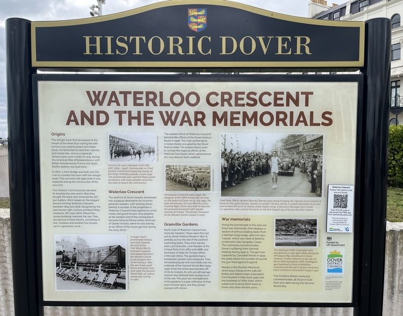
Photographed by Ray Gurganus, April 2, 2026
1. Waterloo Crescent and the War Memorials Marker
Origins
The shingle bank that developed at the mouth of the River Dour during the 16th century was used to beach and repair boats, for fishermen to land their catches and mend nets, and as a ropewalk (where ropes were made). In 1779, during the American War of Independence, with Britain threatened by France and Spain, North's Battery was built here.
In 1800, a New Bridge was built over the river to connect the town with the shingle bank. This survived until 1992 when it was replaced during the construction of the new A20.
The Harbour Commissioners decided to develop the area and in 1830 they bought the lease and removed the old gun battery. Work began on the elegant terrace forming Waterloo Crescent between 1834 and 1838. Designed by the well-known 19th-century architect Philip Hardwick, RA (1792-1870), these five-storey buildings overlook the sea. They are laid out in three blocks, consisting of five, nineteen and another five houses, set in a generous curve.
Caption
General Sir Cyril J Deverell, KCВ, КВЕ, ADC (1874-1947), Commander-in-Chief, Eastern Command inspecting troops at the King's
this page online
Waterloo Crescent
The seafront at Dover steadily developed into a popular destination for Victorian pleasure-seekers, with working docks behind. A number of the properties in Waterloo Crescent were opened as small hotels and guest houses. One property at the western end of the central block became home to Prince Arthur, third son of Queen Victoria, when he was serving as an officer of the Dover garrison during the early 1870s.
The western block of Waterloo Crescent became the offices of the Dover Harbour Board in 1948. The main central block is today mostly occupied by the Dover Marina Hotel. The eastern block used to contain the regional offices of the National Coal Board, which administered the now defunct Kent coalfield.
Captions
A single-track promenade railway was built towards the end of the First World War to transport supplies and equipment from the Western Docks to the Eastern Arm of the harbour. After the war it was used first to transport coal and, after the Second World War,
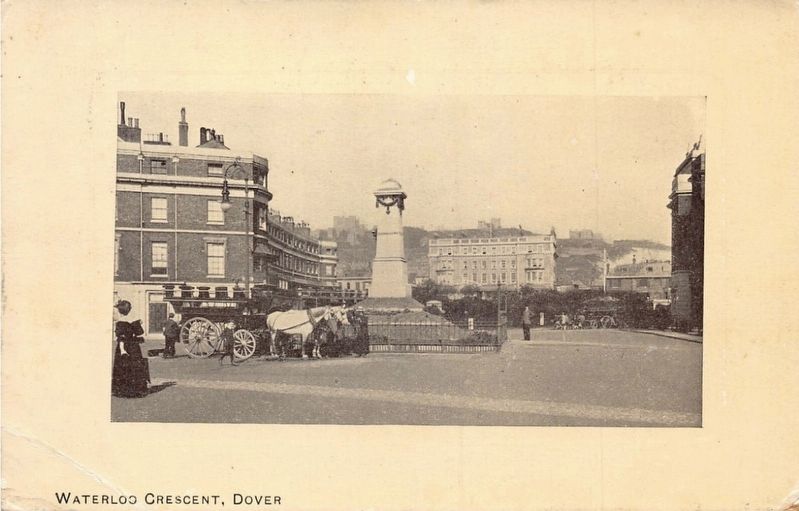
circa 1908
2. Waterloo Crescent, Dover
Christopher Cockerell (1910-1999), the designer of the SRN1 hovercraft, arriving on the beach at Dover on 25 July 1959, the 50th anniversary of Louis Blériot's cross-channel flight. Dover was later to become the principal hoverport with regular services to France. The former hoverport at the Western Docks closed in 2005.
Granville Gardens
North-east of Waterloo Crescent lies Granville Gardens. These were first laid out by Dover Harbour Board in 1877-8, partially across the site of the seafront swimming baths. They were named after Lord Granville, Lord Warden of the Cinque Ports from 1863 until 1888, and Secretary of State for Foreign Affairs. in the late 1800s. The gardens had a bandstand, pavilion and restaurant. They remained popular with townsfolk until the outbreak of the Second World War (1939-1945) when the entire area became off-limits to civilians. An anti-aircraft barrage balloon was tethered here during much of the war. The post-war reinstatement of the gardens is a pale reflection of their past Victorian glory, but they remain popular with visitors.
Caption
Chief Petty Officer Herbert (Barney) Barnes (1911-2004) bringing the Olympic torch ashore at Dover for the 1948 Olympic Games in London. He was met by a crowd estimated at 50,000, and handed the torch to Sidney Doble (1908-2004), a Butchery Manager from Dover Co-operative, who carried the torch on the first English leg of its journey from Greece.
War memorials
Along the promenade in this area are three war memorials. One displays a section of armour-plating taken from a German long-range, 406-mm gun, 'Caesar', which was sited at Batterie Lindemann near Sangatte, Calais. This memorial commemorates Dover's suffering from German shelling during 1940-5. The gun was captured by Canadian forces in 1944: the plate tallies the number of rounds the gun fired against England.
Nearby is the Dunkirk Memorial which pays tribute to the 338,226 British and Allied troops evacuated from Dunkirk in May-June 1940 and the hundreds of 'little ships' which sailed over to bring them back to Dover and other Kentish ports.
The Frontline Britain memorial commemorates all those in East Kent who died during the Second World War.
Caption
The destroyer HMS Codrington was bombed on 27 July 1940 while alongside HM Depot Ship Sandhurst in Dover Harbour. Further attacks on 29 July set fire to HMS Sandhurst. HMS Codrington was beached in front of Waterloo Crescent and the stern section remained there until was it removed in August 1947.
Erected by Dover District Council.
Topics. This historical marker is listed in these topic lists: Parks & Recreational Areas • War, World II.
Location. 51° 7.314′ N, 1° 18.874′ E. Marker is in Dover, England, in Kent. It is on Cambridge Road. Touch for map. Marker is at or near this postal address: 18 Cambridge Rd, Dover, England CT16 1JH, United Kingdom. Touch for directions.

Regionally, this marker is in the Greater South East. Globally, it is on the Atlantic Ocean, in the North Atlantic Region, in Europe, in Atlantic Europe, on one of the British Isles, in the Western World, and in the Anglosphere. Historically, it finds itself in what was once the Roman Empire.
Other nearby markers. At least 8 other markers are within walking distance of this marker: Dunkirk, 1940 (within shouting distance of this marker); New Bridge (about 90 meters away, measured in a direct line); Charles Stewart Rolls (approx. 0.2 kilometers away); The Royal Norwegian Navy (approx. 0.3 kilometers away); Operation Fuller (approx. 0.3 kilometers away); Old Market Hall (approx. 0.3 kilometers away); Instruments of Punishment (approx. 0.4 kilometers away); Market Square (approx. 0.4 kilometers away). Touch for a list and map of all markers in Dover.
Credits. This page was last revised on November 3, 2026. It was originally submitted on November 2, 2026, by Ray Gurganus of Washington, District of Columbia. This page has been viewed 8 times since then. Photos: 1. submitted on November 2, 2026, by Ray Gurganus of Washington, District of Columbia. 2. submitted on November 3, 2026. • Andrew Ruppenstein was the editor who published this page.
Editor’s want-list for this marker. photo of the marker within its surroundings • Can you help?
