Richmond in Le Val-Saint-François, Québec — Central Canada (French-Canadian)
Pont Mackenzie Bridge
Parc du souvenir - Rememberance Park
| — | Chemin Craig Road | — |
Photographed by Kevin Craft, October 20, 2026
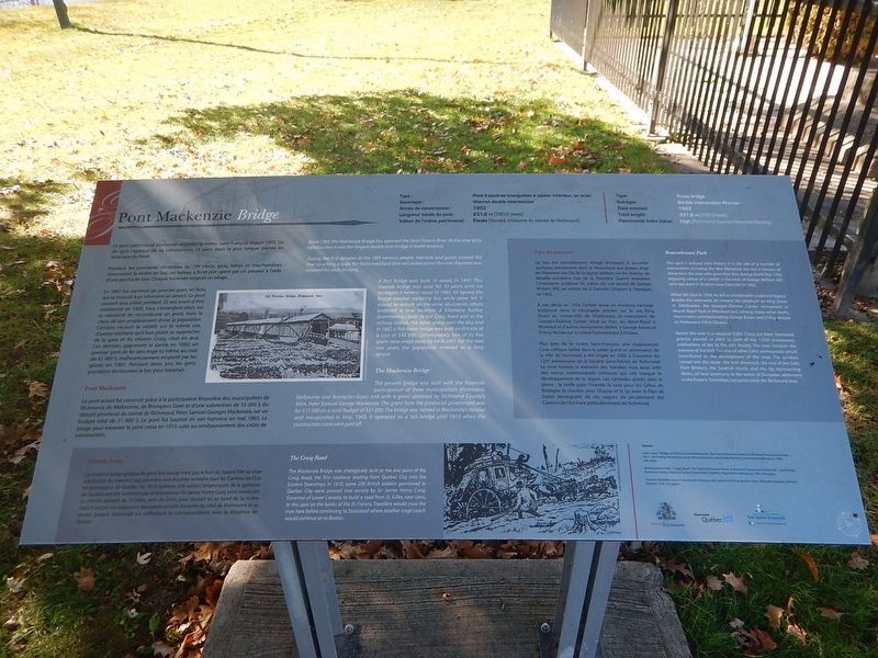
1. Pont Mackenzie Bridge Marker
{English text}
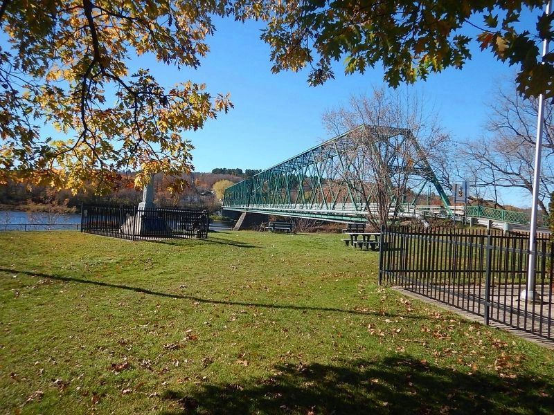
Since 1903, the Mackenzie Bridge has spanned the Saint Francis River. At the time of its construction it was the longest double truss bridge in North America.
During the first decades of the 19th century, people, livestock and goods crossed the river on a ferry, a wide, flat-bottomed boat that was poled across the river. Payment was required for each crossing.
A first bridge was built, in wood, in 1847. This covered bridge was used for 33 years until ice damaged it beyond repair in 1880. All agreed the bridge needed replacing but while some felt it should be re-built on the same abutments, others preferred a new location, a kilometre further downstream, closer to the Craig Road and to the railway station. The latter group won the day and in 1882 a first metal bridge was built on this site at a cost of $45,000. Unfortunately, two of its five spans were swept away by ice in 1901. For the next two years, the population reverted to a ferry service.
The Mackenzie Bridge
The present bridge was built with the financial participation of three municipalities (Richmond, Melbourne and Brompton-Gore) and with a grant obtained
this page online
Remembrance Park
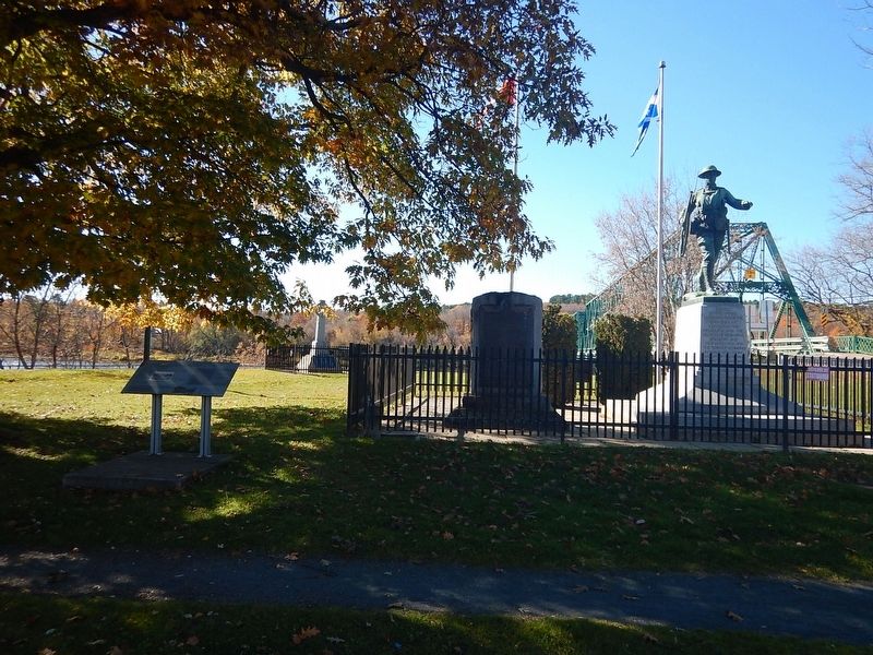
This spot is imbued with history. It is the site of a number of monuments including the War Memorial erected in honour of those from the area who gave their lives during World War I. The imposing statue of a soldier is the work of George William Hill, who was born in Shipton (now Danville) in 1862.
When Hill died in 1934, he left a considerable sculptural legacy. Besides this memorial, he created the cenotaph on King Street in Sherbrooke, the Georges-Étienne Cartier monument in Mount Royal Park in Montreal and, among many other works, monuments commemorating George Brown and D’Arcy McGee on Parliament Hill in Ottawa.
Nearer the river is a majestic Celtic Cross, cut from Stanstead granite, erected in 2002 as part of the 125th anniversary celebrations of the St. Patrick’s Society. The cross honours the memory of the Irish, but
Photographed by Kevin Craft, October 20, 2026
2. Wideview of Pont Mackenzie Bridge Marker
The Craig Road
The Mackenzie Bridge was strategically built at the end point of the Craig Road, the first roadway leading from Quebec City into the Eastern Townships. In 1810, some 200 British soldiers garrisoned in Quebec City were pressed into service by Sir James Henry Craig, Governor of Lower Canada, to build a road from St. Gilles, near Lévis, to this spot on the banks of the St. Francis. Travellers would cross the river here before continuing to Stanstead where another stage coach would continue on to Boston.
{French text}
Le pont patrimonial Mackenzie enjambe la rivière Saint-François depuis 1903. On dit qu’à l’époque de sa construction, ce pont avait la plus longue portée en Amérique du Nord.
Pendant les premières décennies du 19e siècle, gens, bétail et marchandises traversaient la rivière
Photographed by Kevin Craft, October 20, 2026
3. Mackenzie Bridge
En 1847 fut construit un premier pont, en bois, qui se trouvait à un kilomètre en amont. Ce pont couvert sera utilisé pendant 33 ans avant d’être condamné en 1880. Tous s’entendent alors sur la nécessité de reconstruire un pont, mais le choix de son emplacement divise la population. Certains veulent le rebâtir sur le même site, d’autres estiment qu’il faut plutôt se rapprocher de la gare et du chemin Craig, situé en aval. Ces derniers gagneront la partie en 1882; un premier pont de fer sera érigé ici même au coût de 45,000$, malheureusement emporté par les glaces en 1901. Pendant deux ans, les gens prendront de nouveau le bac pour traverser.
Pont MackenzieLe pont actuel fut construit grâce à la participation financière des municipalités de Richmond, de Melbourne, de Brompton Gore et d’une subvention de 15,000$ du député provincial du comté de Richmond, Peter Samuel Georges Mackenzie, sur un budget total de 51,000$. Le pont fut baptisé en son honneur en mai 1903. Le péage pour traverser le pont cessa en 1913 suite au remboursement des coûts de construction.
Parc du souvenir
Ce lieu est véritablement chargé d’histoire. Il accueille quelques monuments dont le Monument aux braves, érigé en l’honneur des fils de la région tombés sur les champs de bataille européen lors de la Première Guerre mondiale. L’imposante sculpture du soldat est une œuvre de George William Hill, un artiste né à Danville (Shipton à l’époque) en 1862.
À son décès en 1934, l’artiste laissa un immense héritage sculptural dont le cénotaphe présent sur la rue King Ouest au centre-ville de Sherbrooke, le monument de Georges-Étienne Cartier situé au Parc du Mont-Royal à Montréal et d’autres monuments dédiés à George Brown et D’Arcy McGee sur la colline Parlementaire à Ottawa.
Plus près de la rivière Saint-François, une majestueuse Croix celtique taillée dans le solide granit en provenance de la ville de Stanstead, a été érigée en 2002 à l’occasion du 125e anniversaire de la Société Saint-Patrick de Richmond. La croix honore la mémoire des Irlandais mais aussi celle des autres communautés celtiques qui ont marqué le développement de la région. Les symboles gravés dans la pierre : le trèfle pour l’Irlande, la rose pour les Celtes de Bretagne, le chardon pour l’Écosse et le lys pour le Pays de Galles témoignent de ces vagues de peuplement des Cantons-de-l’Est mais particulièrement de Richmond.
Chemin Craig
La situation géographique du pont Mackenzie n’est pas le fruit du hasard. Elle se situe à la finalité du chemin Craig, première voie d’entrée terrestre dans les Cantons-de-l’Est en provenance de Québec. En 1810, quelque 200 soldats britanniques de la garnison de Québec ont été mobilisés par le Gouverneur Sir James Henry Craig pour construire ce chemin partant de St-Gilles, près de Lévis, pour aboutir ici au bord de la rivière Saint-François. Les voyageurs pouvaient ensuite traverser du côté de Melbourne et se rendre jusqu’à Stanstead où s’effectuait la correspondance avec la diligence de Boston.
Erected by Town of Richmond.
Topics. This historical marker is listed in these topic lists: Bridges & Viaducts • Waterways & Vessels. A significant historical year for this entry is 1903.
Location. 45° 39.484′ N, 72° 8.546′ W. Marker is in Richmond, Québec, in Le Val-Saint-François. It is at the intersection of Main Street South and Craig Street, on the right when traveling south on Main Street South. Touch for map. Marker is in this post office area: Richmond QC J0B 2H0, Canada. Touch for directions.

Regionally, this marker is in Central Canada. Globally, it is in North America, the Western Hemisphere, and the Western World. Historically, it finds itself in what was once a British colony, the Viceroyalty of New France, the Haudenosaunee (Iroquois) Confederacy, and Rupert’s Land.
Other nearby markers. At least 8 other markers are within 18 kilometers of this marker, measured as the crow flies: Richmond WW1 Memorial (here, next to this marker); First Railway Train (a few steps from this marker); Richmond WW1 Memorial Plaque (approx. 0.3 kilometers away); Ulverton War Memorial (approx. 10.7 kilometers away); Windsor Cenotaph (approx. 14.7 kilometers away); Durham-Sud WW2 Memorial (approx. 15.2 kilometers away); Danville War Memorial (approx. 17.3 kilometers away); Private Timothy O'Hea - Victoria Cross No.324 / Soldat O’Hea - Croix Victoria no. 324 (approx. 17.3 kilometers away). Touch for a list and map of all markers in Richmond.
Credits. This page was last revised on November 4, 2026. It was originally submitted on November 3, 2026, by Kevin Craft of Bedford, Quebec. This page has been viewed 6 times since then. Photos: 1, 2, 3. submitted on November 3, 2026, by Kevin Craft of Bedford, Quebec.
