Currie in Pender County, North Carolina — The American South (South Atlantic)
Negro Head Point Road
| — | Moores Creek National Battlefield | — |
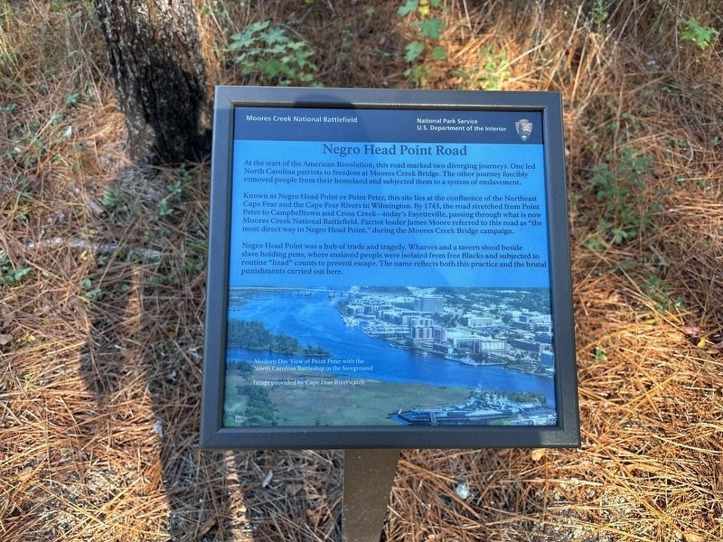
Photographed by Benjamin Rubin, November 8, 2026
1. Negro Head Point Road Marker
At the start of the American Revolution, this road marked two diverging journeys. One led North Carolina patriots to freedom at Moores Creek Bridge. The other journey forcibly removed people from their homeland and subjected them to a system of enslavement.
Known as Negro Head Point or Point Peter, this site lies at the confluence of the Northeast Cape Fear and the Cape Fear Rivers in Wilmington. By 1743, the road stretched from Point Peter to Campbelltown and Cross Creek—today's Fayetteville, passing through what is now Moores Creek National Battlefield. Patriot leader James Moore referred to this road as "the most direct way to Negro Head Point," during the Moores Creek Bridge campaign.
Negro Head Point was a hub of trade and tragedy. Wharves and a tavern stood beside slave holding pens, where enslaved people were isolated from free Blacks and subjected to routine "head" counts to prevent escape. The name reflects both this practice and the brutal punishments carried out here.
(caption) Modern Day View of Point Peter with the North Carolina Battleship in the foreground. Image provided by Cape Fear Riverwatch
Erected by National
this page online
Topics. This historical marker is listed in these topic lists: African Americans • Colonial Era • Settlements & Settlers • War, US Revolutionary. A significant historical year for this entry is 1743.
Location. 34° 27.441′ N, 78° 6.445′ W. Marker is in Currie, North Carolina, in Pender County. It can be reached from Moores Creek Drive west of North Carolina Route 210, on the left when traveling west. Touch for map. Marker is at or near this postal address: 40 Patriots Hall Dr, Currie NC 28435, United States of America. Touch for directions.

Regionally, this marker is in the Coastal Plain. It is also in the American South, specifically in the Upper South, in the Tidewater, and on the Eastern Seaboard. Globally, it is in the North Atlantic Region, North America, the Western Hemisphere, the Western World, and the Anglosphere. Historically, it finds itself in what was once the territory of the Mississippian Culture, one of the original Thirteen Colonies, one of the Confederate States of America, and the Antebellum South.
Other nearby markers. At least 8 other markers are within walking distance of this marker: Vanishing Longleafs (within shouting distance of this marker); Tar Kiln (within shouting distance of this marker); Ghosts of an Industry (about 300 feet away, measured in a direct line); Boxing the Pines (about 400 feet away); A Changing Landscape (about 500 feet away); Blackwater Highways (about 500 feet away); Battle of Moore’s Creek Bridge (about 600 feet away); Trees for a Navy (about 600 feet away). Touch for a list and map of all markers in Currie.
Also see . . . Moores Creek National Battlefield. National Park Service (Submitted on November 10, 2026.)
Credits. This page was last revised on November 10, 2026. It was originally submitted on November 8, 2026, by Benjamin Rubin of Columbia, South Carolina. This page has been viewed 3 times since then. Photo 1. submitted on November 8, 2026, by Benjamin Rubin of Columbia, South Carolina. • Bernard Fisher was the editor who published this page.
