Schuylerville in Saratoga County, New York — The American Northeast (Mid-Atlantic)
Lakes To Locks Passage
The Great Northeast Journey
| — | The Champlain Canal | — |
Photographed by Steve Stoessel, November 7, 2026
1. Lakes To Locks Passage Marker
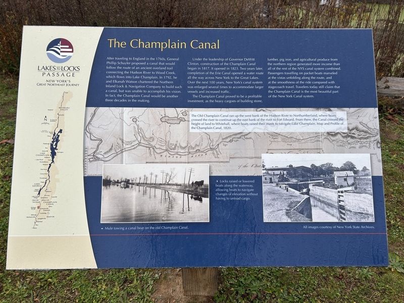
Under the leadership of Governor DeWitt Clinton, construction of the Champlain Canal began in 1817. It opened in 1823. Two years later, completion of the Erie Canal opened a water route all the way across New York to the Great Lakes. Over the next 100 years, New York's canal system was enlarged several times to accommodate larger vessels and increased traffic.
The Champlain Canal proved to be a profitable investment, as the heavy cargoes of building stone, lumber, pig iron, and agricultural produce from the northern region generated more income than all of the rest of the NYS canal system combined. Passengers travelling on packet boats marveled at the vistas unfolding along the route,
this page online
[ Map and Photo Captions: ]
• The Old Champlain Canal ran up the west bank of the Hudson River to Northumberland, where boats crossed the river to continue up the east bank of the river to Fort Edward. From there, the Canal crossed the height of land to Whitehall, where boats raised their masts to navigate Lake Champlain. Map and Profile of the Champlain Canal, 1820.
• Locks raised or lowered boats along the waterway, allowing boats to navigate changes of elevation without having to unload cargo.
• Mule towing a canal boat on the old Champlain Canal.
Topics. This historical marker is listed in this topic list: Waterways & Vessels. A significant historical year for this entry is 1792.
Location. 43° 5.988′ N, 73° 34.799′ W. Marker is in Schuylerville, New York, in Saratoga County. It is at the intersection of Empire State Trail and Ferry Street (New York State Route 29), on the right when traveling south on Empire State Trail. Touch for map. Marker is
Photographed by Steve Stoessel, November 7, 2026
2. Lakes To Locks Passage Marker

Regionally, this marker is in Upstate New York, in the Capital District, and in the Albany Metropolitan Area. It is also in the American Northeast and in the Mid-Atlantic. Globally, it is in North America, the Great North Woods, the Western Hemisphere, the Western World, and the Anglosphere. Historically, it finds itself in what was once New Netherland and also one of the original Thirteen Colonies.
Other nearby markers. At least 8 other markers are within walking distance of this marker: Champlain Canal Region (here, next to this marker); General Lafayette (a few steps from this marker); First Bridge (a few steps from this marker); Henry Knox And The Noble Train Of Artillery (a few steps from this marker); Boats Bring Business (within shouting distance of this marker); Near This Spot (within shouting distance of this marker); 1755 (within shouting distance of this marker); The Empire State Trail (within shouting distance of this marker). Touch for a list and map of all markers in Schuylerville.
Also see . . . Champlain Canal (Wikipedia). (Submitted on November 11, 2026, by Steve Stoessel of Niskayuna, New York.)
Credits. This page was last revised on November 11, 2026. It was originally submitted on November 11, 2026, by Steve Stoessel of Niskayuna, New York. This page has been viewed 2 times since then. Photos: 1, 2. submitted on November 11, 2026, by Steve Stoessel of Niskayuna, New York.
