Sioux City in Woodbury County, Iowa — The American Midwest (Upper Plains)
The Lewis and Clark Expedition
| — | Lewis and Clark National Historic Trail | — |
September 26, 2026
1. The Lewis and Clark Expedition Marker
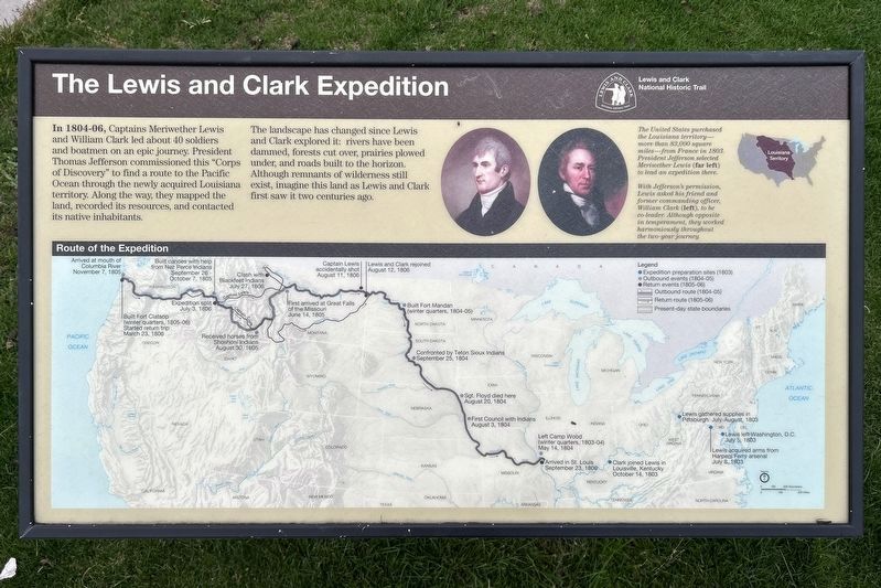
The landscape has changed since Lewis and Clark explored it: rivers have been dammed, forests cut over, prairies plowed under, and roads built to the horizon. Although remnants of wilderness still exist, imagine this land as Lewis and Clark first saw it two centuries ago.
The United States purchased the Louisiana territory—more than 83,000 square miles—from France in 1803. President Jefferson selected Meriwether Lewis (far left) to lead an expedition there.
With Jefferson's permission, Lewis asked his friend and former commanding officer, William Clark (left), to be co-leader. Although opposite in temperament, they worked harmoniously throughout the two-year journey.
Route of the Expedition
Expedition preparation sites (1803)
• Lewis left Washington, D.C. July 5, 1803
• Lewis acquired arms from Harpers Ferry arsenal July 8, 1803
• Lewis gathered supplies in Pittsburgh July-August, 1803
• Clark joined Lewis in Louisville, Kentucky October 14, 1803
Outbound events (1804-05)
• Left Camp Wood (winter quarters, 1803-04) May 14, 1804
• First Council with Indians August 3, 1804
• Sgt. Floyd died here August 20, 1804
• Confronted by Teton Sioux Indians September 25, 1804
• Built Fort Mandan (winter quarters, 1804-05)
• First arrived at Great Falls of the Missouri June 14, 1805
• Received horses from Shoshoni Indians August 30, 1805
• Built canoes with help from Nez Perce Indians September 26 - October 7, 1805
• Arrived at mouth of Columbia River November 7, 1805
Return events (1805-06)
• Built Fort Clatsop (winter quarters, 1805-06) Started return trip March 23, 1806
• Expedition split July 3, 1806
• (Captain Lewis) Clash with Blackfeet Indians July 27, 1806
• (Captain Lewis) Captain Lewis accidentally shot August 11, 1806
• Lewis and Clark rejoined August 12, 1806
• Arrived in St. Louis September 23, 1806
Topics and series.
this page online
Location. 42° 29.069′ N, 96° 23.595′ W. Marker is in Sioux City, Iowa, in Woodbury County. It can be reached from Floyd Boulevard west of Interstate 29. Located in Chris Larsen Park. Touch for map. Marker is at or near this postal address: 700 S Floyd Blvd, Sioux City IA 51101, United States of America. Touch for directions.

Regionally, this marker is in Western Iowa and in Loess Hills. It is also in the American Midwest, in the Lewis & Clark Corridor, and in the Corn Belt. Globally, it is in North America, the Western Hemisphere, the Western World, and the Anglosphere. Historically, it finds itself in what was once the territory of the Mississippian Culture and also the Louisiana Purchase.
Other nearby markers. At least 8 other markers are within walking distance of this marker: Lewis & Clark Floyd River Campsite Rock (here, next to this marker); Mouth of Floyd River (a few steps from this marker); Flooding in Sioux City
September 26, 2026
2. The Lewis and Clark Expedition Marker
Credits. This page was last revised on November 12, 2026. It was originally submitted on November 11, 2026. This page has been viewed 7 times since then. Photos: 1, 2. submitted on November 11, 2026.
