
Near Sunland Park in Doña Ana County, New Mexico — The American Mountains (Southwest)
El Paso del Rio del Norte

Photographed by Bill Kirchner, November 4, 2010
1. El Paso del Rio del Norte Marker
This canyon cut here by the Rio Grande marks the crossing of the historic Camino Real, or Royal Road, to La Tierra Adentra. Trackers and traders crossed the river here to begin the arduous journey north to Santa Fe. Permanent settlement of this area began with establishment of the Mission of Nuestra Señor de Guadalupe in 1659 in present day Ciudad Juarez.
Erected by New Mexico Historic Preservation Division.
Topics and series. This historical marker is listed in this topic list: Roads & Vehicles. In addition, it is included in the El Camino Real de Tierra Adentro series list. A significant historical year for this entry is 1659.
Location. 31° 47.764′ N, 106° 33.308′ W. Marker is near Sunland Park, New Mexico, in Doña Ana County. It is at the intersection of McNutt Road (Highway 273) and Racetrack Drive (State Highway 498), on the left when traveling south on McNutt Road. Touch for map. Marker is in this post office area: Sunland Park NM 88063, United States of America. Touch for directions.

Regionally, this marker is in the New Mexico’s Rio Grande Valley. It is also in the American Borderlands and in the Southwest.
this page online
Other nearby markers. At least 8 other markers are within 4 miles of this marker, measured as the crow flies: International Boundary and Water Commission (approx. 1.7 miles away); Madero Camp (approx. 1.8 miles away in Texas); Smeltertown (approx. 1.8 miles away in Texas); Old Main (approx. 3.3 miles away in Texas); The University of Texas at El Paso (approx. 3.4 miles away in Texas); Fort Bliss Officers' Quarters (approx. 3½ miles away in Texas); a different marker also named El Paso del Rio del Norte (approx. 3.6 miles away in Texas); The Camino Real (approx. 3.6 miles away in Texas).

Photographed by Bill Kirchner, November 4, 2010
2. El Paso del Rio del Norte Marker Reverse

Photographed by Bill Kirchner, November 4, 2010
3. El Paso del Rio del Norte Marker
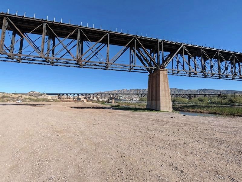
Photographed by Jimmy Emerson, November 15, 2026
4. El Paso del Rio del Norte Marker
The marker had been near the concrete pillar in the foreground.
It appears the area has recently flooded badly, not sure if that washed the marker away or if it was removed previously.
Credits. This page was last revised on November 17, 2026. It was originally submitted on November 17, 2010, by Bill Kirchner of Tucson, Arizona. This page has been viewed 2,300 times since then and 94 times this year. Last updated on November 16, 2026, by Jimmy Emerson of Dalton, Georgia. Photos: 1, 2, 3. submitted on November 17, 2010, by Bill Kirchner of Tucson, Arizona. 4. submitted on November 15, 2026, by Jimmy Emerson of Dalton, Georgia. • Devry Becker Jones was the editor who published this page.
