
Whittlesey in Cambridgeshire, England, United Kingdom — Northwestern Europe (the British Isles)
Whittlesey
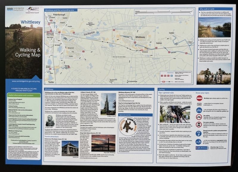
Photographed by Ray Gurganus, May 7, 2026
1. Whittlesey Marker
 Whittlesey sits on the very Western edge of the fens, approximately six miles east of Peterborough.
Before the fens were drained, Whittlesey was an island and the town's name has notes dating back to 973 where it was known as "Witlesig" in the Cartularium Saxonicum and then later on, in 1086, mentioned in the Domesday Book as "Witesie". The meaning is "Wit(t)el's island", deriving from either Witil, "the name of a moneyer", or a diminutive of Witta, a personal name; "eg", meaning "island, also used of a piece of firm land in a fen.
The name evolved first into Whittlesea and then the version we know today - Whittlesey.
Whittlesey has a varied and interesting mix of streets with architecture and historical notes ranging across the centuries.
Whittlesey was linked to both Peterborough in the west and March in the east by a Roman Fen Causeway. Excavations of the nearby Flag Fen show that there were thriving settlements nearby dating as far back as 1000 BCE. St Mary's Church, located in the town, houses Sir Harry Smith's Memorial and contains evidence of 15th Century work.
The Bronze Age settlement at Must
this page online
Tourist attractions Buttercross (The Butter Cross), PE7 1AB
Buttercross was a central point for the selling of goods and trading between 1680 and the 1800's. The structure still remains to this day in the central Markut Square with weekly markets still held at the site. It remains reminder of Whittlesey's rich trading and agricultural history.
St Mary's Church, PE7 1BG
Sir Harry George Waklyn Smith, son of a surgeon and Major in the Wisbech, Whittlesey and Thorney United Battalion, originated from Whittlesey and went on to become a successful rifleman in his own right after successful campaigns in the Napoleonic wars. Rising through the ranks militarily to become a hugely respected Major General, Sir Harry also became Baronet of Aliwal and the governor of Cape Colony, South Africa. He was notable for his leadership of the British forces during the battle of Aliwal in 1846 when he led Britain to victory against the Sikh army. His memorial bust is housed in St Mary's Church which underwent restoration in his memory in 1862. The town's Community College was also named after the local hero when it opened in 1953.
The Must Farm Project
The Must Farm project is the first landscape scale archaeological investigation of deep Fenland.
Kings Dyke Nature Reserve, PE7 1PD
The history of the site dates back to the 1920's when clay was dug by pick-axe and shovel. The site was worked out in the 1970's and was finally restored in 1995. It now offers a wonderful example of how Industrial land can be transformed to benefit both wildlife and the local community. Disabled access is also available to part of the reserve.
Whittlesey Museum, PE7 1BD
Founded in 1976 and located on the ground floor of the town's 19th-Century Town Hall, the museum houses collections highlighting the town's social history and development of the local area.
Flag Fen Archaeological Park, PE6 7QJ
Visit Flag Fen Archaeology Park to explore how the prehistoric people of the fen lived over 3000 years ago. Wander through a Bronze Age village, sit within the reconstructed roundhouses, and stand where our ancestors once stood by the ritual causeway.
Special events
Every January (barring a few exceptions) visitors have flocked to Whittlesey to witness its annual Straw Bear Festival. Traditionally, on Plough Tuesday, the day after the first Monday after twelfth night, a man or boy was covered in straw and led from house to house to dance in exchange for gifts of money, food, tobacco or beer! Today, the festival takes place the first weekend after Plough Monday and the "bear" is led around the town on the Saturday followed by a huge procession including dancers and musicians, before the "bears" straw costume is "burned" on the Sunday. This then leaves the way open for a new bear to be created from the next season's straw harvest. The town is alive with music dancing and celebrations and throughout the procession, various public houses are visited and entertainment provided for those in the establishments!
Erected by Fenland District Council.
Topics. This historical marker is listed in these topic lists: Entertainment • Religion & Religious Structures • Settlements & Settlers • Wars, Non-US.
Location. 52° 32.976′ N, 0° 7.172′ W. Marker is in Whittlesey, England, in Cambridgeshire. It can be reached from Station Road, on the right when traveling north. The marker is located by the Whittlesey railway station. Touch for map. Marker is at or near this postal address: 130 Station Road, Whittlesey, England PE7 2EY, United Kingdom. Touch for directions.

Regionally, this marker is in East Anglia. Globally, it is on the Atlantic Ocean, in the North Atlantic Region, in Europe, in Atlantic Europe, on one of the British Isles, in the Western World, and in the Anglosphere. Historically, it finds itself in what was once the Roman Empire.
Other nearby markers. At least 8 other markers are within walking distance of this marker: St Mary's Church (approx. 0.9 kilometers away); Beet Cutter (approx. 0.9 kilometers away); The George Hotel (approx. 0.9 kilometers away); Manor House, St Mary's Church (approx. 0.9 kilometers away); Welcome to the Whittlesey Heritage Walk (approx. 0.9 kilometers away); Butter Cross, Whittlesey (approx. 0.9 kilometers away); The War Memorial, Mansion House, The George Hotel (approx. 0.9 kilometers away); Old Vicarage, The Falcon, Sir Harry Smith (approx. one kilometer away). Touch for a list and map of all markers in Whittlesey.
Credits. This page was last revised on November 19, 2026. It was originally submitted on November 17, 2026, by Ray Gurganus of Washington, District of Columbia. This page has been viewed 6 times since then. Photo 1. submitted on November 17, 2026, by Ray Gurganus of Washington, District of Columbia. • Andrew Ruppenstein was the editor who published this page.
Editor’s want-list for this marker. photo of the marker within its surroundings • Can you help?
