Wharton Township near Farmington in Fayette County, Pennsylvania — The American Northeast (Mid-Atlantic)
First Roads to the West
Fort Necessity National Battlefield
— National Park Service, U.S. Department of the Interior —
Inscription.
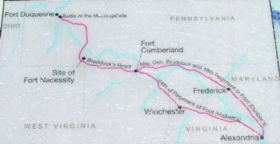
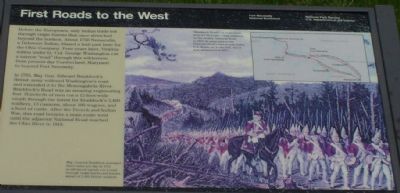
Before the Europeans, only Indian trails led through virgin forests that once stretched beyond the horizon. About 1750 Nemacolin, a Delaware Indian, blazed a trail past here for the Ohio Company. Four years later, Virginia militia under Lt. Col. George Washington cut a narrow "road" through this wilderness from present-day Cumberland, Maryland to beyond Fort Necessity.
In 1755, Maj. Gen. Edward Braddock's British army widened Washington's road and extended it to the Monongahela River. Braddock's Road was an amazing engineering feat. Hundreds of men cut a 12-foot-wide swath through the forest for Braddock's 2,400 soldiers, 13 cannons, about 100 wagons, and a herd of cattle. After the French and Indian War, this road became the main route west until the adjacent National Road reached the Ohio River in 1818.
Erected by National Park Service, U.S. Department of the Interior.
Topics and series. This historical marker is listed in these topic lists: Roads & Vehicles • Settlements & Settlers • War of 1812. In addition, it is included in the Braddock’s Road and Maj. Gen. Edward Braddock series list. A significant historical year for this entry is 1750.
Location. 39° 49.921′ N, 79° 36.041′ W. Marker is near Farmington, Pennsylvania , in Fayette County. It is in Wharton Township. Marker can be reached from National Pike (U.S. 40) 1.2 miles east of Fayette Springs Road. Touch for map. Marker is in this post office area: Farmington PA 15437, United States of America. Touch for directions.
Other nearby markers. At least 5 other markers are within walking distance of this marker. The Old Braddock Road (a few steps from this marker); Braddock Park (a few steps from this marker); A Secret Grave (within shouting distance of this marker); Road to Disaster (within shouting distance of this marker); Braddock’s Grave (within shouting distance of this marker). Touch for a list and map of all markers in Farmington.
Also see . . . John Kennedy Lacock's Braddock Road. 1914 article about the original road lavishly illustrated with maps and vintage postcards. (Submitted on May 3, 2006.)

Photographed By J. J. Prats, April 11, 2006
2. Route of Braddock's March
Caption for the map on the marker: "Braddock Road"—a main route west for 60 years—was replaced by the nearby National Road in 1818. In many places the National Road's bed is now under U.S. Route 40 to the left, which was designated in 1925.
Credits. This page was last revised on February 7, 2023. It was originally submitted on May 3, 2006, by J. J. Prats of Powell, Ohio. This page has been viewed 2,461 times since then and 18 times this year. Photos: 1, 2, 3. submitted on May 3, 2006, by J. J. Prats of Powell, Ohio.

