Natural Bridge in Rockbridge County, Virginia — The American South (Mid-Atlantic)
Natural Bridge
Time Out for Touring
| — | Hunter's Raid | — |
July 19, 2010
1. Natural Bridge Marker
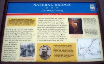
On June 14, 1864, Union Gen. David Hunter’s army marched near here en route from Lexington to Lynchburg. Union Col. David Hunter Strother wrote, “We passed within three miles of the Natural Bridge. Officers were much disappointed by not being able to see it. Lieutenant Meigs and some others did go by that road.”
After Hunter’s attack on Lynchburg was repulsed June 17-18, Confederate troops passing through this area wanted to view Natural Bridge. Assistant Surgeon Thomas Fanning Wood of the
this page online
(Sidebar): David Hunter Strother, artist and illustrator, was born in Martinsburg, Va. (now W.Va.) on Sept. 16, 1816. He studied art in Philadelphia and New York then toured the American West and Europe. Under the pen name Porte Crayon, he gained fame in the 1850s for his illustrations for Harper’s Magazine and his books, including Virginia Illustrated. He served in the U.S. Army as an officer during the Civil War and as consul-general to Mexico (1779-1885). He died in Charleston, W.Va., on Mar. 8, 1888.
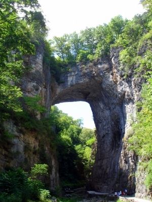
Natural Bridge, once owned by Thomas Jefferson, was one of the nation’s first tourist destinations, heavily visited during the 18th and 19th centuries by travelers from all over the world. Many explored the countryside around the bridge on horseback or in horse-drawn carriages. The braver guests were lowered over the edge from the top of the bridge in a hexagonal steel cage while a violinist played. During the Civil War, Union and Confederate officers and soldiers visited Virginia’s Natural Bridge and recorded their impressions in letters, diaries, and memoirs.
Erected by Virginia
July 19, 2010
2. Natural Bridge Marker
Topics and series. This historical marker is listed in these topic lists: Natural Features • War, US Civil. In addition, it is included in the Virginia Civil War Trails series list. A significant historical month for this entry is May 1901.
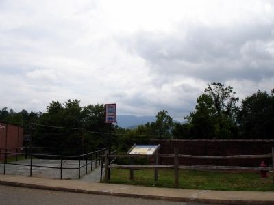
Location. Marker has been reported permanently removed. It was located near 37° 37.722′ N, 79° 32.598′ W. Marker was in Natural Bridge, Virginia, in Rockbridge County. It could be reached from Wert Faulkner Highway / Rockbridge Road (Virginia Route 130). Marker is in the front of the parking lot at the Natural Bridge visitor center. Touch for map. Marker was in this post office area: Natural Bridge VA 24578, United States of America.
We have been informed that this marker is no longer there and will not be replaced. This page is an archival view of what was.
Regionally, this marker was in the Mountain Region. It was also in the American South, specifically in the Upper South, in Appalachia, and specifically in Southern Appalachia. Globally, it was in North America, the Western Hemisphere, the Western World, and the Anglosphere. Historically, it found itself in what was

July 19, 2010
3. Natural Bridge
Other nearby markers. At least 8 other markers are within walking distance of this location: A different marker also named Natural Bridge (a few steps from this marker); a different marker also named Natural Bridge (within shouting distance of this marker); Natural Bridge Patent (about 300 feet away, measured in a direct line); “Vires-Acquirit-Eundo” Ancient Arbor Vitae (about 300 feet away); The Time-Traveling Tree of Life (about 400 feet away); A Miracle in Stone ... Old as the Dawn (about 400 feet away); How Did It Happen? (about 500 feet away); “The Most Sublime of Nature’s Works” (about 500 feet away). Touch for a list and map of all markers in Natural Bridge.
More about this marker. On the lower left of the marker is a sketch captioned “View from the Cliff,” by Strother, showing top of the Natural Bridge arch. The sidebar displays a portrait of David Hunter Strother. On the upper right of the marker is a painting captioned “Natural Bridge, Virginia,” 1852, by Frederick Edwin Church University of Virginia Art Museum. The lower right of the marker features a map of the Civil War Trails Hunter's Raid driving tour.
Also see . . .
1. Hunter's Raid (or the Lynchburg Campaign). John's Military history website entry (Submitted on March 25, 2022, by Larry Gertner of New York, New York.)
2. Natural Bridge Virginia. Natural Bridge Conference Center website entry (Submitted on July 21, 2010.)
Additional commentary.
1. Lieutenant Meigs
The Lieutenant Meigs mentioned on this marker is the same Lt. Meigs whose death is the subject of markers 15121, 15123 and 15140. In the book "A Civil War Soldier of Christ and Country," editor Mary A. Giunta summarizes the visit to Natural Bridge with the statement "John Rodgers Meigs and others were able to see the rock formation and climbed South Peak." Note To Editor only visible by Contributor and editor
— Submitted August 14, 2011, by Linda Walcroft of Woodstock, Virginia.
2. 1879, not 1779
"1779-1885" is shown in the marker text. The Wikipedia entry for David Hunter Strother has him "serving as U.S. consul in Mexico (1879–1885)".
Editor's note: Yes, the marker includes an incorrect date. Marker text is transcribed as shown on the marker. Thanks!
— Submitted September 13, 2024, by Carl Gordon Moore Jr. of North East, Maryland.
Credits. This page was last revised on September 19, 2024. It was originally submitted on July 21, 2010. This page has been viewed 3,753 times since then and 96 times this year. Photos: 1, 2, 3. submitted on July 21, 2010. • Craig Swain was the editor who published this page.
