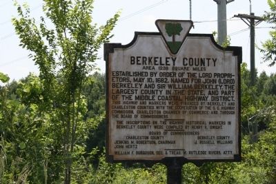
Near St. Stephen in Berkeley County, South Carolina — The American South (South Atlantic)
Berkeley County
This highway and markers were financed by Berkeley and Charleston Counties with the cooperation of the S.C. Highway Commission, Charleston Chamber of Commerce and through the Board of Commissioners. The inscriptions on the highway historical markers in Berkeley County were compiled by Henry R. Dwight. Board of Commissioners Charleston County Jenkins M. Robertson, Chairman John Hertz Berkeley County J. Russell Williams William F. Burguson, Sec. & Treas. M. Rutledge Rivers, Atty.
Erected 1940. (Marker Number 8-22A.)
Topics. This historical marker is listed in this topic list: Colonial Era. A significant historical date for this entry is May 10, 1926.
Location. 33° 29.545′ N, 79° 57.719′ W. Marker is near St. Stephen, South Carolina, in Berkeley County. Marker is on U.S. 52, on the right when traveling south. Marker is on the south side of the Santee River Bridge. Touch for map. Marker is in this post office area: Saint Stephen SC 29479, United States of America. Touch for directions.
Other nearby markers. At least 8 other markers are within 7 miles of this marker, measured as the crow flies. Thomas Walter (approx. 3.9 miles away); Maham Plantation (approx. 5.2 miles away); DeWitt Williams Bridge (approx. 5.6 miles away); Village of Pineville (approx. 6 miles away); St. Stephens Veterans Monument (approx. 6.1 miles away); McCollum-Murray House (approx. 6.4 miles away); St. Stephen's Episcopal Church (approx. 6˝ miles away); L. Mendel Rivers House (approx. 6.6 miles away). Touch for a list and map of all markers in St. Stephen.
More about this marker. This is one of ten markers once located on the major entrances of Berkeley County. Five others are in this data base and four appear to have fallen victim to bridge and road improvements. The original text was drafted in 1940 and revised in 1976. This marker is possibly the only existing marker with the original 1940 text.
Credits. This page was last revised on June 16, 2016. It was originally submitted on July 22, 2010, by David Bullard of Seneca, South Carolina. This page has been viewed 1,263 times since then and 145 times this year. Photo 1. submitted on July 22, 2010, by David Bullard of Seneca, South Carolina. • Bill Pfingsten was the editor who published this page.
