Near Tyler in Smith County, Texas — The American South (West South Central)
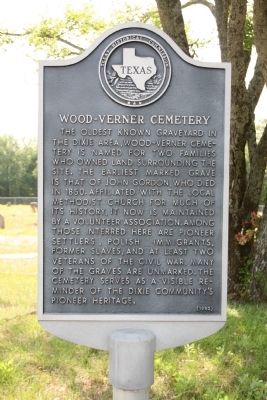
Wood-Verner Cemetery
Erected 1992 by Texas Historical Commission. (Marker Number 7769.)
Topics. This historical marker is listed in this topic list: Cemeteries & Burial Sites. A significant historical year for this entry is 1850.
Location. 32° 22.617′ N, 95° 25.733′ W. Marker is near Tyler, Texas, in Smith County. Marker is on County Road 1148, on the left when traveling north. Touch for map. Marker is in this post office area: Tyler TX 75704, United States of America. Touch for directions.
Other nearby markers. At least 8 other markers are within 6 miles of this marker, measured as the crow flies. Smith County (approx. 2.4 miles away); Pleasant Retreat United Methodist Church (approx. 2.6 miles away); New Harmony Baptist Church (approx. 3.4 miles away); County Line Missionary Baptist Church (approx. 3.8 miles away); The Major John Dean House (approx. 4.8 miles away); Cherokee Exodus from Texas (approx. 5.2 miles away); Cherokee Chief Bowles (approx. 5.2 miles away); Yarborough House (approx. 5˝ miles away). Touch for a list and map of all markers in Tyler.
More about this marker. When traveling west on CR 1148, the end loops around Wood-Verner cemetery. As you travel north on the tail end of the loop around the cemetery, marker is on your left.
Credits. This page was last revised on June 16, 2016. It was originally submitted on July 25, 2010, by Amanda Hartley of Tyler, Texas. This page has been viewed 933 times since then and 23 times this year. Photo 1. submitted on July 25, 2010, by Amanda Hartley of Tyler, Texas. • Kevin W. was the editor who published this page.
Editor’s want-list for this marker. A photo of the marker and the surrounding area in context. • Can you help?
