Near Trading Post in Linn County, Kansas — The American Midwest (Upper Plains)
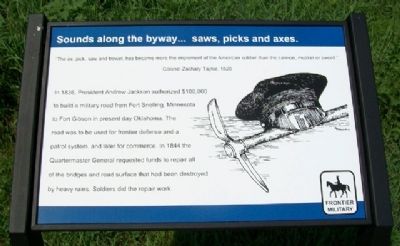
Sounds along the byway...saws, picks and axes.
Frontier Military Historic Byway
Inscription.
"The ax, pick, saw and trowel, has become more the implement of the American soldier than the cannon, musket or sword."
Colonel Zachary Taylor, 1820
In 1836, President Andrew Jackson authorized $100,000 to build a military road from Fort Snelling, Minnesota to Fort Gibson in present day Oklahoma. The road was to be used for frontier defense and a patrol system, and later for commerce. In 1844 the Quartermaster General requested funds to repair all of the bridges and road surfaces that had been destroyed by heavy rains. Soldiers did the repair work.
Erected 2010 by Frontier Military Historic Byway.
Topics and series. This historical marker is listed in these topic lists: Forts and Castles • Roads & Vehicles • Settlements & Settlers. In addition, it is included in the Former U.S. Presidents: #07 Andrew Jackson, and the Former U.S. Presidents: #12 Zachary Taylor series lists. A significant historical year for this entry is 1820.
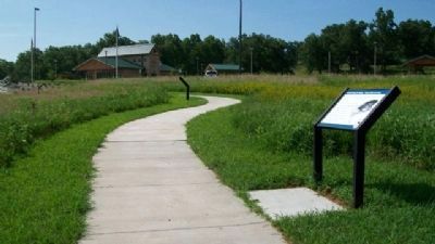
Location. 38° 15.541′ N, 94° 40.316′ W. Marker is near Trading Post, Kansas, in Linn County. Marker is at the Kansas DOT rest area, located about 1500 feet SSE of the intersection of US Highway 69 and Kansas Highway 52. Touch for map. Marker is in this post office area: Pleasanton KS 66075, United States of America. Touch for directions.
Other nearby markers. At least 8 other markers are within walking distance of this marker. Sounds along the roadway...soldiers on the move. (a few steps from this marker); Sounds along the byway...fur traders bringing their goods. (a few steps from this marker); Sounds along the byway...auto, trucks and buses. (within shouting distance of this marker); Sounds along the byway...anxiety and anticipation in the creak of wagon wheels. (within shouting distance of this marker); Sounds from the past...hoof beats and heartbeats. (within shouting distance of this marker); Sounds of the byway...moccasins and tears. (within shouting distance of this marker); Marais Du Cygne Martyrs Memorial (approx. 0.7 miles away); Marais des Cygnes Massacre (approx. 0.7 miles away). Touch for a list and map of all markers in Trading Post.
Also see . . .
1. Frontier Military Historic Byway. (Submitted on August 2, 2010, by William Fischer, Jr. of Scranton, Pennsylvania.)
2. The Frontier Military Road and the Founding of Fort Scott. (Submitted on August 2, 2010, by William Fischer, Jr. of Scranton, Pennsylvania.)
Credits. This page was last revised on September 9, 2020. It was originally submitted on August 2, 2010, by William Fischer, Jr. of Scranton, Pennsylvania. This page has been viewed 687 times since then and 8 times this year. Photos: 1, 2. submitted on August 2, 2010, by William Fischer, Jr. of Scranton, Pennsylvania.

