Near Fredericksburg in Spotsylvania County, Virginia — The American South (Mid-Atlantic)
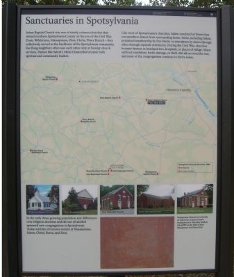
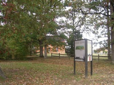
Sanctuaries in Spotsylvania
Fredericksburg and Spotsylvania National Military Park
— National Park Service, U.S. Department of the Interior —
Salem Baptist Church was one of nearly a dozen churches that dotted northern Spotsylvania County on the eve of the Civil War. Zoan, Wilderness, Massaponax, Zion, Christ, Piney Branch – They collectively served as the backbone of the Spotsylvania community. Far-flung neighbors often saw each other only at Sunday church services. Pastors like Salem’s Melzi Chancellor became both spiritual and community leaders.
Like most of Spotsylvania’s churches, Salem consisted of fewer than 100 members drawn from surrounding farms. Some, including Salem, permitted membership by free blacks or attendance by slaves (thought often through separate entrances). During the Civil War, churches became famous as headquarters, hospitals, or places of refuge. Many suffered vandalism, battle damage, or theft. But all survived the war, and most of the congregations continue to thrive today.
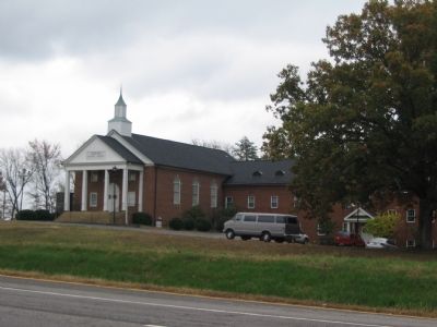
(Modern day pictures of Civil War era churches include): Wilderness Baptist Church, Berea Christian Church, Zion Methodist Church, Christ Episcopal Church, and Massaponax Baptist Church.
(Picture caption, lower left): In the early 1800s growing population and differences over religious doctrine and the use of alcohol spawned new congregations in Spotsylvania. Today wartime structures remain at Massaponax, Salem, Christ, Berea, and Zion.
(Picture caption, lower right): Massaponax Church served briefly as Union Gen. Ulysses Grant’s headquarters in May 1864. Soldiers left graffiti on the walls at both Massaponax and Salem (left).
Erected by National Park Service, U.S. Department of the Interior.
Topics and series. This historical marker is listed in these topic lists: Churches & Religion • Military • War, US Civil. In addition, it is included in the Former U.S. Presidents: #18 Ulysses S. Grant series list. A significant historical month for this entry is May 1864.
Location. 38° 17.298′ N, 77° 31.853′ W. Marker is near Fredericksburg, Virginia, in Spotsylvania County. Marker can be reached from Old Salem Church Road near Plank Road (Virginia Route 3). This marker is colocated with two other markers near the parking lot for the Old Salem Church (Civil War Battlefield) Site. Touch for map. Marker is at or near this postal address: 4044 Plank Road, Fredericksburg VA 22407, United States of America. Touch for directions.
Other nearby markers. At least 8 other markers are within walking distance of this marker. Churchyard to Battleground (here, next to this marker); For All Anguish – For Some Freedom (here, next to this marker); Salem Church (within shouting distance of this marker); Old Salem Church (within shouting distance of this marker); Refuge from Horror (within shouting distance of this marker); The Battle of Salem Church (about 300 feet away, measured in a direct line); From Church to Hospital (about 300 feet away); a different marker also named Battle of Salem Church (about 300 feet away). Touch for a list and map of all markers in Fredericksburg.
Regarding Sanctuaries in Spotsylvania. This is one of five stops at Salem Church related to the Battle of Chancellorsville. See the Salem Church Virtual Tour by Markers in the links section for a listing of related markers on the tour.
Related markers. Click here for a list of markers that are related to this marker. To better understand the relationship, study each marker in the order shown.
Also see . . .
1. Salem Church Virtual Tour by Markers. The Salem Church site, surrounded by modern development, was an important site in the later stages of the Battle and Campaign of Chancellorsville. (Submitted on November 12, 2007, by Craig Swain of Leesburg, Virginia.)
2. Salem Church Walking Trail. National Park Service Trail guide. (Submitted on November 12, 2007, by Craig Swain of Leesburg, Virginia.)

Photographed By Craig Swain, November 10, 2007
3. Zoan Church
At the time of the Civil War a wood church, built in 1844, occupied this site just over two miles west of Salem Church. During the early phases of the Chancellorsville Campaign, Confederate General Richard Anderson's Division entrenched on the ridge here. The position covered both the Orange Turnpike, Orange Plank Road, and Mine Road. The later led to United States Ford and was a crossing point for the Federal army.
Credits. This page was last revised on February 2, 2023. It was originally submitted on November 12, 2007, by Kevin W. of Stafford, Virginia. This page has been viewed 1,301 times since then and 51 times this year. Photos: 1, 2. submitted on November 12, 2007, by Kevin W. of Stafford, Virginia. 3. submitted on November 12, 2007, by Craig Swain of Leesburg, Virginia. 4. submitted on July 25, 2015, by Brandon Fletcher of Chattanooga, Tennessee.


