Florence in Lauderdale County, Alabama — The American South (East South Central)
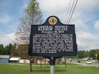
General Hood's Narrow Escape
December 26, 1864
Erected by Florence Historical Board, Florence, Alabama.
Topics. This historical marker is listed in this topic list: War, US Civil. A significant historical month for this entry is December 1965.
Location. 34° 47.972′ N, 87° 39.829′ W. Marker is in Florence, Alabama, in Lauderdale County. Marker is on Veterans Drive. Marker is located beside Florence Coliseum on Veterans Drive. Touch for map. Marker is in this post office area: Florence AL 35630, United States of America. Touch for directions.
Other nearby markers. At least 8 other markers are within walking distance of this marker. Old Confederate Fort (a few steps from this marker); Soldier's Rest (approx. 0.2 miles away); Patton Elementary School (approx. 0.3 miles away); Florence Cemetery (approx. 0.3 miles away); St. Joseph Catholic Church (approx. 0.4 miles away); "Mountain" Tom Clark (approx. 0.4 miles away); Florence Bethel Cumberland Presbyterian Church in America (approx. 0.4 miles away); East Florence Historic District (approx. 0.4 miles away). Touch for a list and map of all markers in Florence.
Credits. This page was last revised on June 16, 2016. It was originally submitted on September 3, 2010, by Sandra Hughes Tidwell of Killen, Alabama, USA. This page has been viewed 1,913 times since then and 30 times this year. Photo 1. submitted on September 3, 2010, by Sandra Hughes Tidwell of Killen, Alabama, USA. • Craig Swain was the editor who published this page.
