Near Falmouth in Stafford County, Virginia — The American South (Mid-Atlantic)
Sow…Tend…Harvest
Fredericksburg and Spotsylvania National Military Park
— National Park Service, U.S. Department of the Interior —
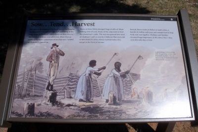
For most of its existence, Chatham had an unchanging rhythm: sow, tend, and harvest, each according to the crop. Most of Chatham’s slaves lived out their lives to this seasonal cadence, year after year. More than 50 enslaved workers—sometimes more than 100 tended to Chatham’s 1,300 acres.
Slaves in these fields managed huge swaths of wheat or long rows of corn. Some of the crop went to feed the plantation’s cattle. The rest was ground into meal at Chatham’s mill on nearby Claiborne Run and sold to merchants in town. Slaves received none of it, except in the form of rations.
Instead, slaves received shelter in small cabins, a bundle of clothes each year, and enough food to keep body and soul together. Holidays and Sundays assumed huge importance in the slaves’ lives—they were the only days of rest.
Erected 2010 by National Park Service, U.S. Department of the Interior.
Topics. This historical marker is listed in these topic lists: African Americans • Agriculture.
Location. This marker has been replaced by another marker nearby. It was located near 38° 18.548′ N, 77° 27.298′ W. Marker was near Falmouth, Virginia, in Stafford County. Marker could be reached from Chatham Drive near Chatham Heights Road. Touch for map. Marker was at or near this postal address: 120 Chatham Lane, Fredericksburg VA 22405, United States of America. Touch for directions.
Other nearby markers. At least 8 other markers are within walking distance of this location. A Changed Landscape (here, next to this marker); a different marker also named Sow…Tend…Harvest (a few steps from this marker); Beyond the Big House (within shouting distance of this marker); Chatham and the Civil War (within shouting distance of this marker); Chatham (within shouting distance of this marker); a different marker also named Chatham (within shouting distance of this marker); Fredericksburg and Spotsylvania National Military Park (within shouting distance of this marker); A “Picture of Desolation” (about 400 feet away, measured in a direct line). Touch for a list and map of all markers in Falmouth.
More about this marker. On the bottom is a painting with the caption, “A 1798 painting of slaves working under the gaze of an overseer near Fredericksburg. This is the only known image of Fredericksburg-area slaves at work.” Courtesy Maryland Historical Society
Related marker. Click here for another marker that is related to this marker. New Marker At This Location also titled "Sow…Tend…Harvest".
Credits. This page was last revised on November 14, 2021. It was originally submitted on September 7, 2010, by Bernard Fisher of Richmond, Virginia. This page has been viewed 753 times since then and 10 times this year. Photos: 1, 2, 3. submitted on September 7, 2010, by Bernard Fisher of Richmond, Virginia.


