
Spring Creek in Madison County, Tennessee — The American South (East South Central)
Forrest's Raid
Dec. 19, 1862
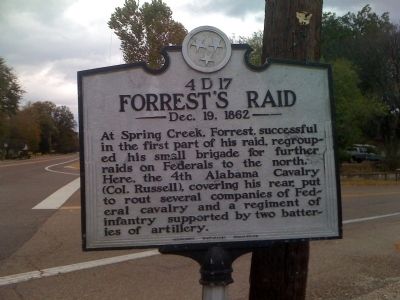
Photographed by L. David Barnette, October 24, 2010
1. Forrest's Raid Marker
Courtesy of Bell's Partisans Camp #1821 - Sons of Confederate Veterans
Erected by Tennessee Historical Commission. (Marker Number 4 D 17.)
Topics and series. This historical marker is listed in this topic list: War, US Civil. In addition, it is included in the Tennessee Historical Commission series list.
Location. 35° 45.872′ N, 88° 40.681′ W. Marker is in Spring Creek, Tennessee, in Madison County. It is at the intersection of U.S. 70 and Spring Creek Law Road (State Highway 152), on the right on U.S. 70. Touch for map. Marker is in this post office area: Spring Creek TN 38378, United States of America. Touch for directions.

Regionally, this marker is in West Tennessee. It is also in the American South, specifically in the Deep South, and specifically in the Upper South. Globally, it is in North America, the Western
this page online
Other nearby markers. At least 8 other markers are within 11 miles of this marker, measured as the crow flies: Cotton Grove (approx. 4.7 miles away); Medina Veterans Memorial (approx. 6.1 miles away); Mount Zion (approx. 8.3 miles away); Skirmish At Carroll Station (approx. 8.4 miles away); Former Site of Milan Army Ammunition Plant Housing Area (approx. 10.2 miles away); Large Oak Tree (approx. 10½ miles away); Unknown Sentry Stands Guard (approx. 10½ miles away); The Battle of Salem Cemetery (approx. 10.6 miles away).
Another marker is no longer nearby. Adam Huntsman (was approx. 8.4 miles away but has been confirmed missing).
Credits. This page was last revised on June 16, 2016. It was originally submitted on October 24, 2010, by L. David Barnette of Trenton, Tennessee. This page has been viewed 1,544 times since then and 32 times this year. Photo 1. submitted on October 24, 2010, by L. David Barnette of Trenton, Tennessee. • Craig Swain was the editor who published this page.
