Trenton in Gibson County, Tennessee — The American South (East South Central)
Forrest at Trenton
Inscription.
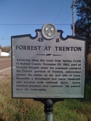
Advancing along this route from Spring Creek in Madison County, December 20, 1862, part of Forrest's Brigade under his command captured the Federal garrison at Trenton, entrenched around the station on the west side of town. Meanwhile a detachment had taken Humboldt and wrecked both railroads there. Seven hundred prisoners were captured. He paused here for regrouping.
Erected by Tennessee Historical Commission. (Marker Number 4B 8.)
Topics and series. This historical marker is listed in this topic list: War, US Civil. In addition, it is included in the Tennessee Historical Commission series list. A significant historical date for this entry is December 20, 1862.
Location. 35° 58.849′ N, 88° 56.853′ W. Marker is in Trenton, Tennessee, in Gibson County. Marker is on West Eaton Street (Tennessee Route 104). Touch for map. Marker is in this post office area: Trenton TN 38382, United States of America. Touch for directions.
Other nearby markers. At least 8 other markers are within 4 miles of this marker, measured as the crow flies. Fighting for Trenton (about 500 feet away, measured in a direct line); David Crockett (approx. 0.3 miles away); Gibson County Courthouse (approx. 0.3 miles away); Gibson County Confederate Memorial (approx. 0.3 miles away); a different marker also named Fighting for Trenton (approx. 0.3 miles away); Female Collegiate Institute (approx. half a mile away); a different marker also named Fighting for Trenton (approx. 0.7 miles away); C.S.A. Camp Trenton (approx. 3.4 miles away). Touch for a list and map of all markers in Trenton.
Additional commentary.
1.
Note To Editor only visible by Contributor and editor
— Submitted October 24, 2010, by L. David Barnette of Trenton, Tennessee.
Additional keywords. Forrest's Raid
Credits. This page was last revised on June 16, 2016. It was originally submitted on October 24, 2010, by L. David Barnette of Trenton, Tennessee. This page has been viewed 1,060 times since then and 21 times this year. Photo 1. submitted on October 24, 2010, by L. David Barnette of Trenton, Tennessee. • Craig Swain was the editor who published this page.
