Near David City in Butler County, Nebraska — The American Midwest (Upper Plains)
Shinn's Ferry
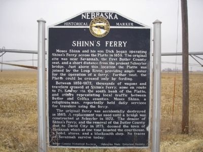
Photographed by Bob Pasonault, December 19, 2010
1. Shinn's Ferry Marker
Between 1859-1872, thousands of wagons and travelers crossed at Shinn's Ferry, some en route to Ft. Kearny via the south bank of the Platte, and others representing local traffic between Butler and Colfax counties: Moses Shinn, a religious man, reportedly held daily services for travelers using the ferry.
The original ferry was accidentally destroyed in 1865. A replacement was used until a bridge was constructed at Schuyler in 1872. The demise of Shinn's Ferry, and the removal of the Butler county seat to David City in 1873, doomed the town of Savannah which at one time boated the courthouse, a hotel, stores and a blacksmith shop. No traces of Savannah survive today.
Erected by Butler County Historical Society & Nebraska Historical Society.
this page online
Topics and series. This historical marker is listed in these topic lists: Settlements & Settlers • Waterways & Vessels. In addition, it is included in the Nebraska State Historical Society series list. A significant historical year for this entry is 1859.
Location. 41° 20.22′ N, 97° 8.351′ W. Marker is near David City, Nebraska, in Butler County. It is on Road 41 close to Road M, on the right. Touch for map. Marker is in this post office area: Bellwood NE 68624, United States of America. Touch for directions.

Regionally, this marker is in the American Midwest, in the Corn Belt, and on the prairies. Globally, it is in North America, the Western Hemisphere, the Western World, and the Anglosphere. Historically, it finds itself in what was once the Louisiana Purchase.
Other nearby markers. At least 8 other markers are within 6 miles of this marker, measured as the crow flies: The Site of Savannah (here, next to this marker); Built in 1900 as The Boston Studio (approx. 5.7 miles away); T. B. Myers Building (approx. 5.7 miles away); Wolfe Building (approx. 5.7 miles away); North Side of the Square (approx. 5.8 miles away); Schweser's (approx. 5.8 miles away); To the Pioneers of Butler County (approx. 5.8 miles away); Thorpe Opera House (approx. 5.9 miles away). Touch for a list and map of all markers in David City.
Credits. This page was last revised on December 20, 2024. It was originally submitted on December 19, 2010, by Bob Pasonault of Columbus, Nebraska. This page has been viewed 1,664 times since then and 47 times this year. Photo 1. submitted on December 19, 2010, by Bob Pasonault of Columbus, Nebraska. • Bill Pfingsten was the editor who published this page.
Editor’s want-list for this marker. A wide shot of the marker showing it in its surroundings • Can you help?
