John Dickinson Plantation near Dover in Kent County, Delaware — The American Northeast (Mid-Atlantic)
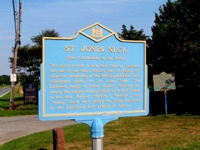
St. Jones Neck
Site of Settlement in the 1660's
Erected by Delaware Public Archives. (Marker Number K-44.)
Topics and series. This historical marker is listed in these topic lists: Colonial Era • Environment • Settlements & Settlers. In addition, it is included in the Delaware Public Archives series list.
Location. 39° 6.134′ N, 75° 26.483′ W. Marker is near Dover, Delaware, in Kent County. It is in John Dickinson Plantation. Marker is on Kitts Hummock Road close to Bergold Lane. Marker used to be located at the entrance of the John Dickinson Plantation historic site. It was moved to the entrance of the St. Jones Reserve a bit further down the road. The coordinates given are for the current location, but the picture of the marker is from its old location. Touch for map. Marker is in this post office area: Dover DE 19901, United States of America. Touch for directions.
Other nearby markers. At least 8 other markers are within 2 miles of this marker, measured as the crow flies. The St. Jones River: Why the Mansion Faces South (approx. 0.4 miles away); Home of John Dickinson (approx. half a mile away); Byfield (approx. 1.1 miles away); C-45G (approx. 1.3 miles away); C-60 (approx. 1.3 miles away); U-3A (approx. 1.3 miles away); LGM-30 (approx. 1.3 miles away); C-5 (approx. 1.3 miles away). Touch for a list and map of all markers in Dover.
Credits. This page was last revised on September 17, 2023. It was originally submitted on January 9, 2011, by Nathan Davidson of Salisbury, Maryland. This page has been viewed 852 times since then and 45 times this year. Photo 1. submitted on January 9, 2011, by Nathan Davidson of Salisbury, Maryland. • Bill Pfingsten was the editor who published this page.
