Marble Canyon in Coconino County, Arizona — The American Mountains (Southwest)
Lees Ferry
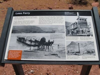
In 1873, Mormon Church members opened a wagon road from Kanab, Utah, and built a ferryboat here. John D. Lee was the first ferryman and namesake of the site.
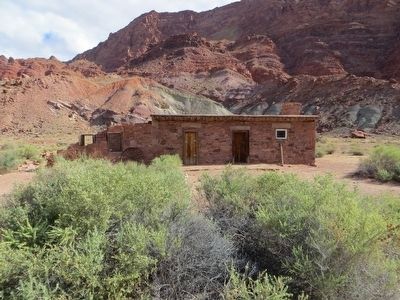
Pioneers, sent to settle the Little Colorado River in northern Arizona, used the ferry service. Lees Ferry grew to include a post office and a trading post. Because of the conflict between the settlers and the Navajo Indians, a fort was built but never attacked. In 1911, Charles H. Spencer unsuccessfully attempted to mine gold from the clay hills behind the Lees Ferry Fort.
On large photo at the left bottom of marker:
1) For 55 years, a veriety of boats transported settlers, missionaries, miners, traders, Indians, and tourists across the river at Lees Ferry. Boats capsized and people drowned, but the service continued until 1928.
2) Walk the short trail to Lees Ferry Fort, past Spencer's mining machinery and buildings. Look down on the sunken steamboat and try to imagine crossing this river on a ferry.
On top right photo:
Built in 1912, this paddlewheel steamboat, the Charles H. Spencer, hauled coal to Lees Ferry from Warm Creek, 28 miles (45 km) upstream. The coal fueled Spencer's gold mining machinery. Abandoned in 1914, it sank in the shallow water nearby.
On bottom right photo:
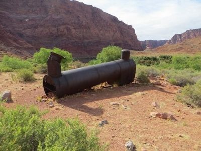
This boiler powered the steam engines for gold mining at Lees Ferry. Charles H. Spencer's machinery could not extract the fine, powdery gold dust from the Chinle clay.
Erected by National Park Service.
Topics. This historical marker is listed in these topic lists: Industry & Commerce • Settlements & Settlers • Waterways & Vessels. A significant historical year for this entry is 1873.
Location. 36° 51.996′ N, 111° 34.993′ W. Marker is in Marble Canyon, Arizona, in Coconino County. Turn near Marble Canyon Lodge on US Highway 89A. There's a sign directing one toward "Lee's Ferry." Go to the end of Lee's Ferry Road and park in the parking lot. Touch for map. Marker is in this post office area: Marble Canyon AZ 86036, United States of America. Touch for directions.
Other nearby markers. At least 8 other markers are within 5 miles of this marker, measured as the crow flies. A different marker also named Lee's Ferry (about 600 feet away, measured in a direct line); Charles H. Spencer “Paddlewheel” Steamboat (approx. 0.2 miles away); Navajo Bridge (approx. 4.3 miles away); Navajo Bridge Erection Toggle Screw / Navajo Bridge (approx. 4.3 miles away); Lewis Nez (approx. 4.3 miles away); John Deering
(approx. 4.3 miles away); a different marker also named Navajo Bridge (approx. 4.3 miles away); Lafe McDaniel (approx. 4.3 miles away). Touch for a list and map of all markers in Marble Canyon.
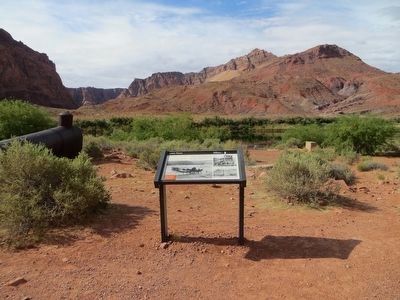
More about this marker. One must walk, about 900 feet, to the marker from the parking lot at the end of Lee's Ferry Road.
Credits. This page was last revised on June 16, 2016. It was originally submitted on April 26, 2011, by Jack Duffy of West Jordan, Utah. This page has been viewed 1,201 times since then and 30 times this year. Photos: 1. submitted on April 26, 2011, by Jack Duffy of West Jordan, Utah. 2. submitted on May 26, 2016, by Bill Kirchner of Tucson, Arizona. 3. submitted on April 30, 2011, by Mike Stroud of Bluffton, South Carolina. 4, 5. submitted on May 26, 2016, by Bill Kirchner of Tucson, Arizona. 6. submitted on May 27, 2016, by Bill Kirchner of Tucson, Arizona. • Syd Whittle was the editor who published this page.
