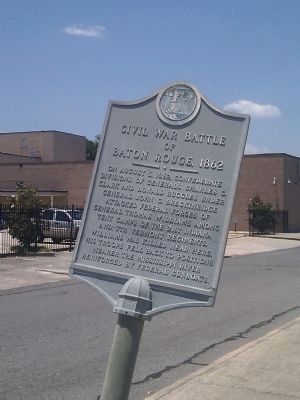
Mid City North in Baton Rouge in East Baton Rouge Parish, Louisiana — The American South (West South Central)
Civil War Battle of Baton Rouge
1862
Topics. This historical marker is listed in this topic list: War, US Civil. A significant historical year for this entry is 1862.
Location. 30° 27.058′ N, 91° 10.266′ W. Marker is in Baton Rouge, Louisiana, in East Baton Rouge Parish. It is in Mid City North. Marker is at the intersection of Laurel Street and North 17th Street, on the right when traveling west on Laurel Street. Located two blocks west of the entrance to Magnolia Cemetery. Touch for map. Marker is in this post office area: Baton Rouge LA 70802, United States of America. Touch for directions.
Other nearby markers. At least 8 other markers are within walking distance of this marker. Magnolia Cemetery (about 600 feet away, measured in a direct line); St. Joseph Catholic Cemetery (about 800 feet away); The First Cemetery In Baton Rouge (approx. 0.2 miles away); National Cemetery (approx. 0.2 miles away); A National Cemetery System (approx. 0.2 miles away); Genl. Philemon Thomas (approx. 0.2 miles away); Massachusetts Memorial (approx. 0.2 miles away); Yellow Fever Memorial (approx. 0.2 miles away). Touch for a list and map of all markers in Baton Rouge.
Credits. This page was last revised on February 12, 2023. It was originally submitted on June 3, 2011, by Cliff Lemoine of Bryant, Arkansas. This page has been viewed 1,962 times since then and 16 times this year. Photo 1. submitted on June 3, 2011, by Cliff Lemoine of Bryant, Arkansas. • Craig Swain was the editor who published this page.
Editor’s want-list for this marker. Wide area shot of marker area. • Can you help?
