Knoxville in Knox County, Tennessee — The American South (East South Central)
Fort Dickerson
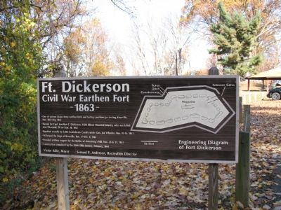
Civil War Earthen Fort
• One of sixteen Union Army earthen forts and battery positions protecting Knoxville, Nov. 1863–May 1865.
• Named for Capt. Jonathan C. Dickerson, 112th Illinois Mounted Infantry who was killed near Cleveland, TN on Sept. 18, 1863.
• Repulsed assaults by 5,000 Confederate Cavalry under Gen. Joe Wheeler, Nov 15-16, 1863
• Withstood the Siege of Knoxville, Nov 17–Dec 4, 1863.
• Provided artillery support for the Battles of Armstrong’s Hill, Nov 25 & 29, 1863.
• Construction completed by the 104th Ohio Battery, February, 1864.
Erected by Victor Ashe, Mayor • Samuel P. Anderson, Recreation Director.
Topics and series. This historical marker is listed in this topic list: War, US Civil. In addition, it is included in the Battlefield Trails - Civil War series list. A significant historical year for this entry is 1865.
Location. 35° 56.919′ N, 83° 54.977′ W. Marker is in Knoxville, Tennessee, in Knox County. Marker can be reached from Fort Dickerson Road west of Chapman Highway, on the left when traveling north. Touch for map. Marker is in this post office area: Knoxville TN 37920, United States of America. Touch for directions.
Other nearby markers. At least 8 other markers are within walking distance of this marker. Fort Dickerson 1863–64 (here, next to this marker); Civil War Knoxville (here, next to this marker); The 1863 Siege of Knoxville (here, next to this marker); a different marker also named Fort Dickerson (within shouting distance of this marker); a different marker also named Fort Dickerson (within shouting distance of this marker); Forts Dickerson and Stanley (approx. 0.2 miles away); a different marker also named Fort Dickerson (approx. 0.3 miles away); Back Door to Knoxville (approx. 0.3 miles away). Touch for a list and map of all markers in Knoxville.
More about this marker. Marker has a large Engineering Diagram of Fort Dickerson.
Regarding Fort Dickerson. This is one of several markers interpreting Fort Dickerson and Civil War activity around Knoxville. See the Fort Dickerson Virtual Tour by Markers linked below.
Related markers. Click here for a list of markers that are related to this marker. Fort Dickerson Virtual Tour by Markers
Credits. This page was last revised on September 22, 2020. It was originally submitted on November 30, 2007, by Laura Troy of Burke, Virginia. This page has been viewed 2,332 times since then and 34 times this year. Photos: 1, 2. submitted on November 30, 2007, by Laura Troy of Burke, Virginia. • Craig Swain was the editor who published this page.

