Akron in Summit County, Ohio — The American Midwest (Great Lakes)
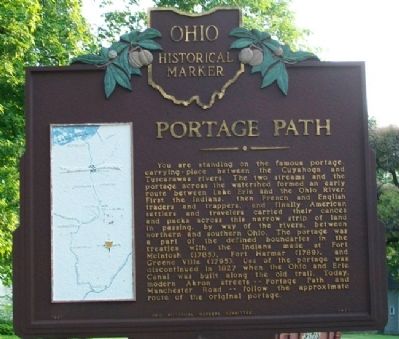
Portage Path
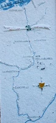
You are standing on the famous portage, carrying-place between the Cuyahoga and Tuscarawas rivers. The two streams and the portage across the watershed formed an early route between Lake Erie and the Ohio River. First the Indians, then French and English traders and trappers, and finally American settlers and travelers carried their canoes and packs across this narrow strip of land in passing, by way of the rivers, between northern and southern Ohio. The portage was a part of the defined boundaries in the treaties with the Indians made at Fort McIntosh (1785), Fort Harmar (1789), and Green Ville (1795). Use of the portage was discontinued in 1827 when the Ohio and Erie Canal was built along the old trail. Today, modern Akron streets--Portage Path and Manchester Road--follow the approximate route of the original portage.
Erected 1957 by Ohio Historical Markers Committee. (Marker Number 1-77.)
Topics and series. This historical marker is listed in these topic lists: Exploration • Native Americans • Settlements & Settlers • Waterways & Vessels. In addition, it is included in the Ohio Historical Society / The Ohio History Connection series list. A significant historical year for this entry is 1827.
Location. 41° 5.065′ N, 81° 32.538′ W. Marker is in Akron, Ohio, in Summit County. Marker is at the intersection of Portage Path / Diagonal Road and Copley Road, on the right when traveling south on Portage Path / Diagonal Road. Touch for map. Marker is at or near this postal address: 550 Copley Road, Akron OH 44333, United States of America. Touch for directions.
Other nearby markers. At least 8 other markers are within 2 miles of this marker, measured as the crow flies. Abolitionist John Brown (a few steps from this marker); Hall Park Allotment Historic District (approx. half a mile away); Dr. Bob's Home (approx. 0.9 miles away); Glendale Steps (approx. one mile away); 09.11.2001 (approx. one mile away); Fueling Growth in a New Century (approx. 1.2 miles away); Heating a City (approx. 1.3 miles away); Contributions Of African Americans To Akron's Rubber Industry (approx. 1.3 miles away). Touch for a list and map of all markers in Akron.
Also see . . . The Portage Path. (Submitted on June 19, 2011, by William Fischer, Jr. of Scranton, Pennsylvania.)
Credits. This page was last revised on June 16, 2016. It was originally submitted on June 19, 2011, by William Fischer, Jr. of Scranton, Pennsylvania. This page has been viewed 1,188 times since then and 71 times this year. Photos: 1, 2, 3. submitted on June 19, 2011, by William Fischer, Jr. of Scranton, Pennsylvania.


