
Near Brandy Station in Culpeper County, Virginia — The American South (Mid-Atlantic)
The Battle of Brandy Station
The Struggle for Fleetwood Hill
Photographed by Craig Swain, December 22, 2007
1. The Battle of Brandy Station Marker
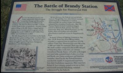
The hill changed hands several times as the battle devolved into a giant swirling melee: men from New York, New Jersey, Pennsylvania, Maryland, and Maine struggled against Virginians, Georgians, Carolinians, and Mississippians.
By late afternoon, the Federals had used all their reserves. Though Brig. Gen. John Buford continued to press back the Confederates on northern Fleetwood Hill, the southern slopes were held by exhausted but triumphant Southerners. After Col. Thomas Munford's fresh Confederate brigade arrived on Buford's flank and rear, the Union commander, Brig Gen. Alfred Pleasonton, saw that further effort was fruitless and ordered his subordinates to pull back across the Rappahannock
this page online
In nearly 14 hours of fighting, Confederate Maj. Gen. J.E.B. Stuart lost about 500 men killed, wounded, or captured from his total force of 9,700 soldiers; Union Gen. Pleasonton lost some 900 of the 11,000 men under his command. These may seem like small numbers compared to the terrible toll paid at Gettysburg three weeks later, yet veterans remembered Brandy Station with pride as the largest and most hotly contested clash of sabers in a long and bloody war. Union cavalrymen and historians remember June 9 as the day Federal horsemen snatched the mantle of unquestioned superiority from their Confederate opponents. Most important, Robert E. Lee's infantry, poised to set out on their march north toward Gettysburg, remained undiscovered by the Federals.
Help Preserve Battlefields • call CWPT at 1-888-606-1400 • www.civilwar.org • The Hallowell Foundation generously contributed toward the interpretation of this site in memory of Carrington Williams.
This material is based upon work assisted by a grant from the Department of the Interior, National Park Service. Any opinion, findings and conclusions or recommendations expressed in this material are those of the author(s) and do not necessarily reflect the views of the Department of the Interior.
Erected by Civil
Photographed by Craig Swain, December 22, 2007
2. The Fleetwood Hill Overlook Stop
Topics. This historical marker is listed in this topic list: War, US Civil. A significant historical date for this entry is June 9, 1848.
Location. This marker has been replaced by another marker nearby. It was located near 38° 30.449′ N, 77° 52.997′ W. Marker was near Brandy Station, Virginia, in Culpeper County. It was on Fleetwood Heights Road (County Route 685), on the right when traveling east. Located on the Civil War Preservation Trust's Fleetwood Hill exhibition area for the Battle of Brandy Station. Touch for map. Marker was in this post office area: Brandy Station VA 22714, United States of America. Touch for directions.

Regionally, this marker was in the Washington Metropolitan Area and in Northern Virginia. It was also in the American South, specifically in the Upper South, and in the Mid-Atlantic. Globally, it was in North America, the Western Hemisphere, the Western World, and the Anglosphere. Historically, it found itself in what was once the territory of the Mississippian Culture, one of the original Thirteen Colonies, one of the Confederate States of America, and the Antebellum South.
Photographed by Craig Swain, December 22, 2007
3. Fleetwood Hill Battle Map
Other nearby markers. At least 8 other markers are within walking distance of this location: A different marker also named Battle of Brandy Station (a few steps from this marker); a different marker also named Battle of Brandy Station (a few steps from this marker); a different marker also named Battle of Brandy Station (approx. ¼ mile away); a different marker also named Battle of Brandy Station (approx. ¼ mile away); a different marker also named Battle of Brandy Station (approx. ¼ mile away); a different marker also named Battle of Brandy Station (approx. ¼ mile away); a different marker also named Battle of Brandy Station (approx. ¼ mile away); a different marker also named Battle of Brandy Station (approx. ¼ mile away). Touch for a list and map of all markers in Brandy Station.
Another marker is no longer nearby. The Battle of Brandy Station (has been replaced with this marker).
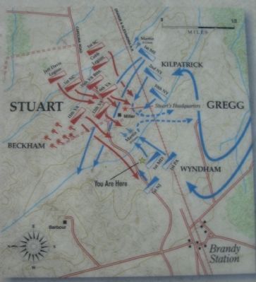
More about this marker. On the lower left is "Edwin Forbes' period sketch of a cavalry charge." On the right is a map illustrating the cavalry action described in the text.
Regarding The Battle of Brandy Station. This is one of several
Photographed by Craig Swain, December 22, 2007
4. Fleetwood Hill
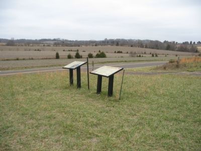
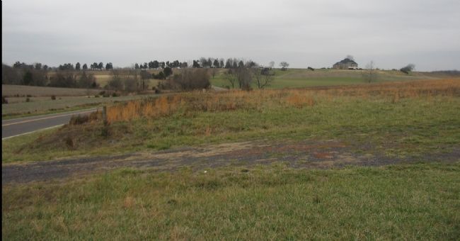
Some modern buildings have changed the profile of Fleetwood Hill, but it is still possible to follow the action here. Col. Wyndham's command approached across the location of the markers, almost directly into the foreground from this view. Col. Kilpatrick followed Wyndham with an attack from the southeast of Fleetwood Hill (from the right of the photo) with an axis of advance aimed at the large modern house on the hill.
Related marker. Click here for another marker that is related to this marker. New Marker at this Location titled "Battle of Brandy Station - A Show of force on Fleetwood Hill"
Also see . . .
1. Battle of Brandy Station. National Park Service website entry (Submitted on December 30, 2007, by Craig Swain of Leesburg, Virginia.)
2. Brandy Station Foundation. Through the efforts of the Brandy Station Foundation, Civil War Preservation Trust, and other organizations, over 960 acres of this battlefield have been preserved. (Submitted on December 30, 2007, by Craig Swain of Leesburg, Virginia.)
3. Battle of Brandy Station Virtual Tour by Markers. A set markers that document the Battle of Brandy Station, June 9, 1863, and the Winter Encampment of 1863-64. Note the order of appearance is geographic and not chronologically aligned to the battle. (Submitted on January 1, 2008, by Craig Swain of Leesburg, Virginia.)
Credits. This page was last revised on May 16, 2025. It was originally submitted on December 30, 2007, by Craig Swain of Leesburg, Virginia. This page has been viewed 2,145 times since then and 20 times this year. Photos: 1, 2, 3, 4. submitted on December 30, 2007, by Craig Swain of Leesburg, Virginia.
