Brevard in Transylvania County, North Carolina — The American South (South Atlantic)
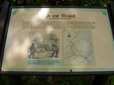
Draw Road
A link with the outside world
(sidebar)
Good wagon roads were key to Dr. Schenck's plan for managing Vanderbilt's forest. By 1905 he reported having built 80 miles of road worth $40,350.
Topics. This historical marker is listed in these topic lists: Horticulture & Forestry • Roads & Vehicles. A significant historical year for this entry is 1905.
Location. 35° 21.07′ N, 82° 46.844′ W. Marker is in Brevard, North Carolina, in Transylvania County. Marker can be reached from U.S. 276, half a mile south of Yellow Gap Road, on the right when traveling south. Touch for map. Marker is in this post office area: Pisgah Forest NC 28768, United States of America. Touch for directions.
Other nearby markers. At least 8 other markers are within walking distance of this marker. Wash Place (within shouting distance of this marker); Hell Hole (within shouting distance of this marker); Commissary (about 300 feet away, measured in a direct line); Ranger's Dwelling (about 300 feet away); Schenck's Office (about 400 feet away); Blacksmith (about 500 feet away); Rock House Creek Lodge (about 500 feet away); Forestry School (about 500 feet away). Touch for a list and map of all markers in Brevard.
Credits. This page was last revised on June 16, 2016. It was originally submitted on July 5, 2011, by Stanley and Terrie Howard of Greer, South Carolina. This page has been viewed 449 times since then and 9 times this year. Photos: 1, 2. submitted on July 5, 2011, by Stanley and Terrie Howard of Greer, South Carolina. • Bernard Fisher was the editor who published this page.

