Near Lewis and Clark Village in Buchanan County, Missouri — The American Midwest (Upper Plains)
The Lewis and Clark Expedition Across Missouri
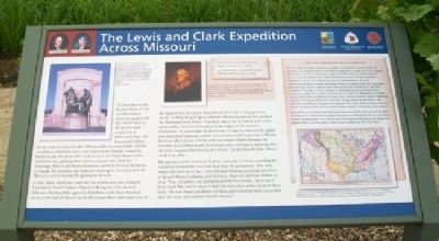
Inscription.
The land that would become Missouri and 14 other western states was acquired by the United States in the greatest land acquisition in American history: the Louisiana Purchase. By the stroke of a pen, President Thomas Jefferson ensured the country would be a continental power, reaching from the Atlantic toward the Pacific Ocean. For about three cents an acre, the United States nearly doubled its size, gaining almost 830,000 square miles from the Mississippi River to the Rocky Mountains, and from the Gulf of Mexico to Canada. The purchase also had great meaning for the future state of Missouri, soon to become the gateway to the west.
In 1800, Spain, which had controlled the region since 1762, returned Louisiana to French Emperor Napoleon Bonaparte. This alarmed Jefferson, who feared the aggressive Napoleon could block American access to the Gulf of Mexico via the Mississippi River. Americans west of the Appalachian Mountains depended on this route to ship goods to market. To keep the gulf open, Jefferson offered to purchase the mouth of the Mississippi from France. Napoleon was at war in Europe and a slave revolt in Haiti had ended his plans for an empire in the western hemisphere. He desperately needed money to wage his wars and he rightly concluded that American control of Louisiana would keep it out of British hands as effectively as a French army stationed in North America. He therefore made Jefferson and his representatives in France a stunning offer: all of the Louisiana Territory for $15 million. The purchase became official on April 30, 1803.
The purchase of the Louisiana Territory took place without consulting the numerous Indian tribes who had lived there for generations. They were simply informed of the fact. Carlos Dehault Delassus, lieutenant governor of Spanish Upper Louisiana, told Delaware, Shawnee and Sauk Indians in 1804: "Your old fathers, the Spaniards and the Frenchmen...by an act of their Good Will, and in virtue of their last treaty, have delivered up all these lands. The new [American] father will keep and defend the land and protect all of the white and redskins who live thereon."
Lewis and Clark Explore the New Territory
President Thomas Jefferson planned an expedition to the Pacific Ocean well before the purchase of Louisiana. On Jan. 18, 1803, Jefferson proposed to Congress that "An intelligent officer with ten or twelve chosen men...might explore the whole line [of the Missouri River], even to the Western ocean." But in summer 1803, news of the land acquisition changed the mission of the impending Lewis and Clark Expedition. No longer a semi-secret intelligence mission into foreign territory, the captains could now concentrate on preparing the way for
commerce with Indian nations and establishing the uncertain boundaries of the huge territory by means of careful observations and measurements. Ceremonies with Indians would now mention the new "father" in Washington. At the first council, with the Otoe and Missouri in August 1804, Clark described the captains "Delivering a Speech informing thos Children of ours of the Change which had taken place." The expedition also had greater urgency as an inspection tour of new American lands to find and describe the Indian nations, as well as plants, animals and the "soil and face of the country."
In March 1804, two months before departure, Lewis and possibly Clark attended the official ceremony in St. Louis transferring Upper Louisiana to the United States. No one quite knew, however, the boundaries of this new territory. The western border was in such dispute that Spanish soldiers tried, but failed, to intercept the expedition on the Great Plains.
Let the Land rejoice, for you have bought Louisiana for a Song."
General Horatio Gates to President Thomas Jefferson, July 18, 1803
Erected by Missouri Department of Natural Resources, National Park Service, and Missouri Lewis and Clark Bicentennial Commission.
Topics and series. This historical marker is listed in these topic lists: Exploration

Photographed By Missouri Department of Natural Resources, undated
3. The Lewis and Clark Expedition Across Missouri Marker
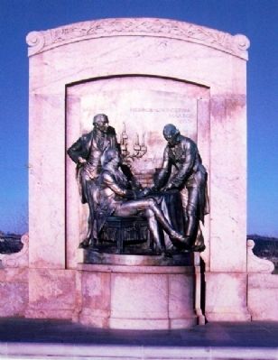
[Caption reads] A bronze relief by Karl Bitter at the Missouri State Capitol portrays United States envoy Robert R. Livingston (seated) and James Monroe witnessing the French minister of finance, Marquis François de Barbe-Marbois, signing the purchase agreement for the Louisiana Territory. This was one of the greatest diplomatic events in young America's history.
Location. 39° 32.11′ N, 95° 3.727′ W. Marker is near Lewis and Clark Village, Missouri, in Buchanan County. Marker can be reached from Lakeshore Drive. Marker is along the trail in the Lewis and Clark Expedition Interpretive Area of Lewis and Clark State Park, 801 Lakecrest Boulevard (Missouri Route 138), about 1.5 miles west of Missouri Routes 45/273. Touch for map. Marker is at or near this postal address: 1199 Lakeshore Dr, Rushville MO 64484, United States of America. Touch for directions.
Other nearby markers. At least 8 other markers are within 4 miles of this marker, measured as the crow flies. A different marker also named The Lewis and Clark Expedition Across Missouri (a few steps from this marker); Lewis and Clark in Missouri (within shouting distance of this marker); Atchison Veterans Memorial (approx. 3.3 miles away in Kansas); The Lewis and Clark Expedition (approx. 3.3 miles away in Kansas); Homeland of the Kanza Indians (approx. 3.3 miles away in Kansas); "walked on Shore above this Creek"

Photographed By Williams Engraving Company, NY, 1805
4. Map on The Lewis and Clark Expedition Across Missouri Marker
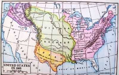
[Caption reads] The vast Louisiana Territory, 830,000 square miles bought for about three cents an acre, eventually became all or part of 15 states: Louisiana, Arkansas, Missouri, Iowa, North Dakota, Texas, South Dakota, New Mexico, Nebraska, Kansas, Wyoming, Minnesota, Oklahoma, Colorado and Montana.
Also see . . .
1. Lewis and Clark Across Missouri. Website homepage (Submitted on July 14, 2011, by William Fischer, Jr. of Scranton, Pennsylvania.)
2. Lewis and Clark National Historic Trail. National Park Service website homepage (Submitted on July 14, 2011, by William Fischer, Jr. of Scranton, Pennsylvania.)
3. Lewis and Clark in Missouri. Missouri Department of Conservation website entry (Submitted on July 14, 2011, by William Fischer, Jr. of Scranton, Pennsylvania.)
4. The Journals of the Lewis and Clark Expedition. Website homepage (Submitted on July 14, 2011, by William Fischer, Jr. of Scranton, Pennsylvania.)
Credits. This page was last revised on April 24, 2022. It was originally submitted on July 14, 2011, by William Fischer, Jr. of Scranton, Pennsylvania. This page has been viewed 1,352 times since then and 45 times this year. It was the Marker of the Week May 11, 2014. Photos: 1, 2, 3, 4. submitted on July 14, 2011, by William Fischer, Jr. of Scranton, Pennsylvania.

