Council Grove in Morris County, Kansas — The American Midwest (Upper Plains)
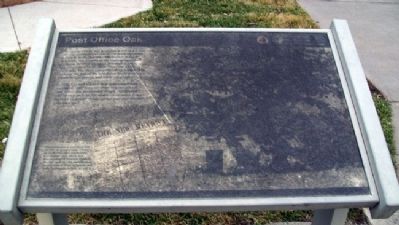
Post Office Oak
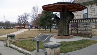
The stump before you is all that is left of a grand old oak tree that was about 270 years old when it died in 1990. The tree, which once stood 80 feet high, was located in the campground used by Santa Fe Trail travelers. It is said to have been used as a "post office" from the 1820s to the 1840s. Travelers reputedly left messages in [the] cavity at the foot of the tree about water sources, Plains Indian unrest, and other information.
In 1855, Council Grove's first postmaster was appointed. But, because there was no official post office, the postmaster simply distributed mail from a sack on the street, or emptied it onto the floor of a store where postal patrons claimed their own mail.
Communication is something that we take for granted today. During Santa Fe Trail days, information moved much more slowly. For instance, news of President Abraham Lincoln's April 14, 1865, assassination reached Council Grove on April 20, and Santa Fe fifteen days later, on May 5.
Erected by National Park Service, City of Council Grove, and Morris County Historical Society.
Topics and series. This historical marker is listed in these topic lists: Communications • Roads & Vehicles • Settlements & Settlers. In addition, it is included in the Historic Trees, the Postal Mail and Philately, and the Santa Fe Trail series lists. A significant historical date for this entry is April 14, 1748.
Location. 38° 39.708′ N, 96° 29.179′ W. Marker is in Council Grove, Kansas, in Morris County. Marker is on Main Street (U.S. 56) near Union Street, on the left when traveling east. Touch for map. Marker is in this post office area: Council Grove KS 66846, United States of America. Touch for directions.
Other nearby markers. At least 8 other markers are within walking distance of this marker. A different marker also named Post Office Oak (a few steps from this marker); Brewery (a few steps from this marker); Madonna of the Trail (within shouting distance of this marker); Bur Oak (within shouting distance of this marker); Rendezvous on the Trail (about 300 feet away, measured in a direct line); a different marker also named Bur Oak (about 400 feet away); Guardian of the Grove (about 500 feet away); Council Oak (about 600 feet away). Touch for a list and map of all markers in Council Grove.
More about this marker. The fiberglass marker is heavily mildewed and barely legible.
Also see . . .
1. Our Rich History. Council Grove Area Trade & Tourism Association website entry (Submitted on July 24, 2011, by William Fischer, Jr. of Scranton, Pennsylvania.)
2. 8 Wonders of Kansas History: Council Grove, Santa Fe Trail National Historic Landmark. Kansas Sampler Foundation website entry (Submitted on July 24, 2011, by William Fischer, Jr. of Scranton, Pennsylvania.)
3. Santa Fe National Historic Trail. National Park Service website entry (Submitted on July 24, 2011, by William Fischer, Jr. of Scranton, Pennsylvania.)
4. Santa Fe Trail Association. Association website entry (Submitted on July 24, 2011, by William Fischer, Jr. of Scranton, Pennsylvania.)
Credits. This page was last revised on August 23, 2023. It was originally submitted on July 24, 2011, by William Fischer, Jr. of Scranton, Pennsylvania. This page has been viewed 590 times since then and 9 times this year. Photos: 1, 2. submitted on July 24, 2011, by William Fischer, Jr. of Scranton, Pennsylvania.

