Council Grove in Morris County, Kansas — The American Midwest (Upper Plains)
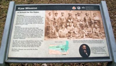
Kaw Mission
A School for the Kaws
"Great father, you white people treat us like a flock of turkeys. You chase us from one steam and then chase us to another stream and then to another stream. Soon you will chase us over the mountains and into the ocean
- Al-le-ga-wa-ho, Chief of the Kaws, 1872
"[The Kaw Mission School] averaged about thirty pupils, all boys. The branches taught were spelling, reading, writing, and arithmetic. None of them received instruction in the trades. The boys worked well on the farm."
- Teacher Thomas Huffaker, 1905
The Mission
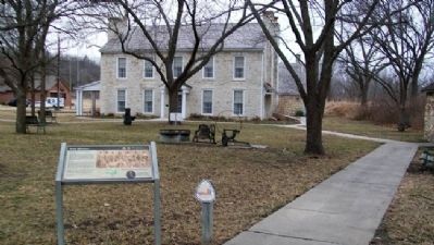
In 1850, workers from the Shawnee Methodist Mission near Kansas City traveled 110 miles on the Santa Fe Trail to build this mission and boarding school for Kaw (Kansa) Indian boys. The mission opened in 1851, with funding from the U.S. government. However, the government reported that the operational costs were too high, and the school and mission closed in 1854.
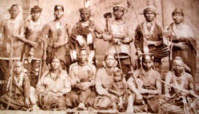
The Kaws
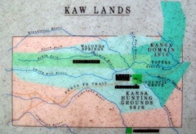
This land was once part of Kaw and Osage homelands. In the early 1800s, the Kaws' domain extended well beyond today's state borders. By 1848, the federal government forced the Kaw people onto a twenty-mile-square reservation surrounding Council Grove. About 1,000 people, struggling with disease and starvation, lived in three nearby villages. In 1873, the remaining 600 Kaws were relocated to Indian Territory (Oklahoma).
By 1997, only one pure-blooded Kaw was alive. That year, the Kaw Nation, headquartered in Kaw City, Oklahoma, had 2,300 members. It is now stronger economically, politically, and socially than at any other time since the days of the Santa Fe Trail.
The State of Kansas was named for the Kaw (Kansa) tribe.
Erected by National Park Service, City of Council Grove, and Kansas State Historical Society.
Topics and series. This historical marker is listed in these topic lists: Churches & Religion • Education • Native Americans • Settlements & Settlers. In addition, it is included in the Santa Fe Trail series list. A significant historical year for this entry is 1872.
Location. 38° 39.941′ N, 96° 29.612′ W. Marker is in Council Grove, Kansas, in Morris County. Marker is on Mission Street near Huffaker Street, on the right when traveling north. Touch for map. Marker is at or near this postal address: 500 North Mission Street, Council Grove KS 66846, United States of America. Touch for directions.
Other nearby markers. At least 8 other markers are within walking distance of this marker. The Mormon Battalion at Council Grove, Kansas (here, next to this marker); Mill Stone (a few steps from this marker); Kaw House Reconstructed (a few steps from this marker); Hermit's Cave (approx. ¼ mile away); a different marker also named Hermit's Cave (approx. ¼ mile away); Old Bell (approx. 0.3 miles away); The Cottage House Hotel and Motel (approx. 0.3 miles away); Neosho Crossing (approx. 0.3 miles away). Touch for a list and map of all markers in Council Grove.
Also see . . .
1. Kaw Mission. An Intersection of Cultures entry (Submitted on January 20, 2021, by Larry Gertner of New York, New York.)
2. The Kaw Nation. People of the Southwind website (Submitted on July 26, 2011, by William Fischer, Jr. of Scranton, Pennsylvania.)
3. Santa Fe National Historic Trail: The Great Prairie Highway. National Park Service entry (Submitted on July 26, 2011, by William Fischer, Jr. of Scranton, Pennsylvania.)
4. Indian Missions in Kansas. Kansas History listing (Submitted on July 26, 2011, by William Fischer, Jr. of Scranton, Pennsylvania.)
Credits. This page was last revised on November 2, 2023. It was originally submitted on July 25, 2011, by William Fischer, Jr. of Scranton, Pennsylvania. This page has been viewed 625 times since then and 15 times this year. Photos: 1, 2, 3, 4. submitted on July 26, 2011, by William Fischer, Jr. of Scranton, Pennsylvania.


