The Pawnee: Prairie Town Builders, Pawnee History
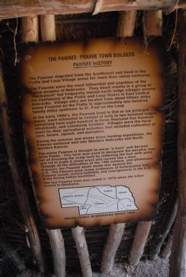
The Pawnee were the most influential and populous of the native peoples of Nebraska. They dwelt mainly in a group of “Permanent” but frequently moved earth-lodge villages around the confluence of the Platte and Loup Rivers in East Central Nebraska. Village sites are located from about fifteen miles below Fremont on the Platte to approximately one hundred twenty miles upstream to St. Paul on the Loup. In the early 1800’s, the Pawnee lived in five or six principal towns, each estimated to consist of forty to two hundred lodges containing from eight hundred to three thousand five-hundred inhabitants, and commonly fortified. Villages were the local point for their agricultural activities that included cultivation of corn, beans, squash, and pumpkins.
During the summer and winter bison hunting expeditions, the Pawnee ventured well into Western Nebraska and Northwestern Kansas.
The name Pawnee is thought to mean “a horn” and derived from Pakiki. This term was used to designate the peculiar manner of dressing the scalp-lock by stiffening the hair with paint and fat to make it stand erect and curved like a horn. Through all the difficulties of the 19th century, and white mans diseases, the Pawnee never made war against the U.S. The Pawnee gave many evidences of forbearance and Pawnee scouts served faithfully and courageously in the U.S. Army during Indian hostilities. The Last Pawnee tract was ceded in 1876 when tribes moved to Oklahoma.
Topics. This historical marker is listed in this topic list: Indigenous Peoples and Communities. A significant historical year for this entry is 1876.
Location. 40° 52.876′ N, 98° 22.509′ W.
this page online

Regionally, this marker is in Central Nebraska and in the Platte River Valley. It is also in the American Midwest, in the Corn Belt, and on the prairies. Globally, it is in North America, the Western Hemisphere, the Western World, and the Anglosphere. Historically, it finds itself in what was once the Louisiana Purchase.
Other nearby markers. At least 8 other markers are within 4 miles of this marker, measured as the crow flies: Earth Lodge Design and Construction (here, next to this marker); Old California Overland Trail (about 300 feet away, measured in a direct line); Mormon Trail (about 700 feet away); Grand Island (approx. 1.6 miles away); La Grande Isle (approx. 1.6 miles away); Original Home of the Stolley Family (approx. 1.6 miles away); Oldest Remaining School House (approx. 1.6 miles
Credits. This page was last revised on June 16, 2016. It was originally submitted on July 29, 2011, by Charles T. Harrell of Woodford, Virginia. This page has been viewed 1,128 times since then and 42 times this year. Photos: 1, 2. submitted on July 29, 2011, by Charles T. Harrell of Woodford, Virginia. • Bill Pfingsten was the editor who published this page.
