Crow Agency in Big Horn County, Montana — The American West (Mountains)
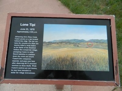
Lone Tipi
June 25, 1876
— Approximately 2:00 p.m. —
Topics. This historical marker is listed in this topic list: Wars, US Indian.
Location. 45° 31.485′ N, 107° 23.028′ W. Marker is in Crow Agency, Montana, in Big Horn County. Marker can be reached from U.S. 212, one mile east of Interstate 90. Marker is near the end of the battlefield drive. Touch for map. Marker is in this post office area: Crow Agency MT 59022, United States of America. Touch for directions.
Other nearby markers. At least 8 other markers are within walking distance of this marker. Crow's Nest (here, next to this marker); Reno's Skirmish Line - Warrior Counterattack (here, next to this marker); Retreat Crossing (here, next to this marker); Timber Fight (here, next to this marker); Reno’s Retreat (about 400 feet away, measured in a direct line); Reno’s Valley Fight (about 400 feet away); Custer’s Advance (about 400 feet away); The Reno-Benteen Defense (approx. 0.3 miles away). Touch for a list and map of all markers in Crow Agency.
Credits. This page was last revised on June 16, 2016. It was originally submitted on August 4, 2011, by Bill Pfingsten of Bel Air, Maryland. This page has been viewed 4,817 times since then and 193 times this year. Photos: 1, 2. submitted on August 4, 2011, by Bill Pfingsten of Bel Air, Maryland.

