Our Changing Landscape-From Sea Floor to Mountain Top
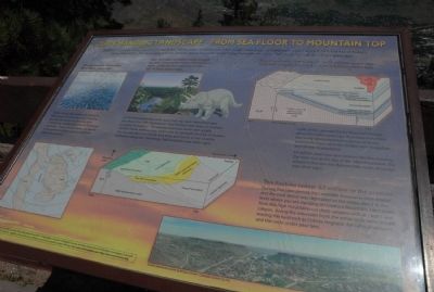
•The sea covers Colorado: 80 million years ago. Today’s Rocky Mountains did not exist. Where you are standing and all before you was beneath a shallow sea that covered the middle of the North American continent. Today, marine fossils are found in the sediments deposited at that time (Pierre Formation). •Sea retreats as mountains begin to rise dinosaurs leave footprints near subtropical coal swamps: 68 million years ago. As the seas withdrew, sand, mud, and clay were deposited near the shore (Fox Hills Formation). Coal formed near rivers in swamps (Laramie Formation). The environment was warm with ample rainfall. These sedimentary rocks now lie beneath the City of Golden. You can see dinosaur tracks and large leaf fossils in the Laramie Formation along the Triceratops Trail in Golden (see other sign).
•The mountains form highest 60-68 million
this page online
•The Rockies today: 63 million to the present. During that time period, the Laramide mountains were eroded and the rock debris was deposited on the plains about to the level where you are standing on Lookout Mountain. Later, rivers from the high mountains cut deep canyons such as Clear Creek canyon. Along the mountain front, the softer rocks were eroded leaving the hard rock as Dakota Hogback, the Table Mountains, and the rocks under your feet.
Topics. This historical marker is listed in this topic list: Natural Features.
Location. 39° 44.025′ N, 105° 14.335′ W. Marker is near Golden, Colorado, in Jefferson County. It is in Lakota Hills. It can be reached


Regionally, this marker is in the Front Range. It is also in the American Mountain West. Globally, it is in North America, the Rocky Mountains, the Western Hemisphere, the Western World, and the Anglosphere. Historically, it finds itself in what was once the Louisiana Purchase.
Other nearby markers. At least 8 other markers are within walking distance of this marker: What You Can See From Here Today (here, next to this marker); Who Was Buffalo Bill? (within shouting distance of this marker); Lariat Loop Byway: Buffalo Bill Museum (within shouting distance of this marker); Lariat Loop Byway: Denver Mountain Parks (within shouting distance of this marker); Buffalo Bill's Grave — Frequently Asked Questions (about 400 feet away); Buffalo Bill's Grave — Why is Buffalo Bill Buried Here? (about 500 feet away); Buffalo Bill (about 500 feet away); Windy Saddle Park / Connecting to the Past (approx. 0.4 miles away). Touch for a list and map of all markers in Golden.
Another marker is no longer nearby. In Memory of Charles E. Kirk (was about 300 feet away, measured in a direct line but has been confirmed missing).
Credits. This page was last revised on November 18, 2025. It was originally submitted on August 24, 2011, by Charles T. Harrell of Woodford, Virginia. This page has been viewed 1,020 times since then and 35 times this year. Photos: 1. submitted on August 24, 2011, by Charles T. Harrell of Woodford, Virginia. 2. submitted on November 2, 2025, by Leslie Eudy of Golden, Colorado. • Bill Pfingsten was the editor who published this page.
