Tennessee ~Tombigbee Waterway
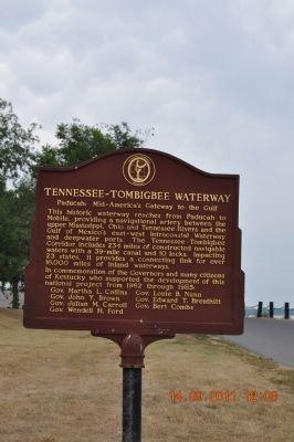
In commemoration of the Governors and many citizens of Kentucky who supported the development of this national project from 1962 through 1985:
Gov. Martha L. Collins •
Gov. John Y. Brown •
Gov. Julian M. Carroll •
Gov. Wendell H. Ford •
Gov. Louie B. Nunn •
Gov. Edward T. Breathitt •
Gov. Bert Combs
Topics. This historical marker is listed in this topic list: Waterways & Vessels. A significant historical year for this entry is 1962.
Location. 37° 5.425′ N, 88° 35.766′ W. Marker is in Paducah, Kentucky, in McCracken County. It is on N. 2nd Street close to Monroe Street. Along the Ohio River just a few feet away from Raymond C. Schultz Park Marker. Touch for map. Marker is in this post office area: Paducah KY 42001, United States of America. Touch for directions.
Regionally, this marker is in the Jackson Purchase. It is also in the American Midwest, in the South, in the Upper South, and in the Ohio River Valley. Globally, it is in North America, the Western Hemisphere, the Western World, and the Anglosphere. Historically, it finds itself in what was once the territory of the Mississippian Culture and also the Antebellum South.
Other nearby markers. At least 8 other markers are within walking distance of this marker: Raymond C. Schultz Park (here, next to this marker); Lewis and Clark in Kentucky McCracken County / McCracken County
this page online
Credits. This page was last revised on June 16, 2016. It was originally submitted on September 16, 2011, by Sandra Hughes Tidwell of Killen, Alabama, USA. This page has been viewed 565 times since then and 16 times this year. Photos: 1, 2. submitted on September 16, 2011, by Sandra Hughes Tidwell of Killen, Alabama, USA. • Bill Pfingsten was the editor who published this page.
