Oxford in Furnas County, Nebraska — The American Midwest (Upper Plains)
The Republican River Flood of 1935
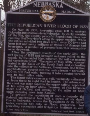
Photographed by Tim Lange, circa August 1, 1987
1. The Republican River Flood of 1935 Marker
After the prolonged drouth of the early 30's, the wet spring of 1935 had brought welcome relief to the region. By the end of May, however, the soil was nearing the saturation point. The rains of May 30th, concentrated in the basin of the South Fork and extending into the valleys of the Arikaree, Frenchman, Red Willow, and Medicine, poured into the main stream--normally 300 to 400 feet wide, turning it into a raging torrent one to four miles wide.
The flood water came as a wall, variously estimated at from three to eight feet in height. The advance of the crest was more rapid in the upper valley, reported at ten miles an hour above Trenton, at five between there and Oxford, and slowing to 2 1/2 miles an hour upon crossing over into Kansas.
To
this page online
Erected by Oxford Rotary Club - Historical Land Mark Council. (Marker Number 39.)
Topics and series. This historical marker is listed in these topic lists: Disasters • Waterways & Vessels. In addition, it is included in the Nebraska State Historical Society, and the Rotary International series lists. A significant historical month for this entry is May 1859.
Location. 40° 15.486′ N, 99° 40.302′ W. Marker is in Oxford, Nebraska, in Furnas County. It is on U.S. 136, on the right when traveling west. Marker is 2.1 miles west of Oxford. Touch for map. Marker is in this post office area: Oxford NE 68967, United States of America. Touch for directions.

Regionally, this marker is in Eastern Nebraska and in the Republican River Valley. It is also in the American Midwest, in the Corn Belt, and on the prairies. Globally, it is in North America, the Western Hemisphere, the Western World, and the Anglosphere. Historically, it finds itself in what was once the Louisiana Purchase.
Other nearby markers. At least one other marker is within 12 miles of this marker, measured as the crow flies: Nebraska's Flying Doctor (approx. 11.2 miles away).
Credits. This page was last revised on January 7, 2025. It was originally submitted on October 20, 2011, by Tim Lange of Lafayette, Indiana. This page has been viewed 1,637 times since then and 28 times this year. Photo 1. submitted on October 20, 2011, by Tim Lange of Lafayette, Indiana. • Bill Pfingsten was the editor who published this page.
Editor’s want-list for this marker. A wide view photo of the marker and the surrounding area together in context. • A clear close up photo of the marker. • Can you help?
