Champlain in Clinton County, New York — The American Northeast (Mid-Atlantic)
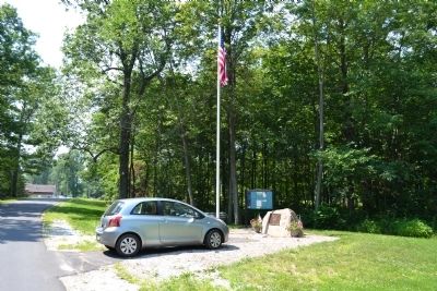
Point au Fer Historic Site
The northern half of Lake Champlain used to be controlled by the French. On June 6, 1760, during the French and Indian War (1754-1763), British Army Major Robert Rogers and his rangers engaged a French force nearby at Scales Point and pushed them into Canada. After 1763, Britain controlled all of lake Champlain, including Point au Fer.
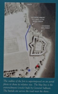
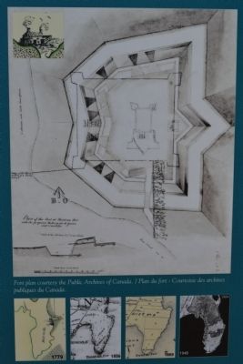
In 1774, the British built a garrison known as the "White House." In May of 1775, a small American force gained control of the fort. In June of 1776, American General John Sullivan added an entrenchment around the fort (the creek at the corner) and a 12-foot wooden stockade that was lined with cannon. Benjamin Franklin landed here on his way to Montreal at this time. Benedict Arnold, Charles Carroll and Ethan Allen stopped here.
After the Battle of Valcour in 1776, the Americans lost control of Point au Fer. Half of General John Burgoyne's British army camped here in July of 1777 on their way to Saratoga where they were defeated.
After the Revolutionary War, the British occupied the garrison for 20 more years. British Captain John Steele used his gunboat "Maria" to patrol the lake from here. He built a small garden at Stony Point that was referred to as "Steele's Garden" for decades. The Jay Treaty ended the interesting - and potentially dangerous - situation of British occupation of Point au Fer.
The fort was burned by a French refugee in 1805. During the War of 1812, American soldiers camped around the ruins while watching for British naval activities in the northern part of the lake.
The State of New York had Point au Fer surveyed into three lots and auctioned off in 1809. Thirty years later, George Rochester bought some property at the tip of the island from John Walker. Rochester descendants still live here on the Point. Around 1870, Richard Scales purchased Lot No. 2 and built his house on the ruins of the old garrison. The cellar was made of stonework of the fort. The house still stands.
The land within the White House's stockade is probably the most historic site on all of Clinton County. The fields and forests around this site have remained largely untouched. Few sites in the Champlain Valley can attest to this. Let this area remain sacred.
Erected 2009 by Lake Champlain Basin Program, Explore NY - Hudson, Fulton, Champlain.
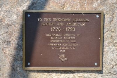
Topics and series. This historical marker is listed in these topic lists: Forts and Castles • War of 1812 • War, French and Indian • War, US Revolutionary. In addition, it is included in the Daughters of the American Revolution series list. A significant historical month for this entry is May 1775.
Location. 44° 56.649′ N, 73° 21.149′ W. Marker is in Champlain, New York, in Clinton County. Marker is on Point au Fer Road. Touch for map. Marker is in this post office area: Champlain NY 12919, United States of America. Touch for directions.
Other nearby markers. At least 8 other markers are within 3 miles of this marker, measured as the crow flies. The "White House" (about 400 feet away, measured in a direct line); Site of Joel Smith's Home (approx. 2.3 miles away); Ezra Thurber’s Home (approx. 2˝ miles away); David Mayo's Sail Ferry (approx. 2.7 miles away); Site of First School House (approx. 2.8 miles away); Samuel de Champlain Monument (approx. 3 miles away in Vermont); Site of French Fort Ste. Anne (approx. 3 miles away in Vermont); A Place Of Pilgrimage (approx. 3 miles away in Vermont).
Credits. This page was last revised on November 12, 2023. It was originally submitted on October 25, 2011, by Joe Harness of Little Egg Harbor, New Jersey. This page has been viewed 2,478 times since then and 193 times this year. Last updated on October 21, 2023, by Carl Gordon Moore Jr. of North East, Maryland. Photos: 1, 2, 3, 4, 5, 6, 7, 8, 9. submitted on October 25, 2011, by Joe Harness of Little Egg Harbor, New Jersey. • Michael Herrick was the editor who published this page.

