Fort Erie in Niagara Region, Ontario — Central Canada (North America)
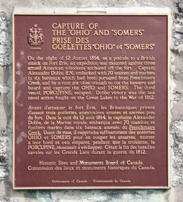
Capture of the "Ohio" and "Somers"
Prise des Goelettes "Ohio" et "Somers"
Photographed by Dale K. Benington, July 28, 2011
1. Capture of the "Ohio" and "Somers" Marker
Avant d'attaquer le fort Érié, les Britanniques prirent d'assaut trois goélettes américaines armées et ancrées près du fort. Dans la nuit du 12 août 1814, le capitaine Alexander Dobbs, de la Marine royale, embarqua avec 70 matelots et fusiliers marins dans six bateaux amenés du Frenchman's Creek. Usant de ruse, il s'approcha suffisamment des goélettes OHIO et SOMERS pour en couper les amarres, monter à leur bord et s'en emparer, pendant que la troisième, la PORCUPINE, réussissait à s'échapper. C'était la fin des batailles navales sur les Grands Lacs durant la guerre de 1812.
Erected by Historic Sites and
this page online
Topics and series. This historical marker is listed in these topic lists: Colonial Era • War of 1812. In addition, it is included in the Canada, Historic Sites and Monuments Board series list. A significant historical year for this entry is 1814.
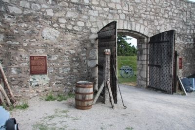
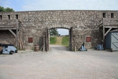
Location. 42° 53.594′ N, 78° 55.42′ W. Marker is in Fort Erie, Ontario, in Niagara Region. It is on Lakeshore Road south of Dominion Road, on the right when traveling south. This historic marker is located in Old Fort Erie. In order to see this historic marker one must park your vehicle in the Old Fort Erie Park's parking lot, pay the entrance fee in the park's Visitor Center, walk into the fort through the main gate, and then turn to the right to see where the historical marker is affixed to the inner wall of the fort, just to the right (north) of the front gate. Touch for map. Marker is at or near this postal address: 350 Lakeshore Road, Fort Erie ON L2A 1B1, Canada. Touch for directions.

Regionally, this marker is on the Golden Horseshoe and in Niagara Canada. It is also in Central Canada. Globally, it is in North America, on the Great Lakes, in
Photographed by Dale K. Benington, July 28, 2011
2. Capture of the "Ohio" and "Somers" Marker
View of the historical marker, affixed to the inner wall, to the left (north) of the fort's main gate.
Other nearby markers. At least 8 other markers are within 2 kilometers of this marker, measured as the crow flies: Fort Erie (a few steps from this marker); The First Fort Erie (about 90 meters away, measured in a direct line); Fort Erie, Pro Patria Mori Cairn (about 120 meters away); Niagara's Freedom Trail - The Crossing (approx. 1.1 kilometers away); The Royal Canadian Legion - Frontier Branch 71 - Lest We Forget (approx. 1.4 kilometers away); Fort Erie Cenotaph (approx. 1.6 kilometers away); Erie Beach Park (approx. 1.6 kilometers away); The View from the Dance Hall (approx. 1.6 kilometers away). Touch for a list and map of all markers in Fort Erie.
Also see . . . Capture of the Somers and Ohio - War of 1812. This is a link to information provided by a Military History site, sponsored by Norwich University (Submitted on November 1, 2011, by Dale K. Benington of Toledo, Ohio.)
Photographed by Dale K. Benington, July 28, 2011
3. Capture of the "Ohio" and "Somers" Marker
View of the front gate, and the historic markers that are located on either side of the gate, from the interior of Fort Erie.
Photographed by Dale K. Benington, July 28, 2011
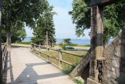
4. Capture of the "Ohio" and "Somers" Site
View looking out from the outer gate of Old Fort Erie, towards the area on Lake Erie between Buffalo, New York and Fort Erie, where the "Ohio" and "Somers" were captured.
Credits. This page was last revised on November 8, 2025. It was originally submitted on October 29, 2011, by Dale K. Benington of Toledo, Ohio. This page has been viewed 789 times since then and 17 times this year. Photos: 1, 2, 3, 4. submitted on November 1, 2011, by Dale K. Benington of Toledo, Ohio.
